Happy Valley Topo Map Arizona
To zoom in, hover over the map of Happy Valley
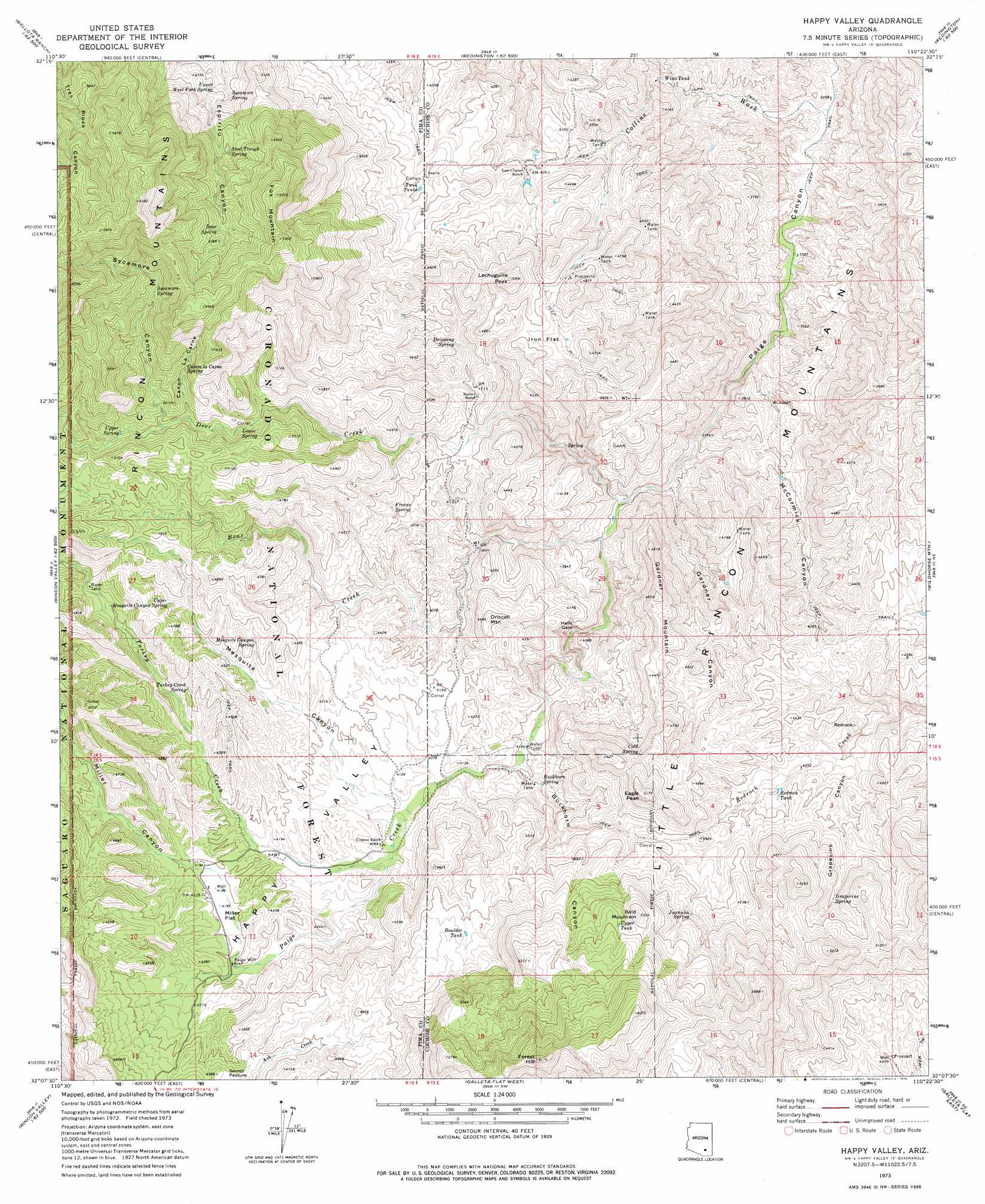
USGS Topo Quad 32110b4 - 1:24,000 scale
| Topo Map Name: | Happy Valley |
| USGS Topo Quad ID: | 32110b4 |
| Print Size: | ca. 21 1/4" wide x 27" high |
| Southeast Coordinates: | 32.125° N latitude / 110.375° W longitude |
| Map Center Coordinates: | 32.1875° N latitude / 110.4375° W longitude |
| U.S. State: | AZ |
| Filename: | o32110b4.jpg |
| Download Map JPG Image: | Happy Valley topo map 1:24,000 scale |
| Map Type: | Topographic |
| Topo Series: | 7.5´ |
| Map Scale: | 1:24,000 |
| Source of Map Images: | United States Geological Survey (USGS) |
| Alternate Map Versions: |
Happy Valley AZ 1973, updated 1976 Download PDF Buy paper map Happy Valley AZ 1973, updated 1976 Download PDF Buy paper map Happy Valley AZ 1996, updated 2002 Download PDF Buy paper map Happy Valley AZ 2011 Download PDF Buy paper map Happy Valley AZ 2014 Download PDF Buy paper map |
| FStopo: | US Forest Service topo Happy Valley is available: Download FStopo PDF Download FStopo TIF |
1:24,000 Topo Quads surrounding Happy Valley
Mount Bigelow |
Buehman Canyon |
Redington |
Cherry Spring Peak |
The Mesas |
Agua Caliente Hill |
Piety Hill |
Soza Canyon |
Soza Mesa |
Hookers Hot Springs |
Tanque Verde Peak |
Mica Mountain |
Happy Valley |
Wildhorse Mountain |
Deepwell Ranch |
Vail |
Rincon Peak |
Galleta Flat West |
Galleta Flat East |
San Pedro Ranch |
Mount Fagan |
The Narrows |
Mescal |
Benson |
Saint David |
> Back to 32110a1 at 1:100,000 scale
> Back to 32110a1 at 1:250,000 scale
> Back to U.S. Topo Maps home
Happy Valley topo map: Gazetteer
Happy Valley: Basins
Happy Valley elevation 1260m 4133′Happy Valley: Dams
Cement Dam elevation 1340m 4396′Happy Valley: Flats
Iron Flat elevation 1382m 4534′Miller Flat elevation 1278m 4192′
Secret Pasture elevation 1383m 4537′
Happy Valley: Gaps
Hells Gate elevation 1143m 3750′Happy Valley: Pillars
Redrock elevation 1342m 4402′Happy Valley: Reservoirs
Boulder Tank elevation 1411m 4629′Cement Dam Tank elevation 1340m 4396′
Redrock Tank elevation 1315m 4314′
Twin Tanks elevation 1339m 4393′
Upper Tank elevation 1573m 5160′
Wino Tank elevation 1128m 3700′
Happy Valley: Springs
Bear Spring elevation 1597m 5239′Buckhorn Spring elevation 1233m 4045′
Cañon la Carne Spring elevation 1514m 4967′
Cold Spring elevation 1395m 4576′
Dripping Spring elevation 1296m 4251′
Fresno Spring elevation 1288m 4225′
Grapevine Spring elevation 1400m 4593′
Juanuña Spring elevation 1418m 4652′
Lower Spring elevation 1413m 4635′
Lower Turkey Creek Spring elevation 1346m 4416′
Mesquite Canyon Spring elevation 1346m 4416′
Steel Trough Spring elevation 1532m 5026′
Sycamore Spring elevation 1605m 5265′
Sycamore Spring elevation 1388m 4553′
Upper Mesquite Canyon Spring elevation 1368m 4488′
Upper Spring elevation 1492m 4895′
Upper West Fork Spring elevation 1392m 4566′
Happy Valley: Streams
Bear Creek elevation 1099m 3605′Collins Wash elevation 995m 3264′
Deer Creek elevation 1089m 3572′
Turkey Creek elevation 1243m 4078′
Happy Valley: Summits
Bald Mountain elevation 1617m 5305′Driscoll Mountain elevation 1364m 4475′
Eagle Peak elevation 1569m 5147′
Forest Hill elevation 1853m 6079′
Fox Mountain elevation 1820m 5971′
Gardner Mountain elevation 1417m 4648′
Lechuguilla Peak elevation 1526m 5006′
Little Rincon Mountains elevation 1431m 4694′
Happy Valley: Valleys
Buckhorn Canyon elevation 1216m 3989′Cañon la Carne elevation 1450m 4757′
Gardner Canyon elevation 1073m 3520′
Grapevine Canyon elevation 1282m 4206′
McCormick Canyon elevation 1067m 3500′
Mesquite Canyon elevation 1243m 4078′
Miller Canyon elevation 1278m 4192′
Sycamore Canyon elevation 1449m 4753′
Happy Valley: Wells
Paige Well elevation 1267m 4156′Happy Valley digital topo map on disk
Buy this Happy Valley topo map showing relief, roads, GPS coordinates and other geographical features, as a high-resolution digital map file on DVD: