Mica Mountain Topo Map Arizona
To zoom in, hover over the map of Mica Mountain
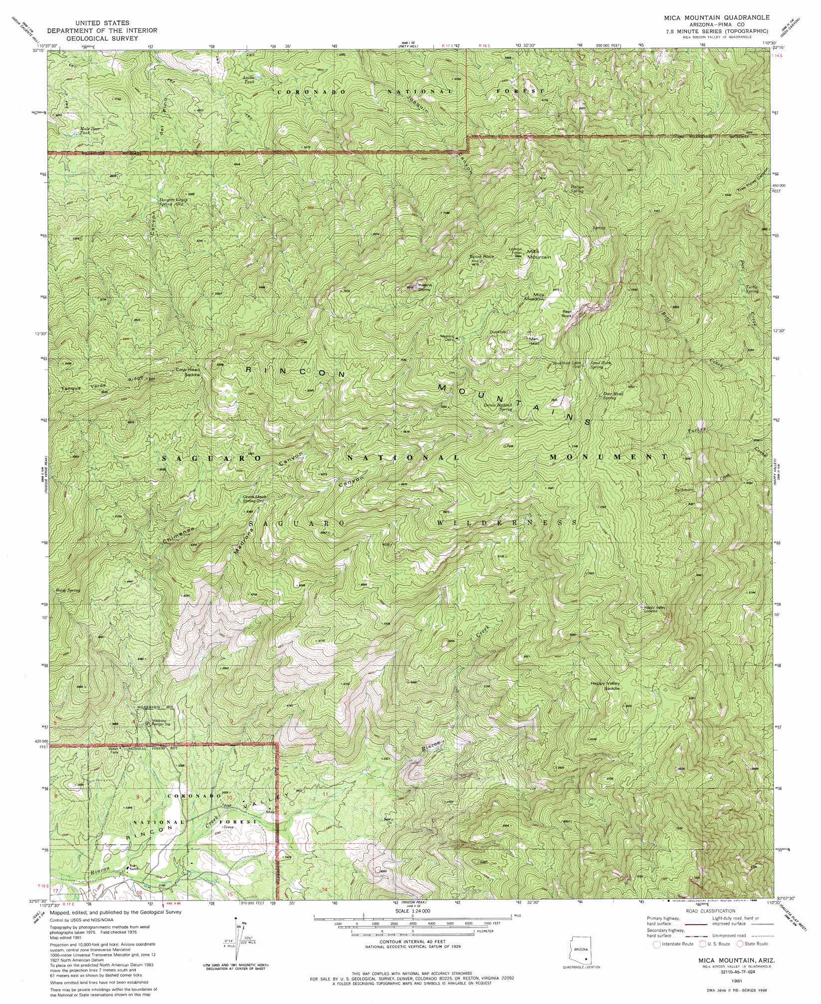
USGS Topo Quad 32110b5 - 1:24,000 scale
| Topo Map Name: | Mica Mountain |
| USGS Topo Quad ID: | 32110b5 |
| Print Size: | ca. 21 1/4" wide x 27" high |
| Southeast Coordinates: | 32.125° N latitude / 110.5° W longitude |
| Map Center Coordinates: | 32.1875° N latitude / 110.5625° W longitude |
| U.S. State: | AZ |
| Filename: | o32110b5.jpg |
| Download Map JPG Image: | Mica Mountain topo map 1:24,000 scale |
| Map Type: | Topographic |
| Topo Series: | 7.5´ |
| Map Scale: | 1:24,000 |
| Source of Map Images: | United States Geological Survey (USGS) |
| Alternate Map Versions: |
Mica Mountain AZ 1981, updated 1981 Download PDF Buy paper map Mica Mountain AZ 1981, updated 1985 Download PDF Buy paper map Mica Mountain AZ 1981, updated 1985 Download PDF Buy paper map Mica Mountain AZ 1996, updated 2002 Download PDF Buy paper map Mica Mountain AZ 2011 Download PDF Buy paper map Mica Mountain AZ 2014 Download PDF Buy paper map |
| FStopo: | US Forest Service topo Mica Mountain is available: Download FStopo PDF Download FStopo TIF |
1:24,000 Topo Quads surrounding Mica Mountain
Mount Lemmon |
Mount Bigelow |
Buehman Canyon |
Redington |
Cherry Spring Peak |
Sabino Canyon |
Agua Caliente Hill |
Piety Hill |
Soza Canyon |
Soza Mesa |
Tucson East |
Tanque Verde Peak |
Mica Mountain |
Happy Valley |
Wildhorse Mountain |
Tucson Se |
Vail |
Rincon Peak |
Galleta Flat West |
Galleta Flat East |
Corona De Tucson |
Mount Fagan |
The Narrows |
Mescal |
Benson |
> Back to 32110a1 at 1:100,000 scale
> Back to 32110a1 at 1:250,000 scale
> Back to U.S. Topo Maps home
Mica Mountain topo map: Gazetteer
Mica Mountain: Flats
Mica Meadow elevation 2549m 8362′Mica Mountain: Gaps
Cow Head Saddle elevation 1877m 6158′Happy Valley Saddle elevation 1915m 6282′
Mica Mountain: Parks
Chimenea Natural Area elevation 1587m 5206′Saguaro National Park East Unit (historical) elevation 1438m 4717′
Mica Mountain: Reservoirs
Anillo Tank elevation 1356m 4448′Mule Deer Tank elevation 1377m 4517′
Mica Mountain: Ridges
Rincon Mountains elevation 2200m 7217′Tanque Verde Ridge elevation 1833m 6013′
Mica Mountain: Springs
Arts Spring elevation 2474m 8116′Cow Head Trail Spring elevation 1428m 4685′
Deer Head Spring elevation 2294m 7526′
Devils Bathtub elevation 2300m 7545′
Douglas Camp Spring elevation 1427m 4681′
Grass Shack Spring elevation 1649m 5410′
Head Trails Springs elevation 1140m 3740′
Italian Spring elevation 2359m 7739′
Spud Rock Spring elevation 2246m 7368′
Turkey Creek Spring elevation 1532m 5026′
Turtle Spring elevation 1670m 5479′
Wasp Spring elevation 1570m 5150′
Mica Mountain: Streams
Sycamore Creek elevation 1438m 4717′Mica Mountain: Summits
Duckbill elevation 2559m 8395′Helens Dome elevation 2430m 7972′
Man Head elevation 2550m 8366′
Mica Mountain elevation 2627m 8618′
Reef Rock elevation 2519m 8264′
Spud Rock elevation 2553m 8375′
Mica Mountain: Trails
Douglas Spring Trail elevation 1427m 4681′Heartbreak Ridge Trail elevation 2183m 7162′
Mica Mountain: Valleys
Chimenea Canyon elevation 991m 3251′Madrona Canyon elevation 994m 3261′
Mica Mountain digital topo map on disk
Buy this Mica Mountain topo map showing relief, roads, GPS coordinates and other geographical features, as a high-resolution digital map file on DVD: