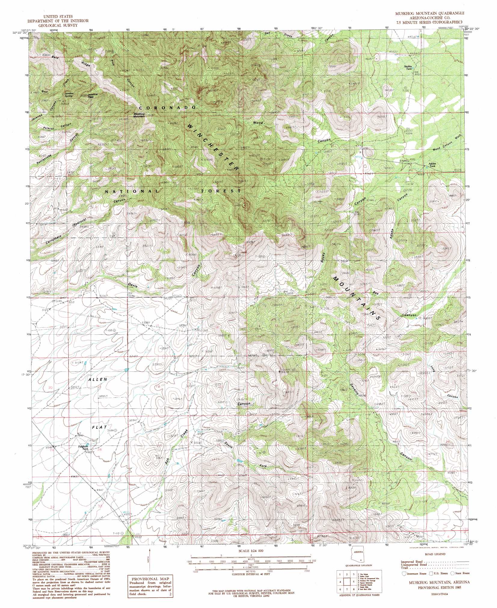
Muskhog Mountain Topo Map Arizona
To zoom in, hover over the map of Muskhog Mountain
USGS Topo Quad 32110c1 - 1:24,000 scale
| Topo Map Name: | Muskhog Mountain |
| USGS Topo Quad ID: | 32110c1 |
| Print Size: | ca. 21 1/4" wide x 27" high |
| Southeast Coordinates: | 32.25° N latitude / 110° W longitude |
| Map Center Coordinates: | 32.3125° N latitude / 110.0625° W longitude |
| U.S. State: | AZ |
| Filename: | o32110c1.jpg |
| Download Map JPG Image: | Muskhog Mountain topo map 1:24,000 scale |
| Map Type: | Topographic |
| Topo Series: | 7.5´ |
| Map Scale: | 1:24,000 |
| Source of Map Images: | United States Geological Survey (USGS) |
| Alternate Map Versions: |
Muskhog Mountain AZ 1985, updated 1985 Download PDF Buy paper map Muskhog Mountain AZ 1996, updated 2002 Download PDF Buy paper map Muskhog Mountain AZ 2011 Download PDF Buy paper map Muskhog Mountain AZ 2014 Download PDF Buy paper map |
| FStopo: | US Forest Service topo Muskhog Mountain is available: Download FStopo PDF Download FStopo TIF |
1:24,000 Topo Quads surrounding Muskhog Mountain
Bassett Peak |
Harrison Canyon |
Sierra Bonita Ranch |
Fort Grant |
Stockton Pass |
Cherry Spring Peak |
The Mesas |
Reiley Peak |
West Of Greasewood Mountain |
Greasewood Mountain |
Soza Mesa |
Hookers Hot Springs |
Muskhog Mountain |
Square Mountain |
Willcox North |
Wildhorse Mountain |
Deepwell Ranch |
Steele Hills |
Red Bird Hills |
Willcox South |
Galleta Flat East |
San Pedro Ranch |
Dragoon |
Cochise |
Sulphur Spring |
> Back to 32110a1 at 1:100,000 scale
> Back to 32110a1 at 1:250,000 scale
> Back to U.S. Topo Maps home
Muskhog Mountain topo map: Gazetteer
Muskhog Mountain: Reservoirs
Adobe Tank elevation 1392m 4566′Cement Dam Tank elevation 1790m 5872′
Fulghum Tank elevation 1527m 5009′
Stubbs Tank elevation 1355m 4445′
Muskhog Mountain: Ridges
Winchester Mountains elevation 2039m 6689′Muskhog Mountain: Springs
Javelina Spring elevation 1854m 6082′Muskhog Mountain: Summits
Javelina Peak elevation 2088m 6850′Muskhog Mountain elevation 2260m 7414′
Muskhog Mountain: Valleys
Adobe Canyon elevation 1427m 4681′Ash Creek Canyon elevation 1513m 4963′
Oak Grove Canyon elevation 1422m 4665′
Rocky Canyon elevation 1427m 4681′
South Fork Canyon elevation 1571m 5154′
Wood Canyon elevation 1990m 6528′
Muskhog Mountain digital topo map on disk
Buy this Muskhog Mountain topo map showing relief, roads, GPS coordinates and other geographical features, as a high-resolution digital map file on DVD: