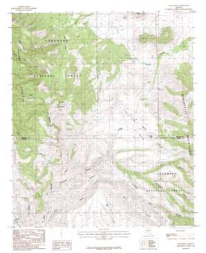
The Mesas Topo Map Arizona
To zoom in, hover over the map of The Mesas
USGS Topo Quad 32110d2 - 1:24,000 scale
| Topo Map Name: | The Mesas |
| USGS Topo Quad ID: | 32110d2 |
| Print Size: | ca. 21 1/4" wide x 27" high |
| Southeast Coordinates: | 32.375° N latitude / 110.125° W longitude |
| Map Center Coordinates: | 32.4375° N latitude / 110.1875° W longitude |
| U.S. State: | AZ |
| Filename: | o32110d2.jpg |
| Download Map JPG Image: | The Mesas topo map 1:24,000 scale |
| Map Type: | Topographic |
| Topo Series: | 7.5´ |
| Map Scale: | 1:24,000 |
| Source of Map Images: | United States Geological Survey (USGS) |
| Alternate Map Versions: |
The Mesas AZ 1985, updated 1985 Download PDF Buy paper map The Mesas AZ 1985, updated 1985 Download PDF Buy paper map The Mesas AZ 1996, updated 2003 Download PDF Buy paper map The Mesas AZ 2011 Download PDF Buy paper map The Mesas AZ 2014 Download PDF Buy paper map |
| FStopo: | US Forest Service topo The Mesas is available: Download FStopo PDF Download FStopo TIF |
1:24,000 Topo Quads surrounding The Mesas
> Back to 32110a1 at 1:100,000 scale
> Back to 32110a1 at 1:250,000 scale
> Back to U.S. Topo Maps home
The Mesas topo map: Gazetteer
The Mesas: Ranges
Galiuro Mountains elevation 1885m 6184′The Mesas: Reservoirs
Bald Ridge Number One Tank elevation 1762m 5780′Bass Tank elevation 1629m 5344′
Boundary Tank elevation 1609m 5278′
Brush Tank elevation 1715m 5626′
Burro Tank elevation 1568m 5144′
Cave Tank elevation 1562m 5124′
Channel Tank elevation 1657m 5436′
Deer Tanks elevation 1509m 4950′
Eagle Tanks elevation 1643m 5390′
Ice Box Tank elevation 1573m 5160′
Juniper Tank elevation 1707m 5600′
Larson Tank elevation 1487m 4878′
Larson Tank elevation 1487m 4878′
Little Red Tank elevation 1558m 5111′
Little Tank elevation 1524m 5000′
Middle Tank elevation 1521m 4990′
Negro Tank elevation 1580m 5183′
New Tank elevation 1608m 5275′
Pancho Tank elevation 1546m 5072′
Pine Canyon Tank elevation 1653m 5423′
Reiley Tank elevation 1813m 5948′
Rock House Tank elevation 1605m 5265′
Rock Tank elevation 1587m 5206′
Saddle Mountain Tank elevation 1583m 5193′
Saddle Tank elevation 1522m 4993′
Sand Tank elevation 1514m 4967′
Seep Tank elevation 1560m 5118′
Wear Tank elevation 1492m 4895′
Whalen Tank elevation 1605m 5265′
The Mesas: Ridges
Bald Ridge elevation 1797m 5895′Pine Ridge elevation 1662m 5452′
The Mesas: Springs
Bear Spring elevation 1628m 5341′Box Spring elevation 1442m 4730′
Double R Springs elevation 1318m 4324′
Poer Spring elevation 1815m 5954′
The Mesas: Summits
Saddle Mountain elevation 0m 0′The Mesas elevation 1638m 5374′
The Mesas: Valleys
Bear Canyon elevation 1502m 4927′Brush Canyon elevation 1611m 5285′
East Fork Bass Canyon elevation 1366m 4481′
Pine Canyon elevation 1339m 4393′
Redus Canyon elevation 1368m 4488′
Rockhouse Canyon elevation 1363m 4471′
Seeps Canyon elevation 1450m 4757′
West Fork Bass Canyon elevation 1316m 4317′
The Mesas digital topo map on disk
Buy this The Mesas topo map showing relief, roads, GPS coordinates and other geographical features, as a high-resolution digital map file on DVD:


