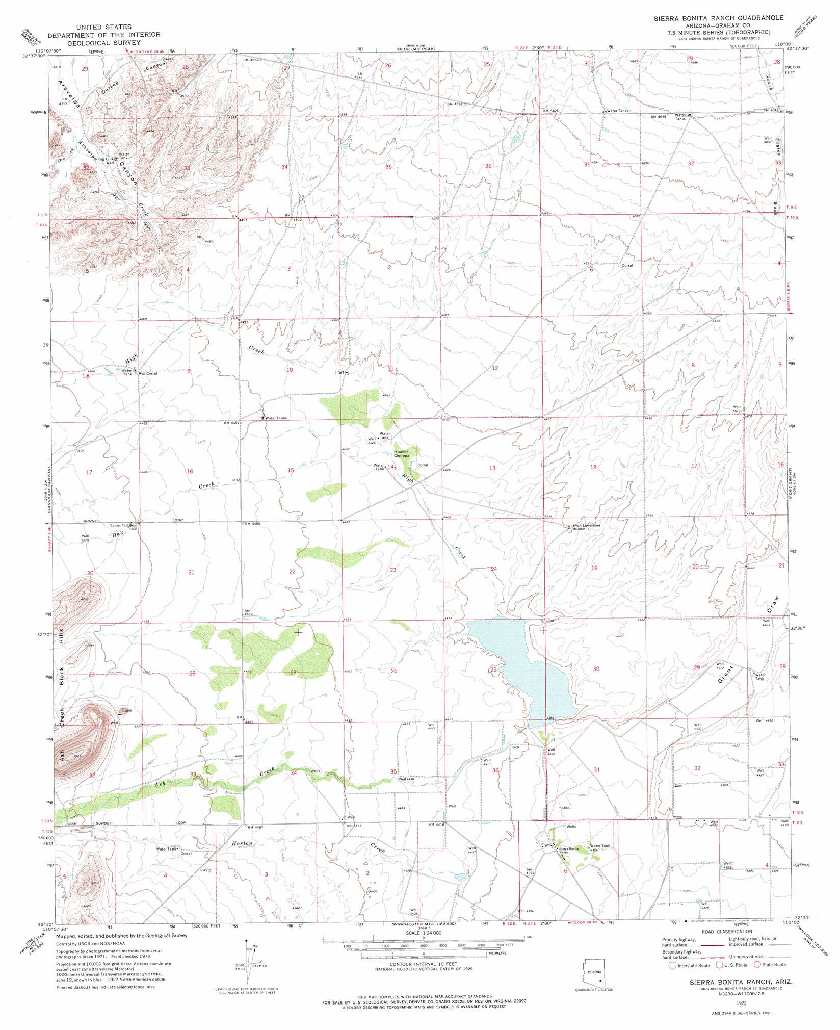
Sierra Bonita Ranch Topo Map Arizona
To zoom in, hover over the map of Sierra Bonita Ranch
USGS Topo Quad 32110e1 - 1:24,000 scale
| Topo Map Name: | Sierra Bonita Ranch |
| USGS Topo Quad ID: | 32110e1 |
| Print Size: | ca. 21 1/4" wide x 27" high |
| Southeast Coordinates: | 32.5° N latitude / 110° W longitude |
| Map Center Coordinates: | 32.5625° N latitude / 110.0625° W longitude |
| U.S. State: | AZ |
| Filename: | o32110e1.jpg |
| Download Map JPG Image: | Sierra Bonita Ranch topo map 1:24,000 scale |
| Map Type: | Topographic |
| Topo Series: | 7.5´ |
| Map Scale: | 1:24,000 |
| Source of Map Images: | United States Geological Survey (USGS) |
| Alternate Map Versions: |
Sierra Bonita Ranch AZ 1972, updated 1975 Download PDF Buy paper map Sierra Bonita Ranch AZ 2011 Download PDF Buy paper map Sierra Bonita Ranch AZ 2014 Download PDF Buy paper map |
| FStopo: | US Forest Service topo Sierra Bonita Ranch is available: Download FStopo PDF Download FStopo TIF |
1:24,000 Topo Quads surrounding Sierra Bonita Ranch
Klondike |
Buford Hill |
Tripp Canyon |
Shingle Mill Mountain |
Thatcher |
Kennedy Peak |
Eureka Ranch |
Blue Jay Peak |
Webb Peak |
Mount Graham |
Bassett Peak |
Harrison Canyon |
Sierra Bonita Ranch |
Fort Grant |
Stockton Pass |
Cherry Spring Peak |
The Mesas |
Reiley Peak |
West Of Greasewood Mountain |
Greasewood Mountain |
Soza Mesa |
Hookers Hot Springs |
Muskhog Mountain |
Square Mountain |
Willcox North |
> Back to 32110e1 at 1:100,000 scale
> Back to 32110a1 at 1:250,000 scale
> Back to U.S. Topo Maps home
Sierra Bonita Ranch topo map: Gazetteer
Sierra Bonita Ranch: Flats
Hooker Cienega elevation 1349m 4425′Sierra Bonita Ranch: Streams
Ash Creek elevation 1340m 4396′Harrison Creek elevation 1316m 4317′
High Creek elevation 1342m 4402′
Horton Creek elevation 1343m 4406′
Oak Creek elevation 1348m 4422′
South Taylor Wash elevation 1354m 4442′
Sierra Bonita Ranch: Valleys
Durkee Canyon elevation 1320m 4330′Grant Draw elevation 1338m 4389′
Sierra Bonita Ranch: Wells
Big Tank Well elevation 1327m 4353′Sierra Bonita Ranch digital topo map on disk
Buy this Sierra Bonita Ranch topo map showing relief, roads, GPS coordinates and other geographical features, as a high-resolution digital map file on DVD: