Oracle Junction Topo Map Arizona
To zoom in, hover over the map of Oracle Junction
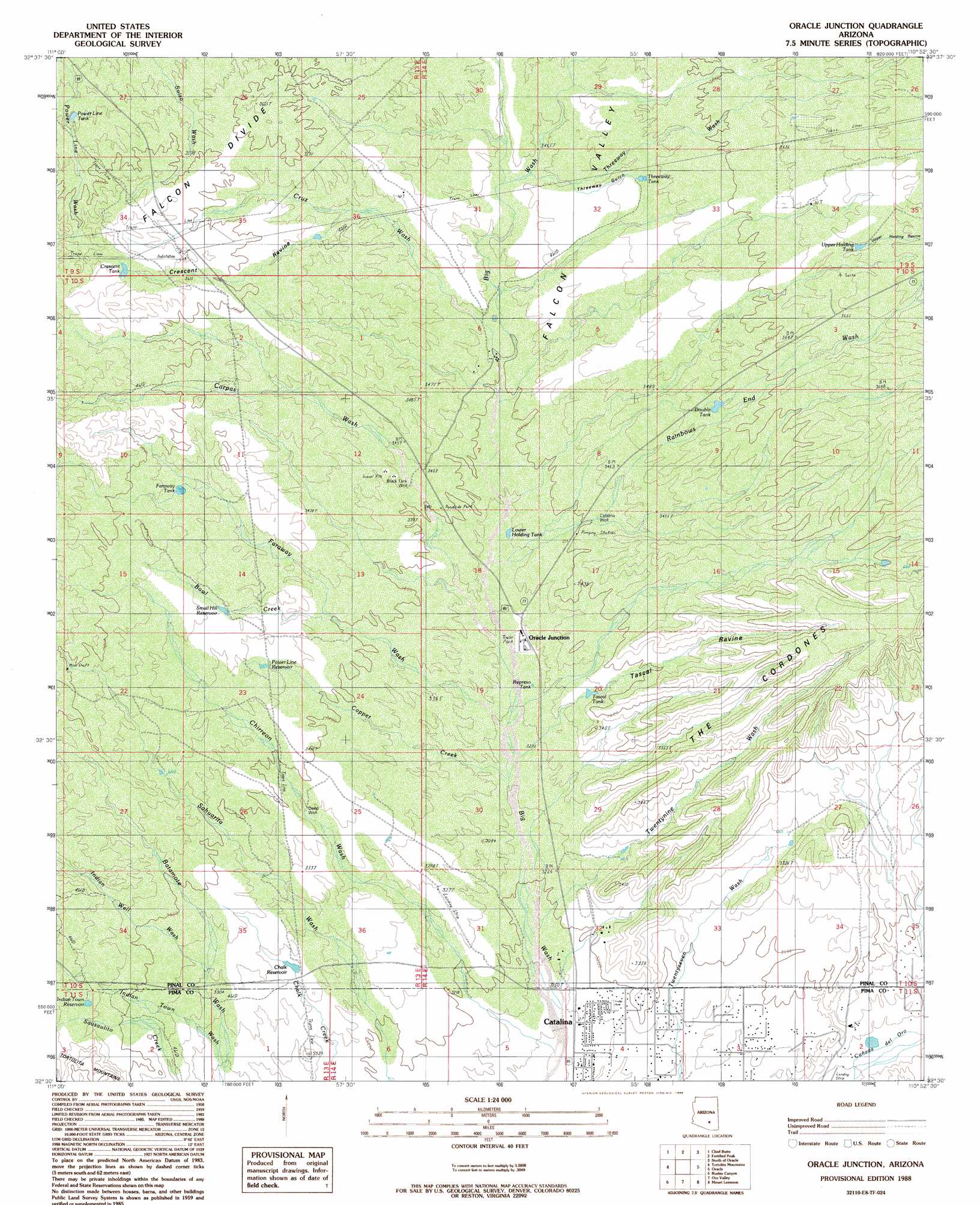
USGS Topo Quad 32110e8 - 1:24,000 scale
| Topo Map Name: | Oracle Junction |
| USGS Topo Quad ID: | 32110e8 |
| Print Size: | ca. 21 1/4" wide x 27" high |
| Southeast Coordinates: | 32.5° N latitude / 110.875° W longitude |
| Map Center Coordinates: | 32.5625° N latitude / 110.9375° W longitude |
| U.S. State: | AZ |
| Filename: | o32110e8.jpg |
| Download Map JPG Image: | Oracle Junction topo map 1:24,000 scale |
| Map Type: | Topographic |
| Topo Series: | 7.5´ |
| Map Scale: | 1:24,000 |
| Source of Map Images: | United States Geological Survey (USGS) |
| Alternate Map Versions: |
Oracle Junction AZ 1988, updated 1989 Download PDF Buy paper map Oracle Junction AZ 1988, updated 1989 Download PDF Buy paper map Oracle Junction AZ 1996, updated 2002 Download PDF Buy paper map Oracle Junction AZ 2011 Download PDF Buy paper map Oracle Junction AZ 2014 Download PDF Buy paper map |
1:24,000 Topo Quads surrounding Oracle Junction
Ninetysix Hills Sw |
Ninetysix Hills Se |
Black Mountain |
Putnam Wash |
Lookout Mountain |
Durham Hills |
Chief Butte |
Fortified Peak |
North Of Oracle |
Mammoth |
Desert Peak |
Tortolita Mountains |
Oracle Junction |
Oracle |
Campo Bonito |
Marana |
Ruelas Canyon |
Oro Valley |
Mount Lemmon |
Mount Bigelow |
Avra |
Jaynes |
Tucson North |
Sabino Canyon |
Agua Caliente Hill |
> Back to 32110e1 at 1:100,000 scale
> Back to 32110a1 at 1:250,000 scale
> Back to U.S. Topo Maps home
Oracle Junction topo map: Gazetteer
Oracle Junction: Airports
Martin Ranch Airstrip elevation 992m 3254′Oracle Junction: Arroyos
Upper Holding Ravine elevation 1025m 3362′Oracle Junction: Dams
Lower Sahuarita Dam (historical) elevation 1051m 3448′Upper Sahuarita Dam elevation 1080m 3543′
Oracle Junction: Populated Places
Catalina elevation 962m 3156′Oracle Junction elevation 1012m 3320′
Oracle Junction: Reservoirs
Chalk Reservoir elevation 1002m 3287′Crescent Tank elevation 1118m 3667′
Double Tank elevation 1080m 3543′
Faraway Tank elevation 1076m 3530′
Indian Town Reservoir elevation 1051m 3448′
Lower Holding Tank elevation 1024m 3359′
Power Line Reservoir elevation 1051m 3448′
Power Line Tank elevation 1074m 3523′
Represo Tank elevation 1006m 3300′
Small Hill Reservoir elevation 1063m 3487′
Tascal Tank elevation 1017m 3336′
Threeway Tank elevation 1080m 3543′
Upper Holding Tank elevation 1122m 3681′
Oracle Junction: Ridges
Falcon Divide elevation 1102m 3615′Oracle Junction: Streams
Bowl Creek elevation 1037m 3402′Carpas Wash elevation 999m 3277′
Chirreon Wash elevation 950m 3116′
Copper Creek elevation 990m 3248′
Cruz Wash elevation 1039m 3408′
Faraway Wash elevation 999m 3277′
Indian Well Wash elevation 1012m 3320′
Rainbows End Wash elevation 1037m 3402′
Threeway Wash elevation 1056m 3464′
Twentynine Wash elevation 971m 3185′
Oracle Junction: Summits
The Cordones elevation 1080m 3543′Oracle Junction: Valleys
Crescent Ravine elevation 1071m 3513′Falcon Valley elevation 1041m 3415′
Fox Ravine (historical) elevation 1015m 3330′
Tascal Ravine elevation 1012m 3320′
Threeway Gulch elevation 1060m 3477′
Oracle Junction: Wells
Black Tank Well elevation 1045m 3428′Catalina Well elevation 1038m 3405′
Deep Well elevation 1024m 3359′
Walnut Well elevation 1009m 3310′
Well Twentynine elevation 996m 3267′
Well Twentyseven elevation 1011m 3316′
Oracle Junction digital topo map on disk
Buy this Oracle Junction topo map showing relief, roads, GPS coordinates and other geographical features, as a high-resolution digital map file on DVD: