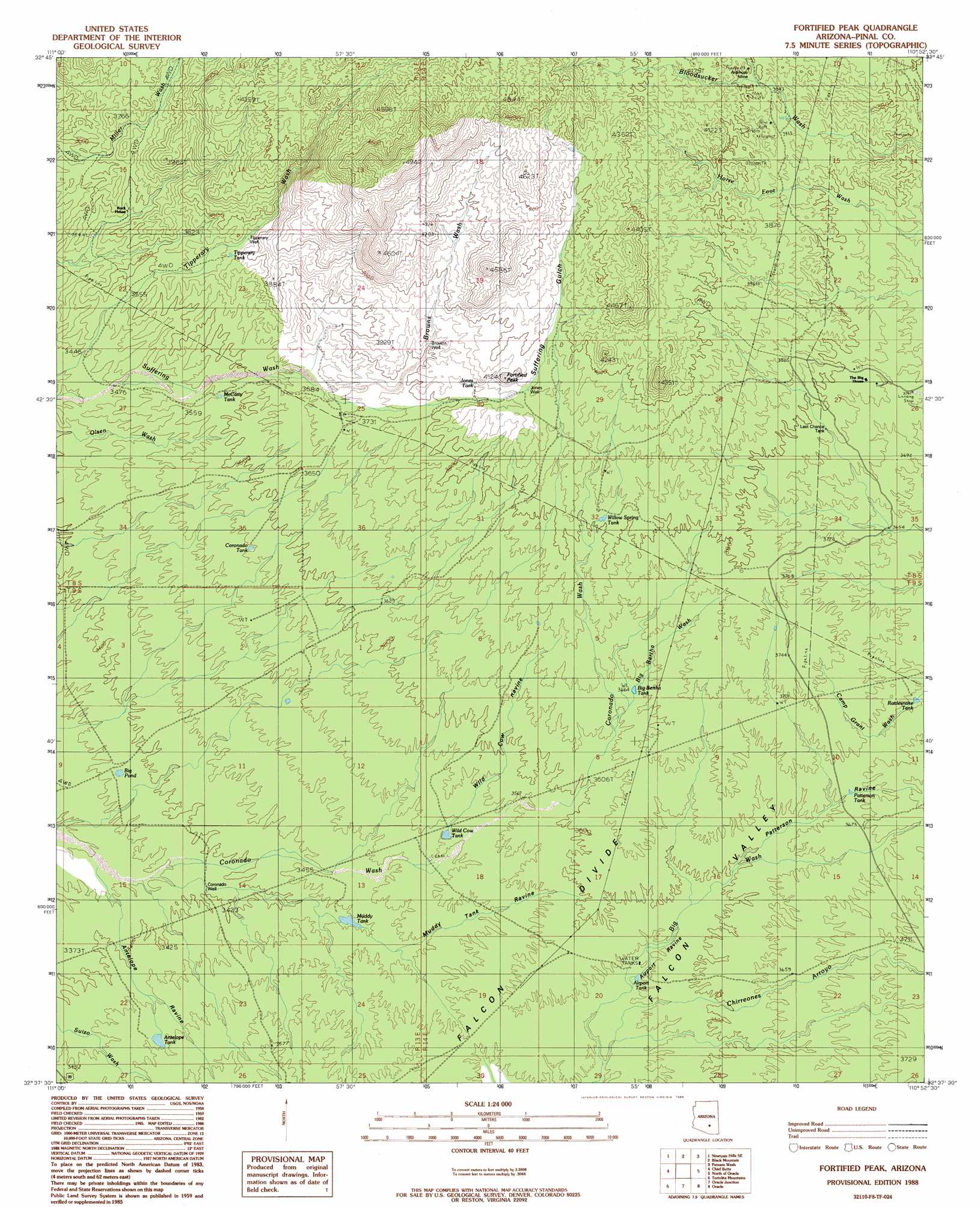
Fortified Peak Topo Map Arizona
To zoom in, hover over the map of Fortified Peak
USGS Topo Quad 32110f8 - 1:24,000 scale
| Topo Map Name: | Fortified Peak |
| USGS Topo Quad ID: | 32110f8 |
| Print Size: | ca. 21 1/4" wide x 27" high |
| Southeast Coordinates: | 32.625° N latitude / 110.875° W longitude |
| Map Center Coordinates: | 32.6875° N latitude / 110.9375° W longitude |
| U.S. State: | AZ |
| Filename: | o32110f8.jpg |
| Download Map JPG Image: | Fortified Peak topo map 1:24,000 scale |
| Map Type: | Topographic |
| Topo Series: | 7.5´ |
| Map Scale: | 1:24,000 |
| Source of Map Images: | United States Geological Survey (USGS) |
| Alternate Map Versions: |
Fortified Peak AZ 1988, updated 1989 Download PDF Buy paper map Fortified Peak AZ 1996, updated 2003 Download PDF Buy paper map Fortified Peak AZ 2011 Download PDF Buy paper map Fortified Peak AZ 2014 Download PDF Buy paper map |
1:24,000 Topo Quads surrounding Fortified Peak
Ninetysix Hills Nw |
Ninetysix Hills Ne |
Crozier Peak |
Winkelman |
Dudleyville |
Ninetysix Hills Sw |
Ninetysix Hills Se |
Black Mountain |
Putnam Wash |
Lookout Mountain |
Durham Hills |
Chief Butte |
Fortified Peak |
North Of Oracle |
Mammoth |
Desert Peak |
Tortolita Mountains |
Oracle Junction |
Oracle |
Campo Bonito |
Marana |
Ruelas Canyon |
Oro Valley |
Mount Lemmon |
Mount Bigelow |
> Back to 32110e1 at 1:100,000 scale
> Back to 32110a1 at 1:250,000 scale
> Back to U.S. Topo Maps home
Fortified Peak topo map: Gazetteer
Fortified Peak: Lakes
Big Pond elevation 1028m 3372′Fortified Peak: Mines
Ardmore Mine elevation 1220m 4002′Hot Boy Mine elevation 1198m 3930′
Fortified Peak: Reservoirs
Airport Tank elevation 1082m 3549′Antelope Tank elevation 1059m 3474′
Big Bertha Tank elevation 1119m 3671′
Coronado Tank elevation 1086m 3562′
Jones Tank elevation 1172m 3845′
Last Chance Tank elevation 1147m 3763′
McCarty Tank elevation 1089m 3572′
Muddy Tank elevation 1045m 3428′
Patterson Tank elevation 1112m 3648′
Rattlesnake Tank elevation 1110m 3641′
Tipperary Tank elevation 1132m 3713′
Wild Cow Tank elevation 1074m 3523′
Willow Spring Tank elevation 1159m 3802′
Fortified Peak: Streams
Big Bertha Wash elevation 1119m 3671′Browns Wash elevation 1134m 3720′
Fortified Peak: Summits
Fortified Peak elevation 1224m 4015′Fortified Peak: Valleys
Airport Ravine elevation 1086m 3562′Antelope Ravine elevation 1024m 3359′
Chirreones Arroyo elevation 1091m 3579′
Muddy Tank Ravine elevation 1034m 3392′
Patterson Ravine elevation 1098m 3602′
Suffering Gulch elevation 1198m 3930′
Wild Cow Ravine elevation 1071m 3513′
Fortified Peak: Wells
Browns Well elevation 1171m 3841′Coronado Well elevation 1028m 3372′
James Well elevation 1183m 3881′
Jones Well elevation 1188m 3897′
Tipperary Well elevation 1137m 3730′
Fortified Peak digital topo map on disk
Buy this Fortified Peak topo map showing relief, roads, GPS coordinates and other geographical features, as a high-resolution digital map file on DVD: