Aztec Nw Topo Map Arizona
To zoom in, hover over the map of Aztec Nw
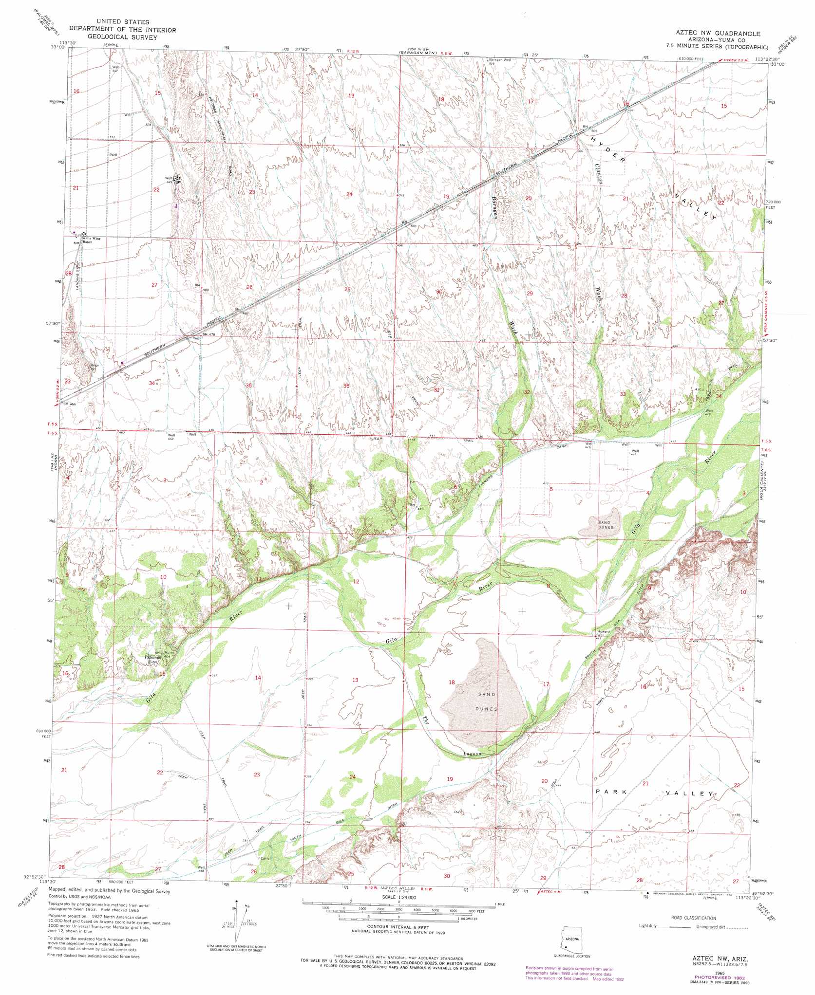
USGS Topo Quad 32113h4 - 1:24,000 scale
| Topo Map Name: | Aztec Nw |
| USGS Topo Quad ID: | 32113h4 |
| Print Size: | ca. 21 1/4" wide x 27" high |
| Southeast Coordinates: | 32.875° N latitude / 113.375° W longitude |
| Map Center Coordinates: | 32.9375° N latitude / 113.4375° W longitude |
| U.S. State: | AZ |
| Filename: | o32113h4.jpg |
| Download Map JPG Image: | Aztec Nw topo map 1:24,000 scale |
| Map Type: | Topographic |
| Topo Series: | 7.5´ |
| Map Scale: | 1:24,000 |
| Source of Map Images: | United States Geological Survey (USGS) |
| Alternate Map Versions: |
Aztec NW AZ 1965, updated 1966 Download PDF Buy paper map Aztec NW AZ 1965, updated 1977 Download PDF Buy paper map Aztec NW AZ 1965, updated 1982 Download PDF Buy paper map Aztec NW AZ 2011 Download PDF Buy paper map Aztec NW AZ 2014 Download PDF Buy paper map |
1:24,000 Topo Quads surrounding Aztec Nw
Palomas Mountains Nw |
Palomas Mountains Ne |
Turtleback Mountain |
Hyder Ne |
Yellow Medicine Butte |
Palomas Mountains Sw |
Palomas Mountains Se |
Baragan Mountain |
Hyder |
Oatman Mountain |
Kofa |
Horn |
Aztec Nw |
Agua Caliente |
Sentinel Peak |
Texas Hill |
Dateland |
Aztec Hills |
Aztec Se |
Sentinel |
Mohawk Mountains Nw |
Hohawk Mountains Ne |
Aguila Mountains Nw |
Aguila Mountains Ne |
South Of Sentinel |
> Back to 32113e1 at 1:100,000 scale
> Back to 32112a1 at 1:250,000 scale
> Back to U.S. Topo Maps home
Aztec Nw topo map: Gazetteer
Aztec Nw: Canals
Farmers Canal elevation 127m 416′Aztec Nw: Cliffs
Sears Point elevation 0m 0′Aztec Nw: Populated Places
Palomas elevation 124m 406′Aztec Nw: Streams
Baragan Wash elevation 123m 403′Clanton Wash elevation 128m 419′
The Lagoon elevation 120m 393′
Aztec Nw: Valleys
Park Valley elevation 137m 449′Aztec Nw: Wells
Baragan Well elevation 162m 531′Howard Well elevation 124m 406′
Aztec Nw digital topo map on disk
Buy this Aztec Nw topo map showing relief, roads, GPS coordinates and other geographical features, as a high-resolution digital map file on DVD: