Somerton Topo Map Arizona
To zoom in, hover over the map of Somerton
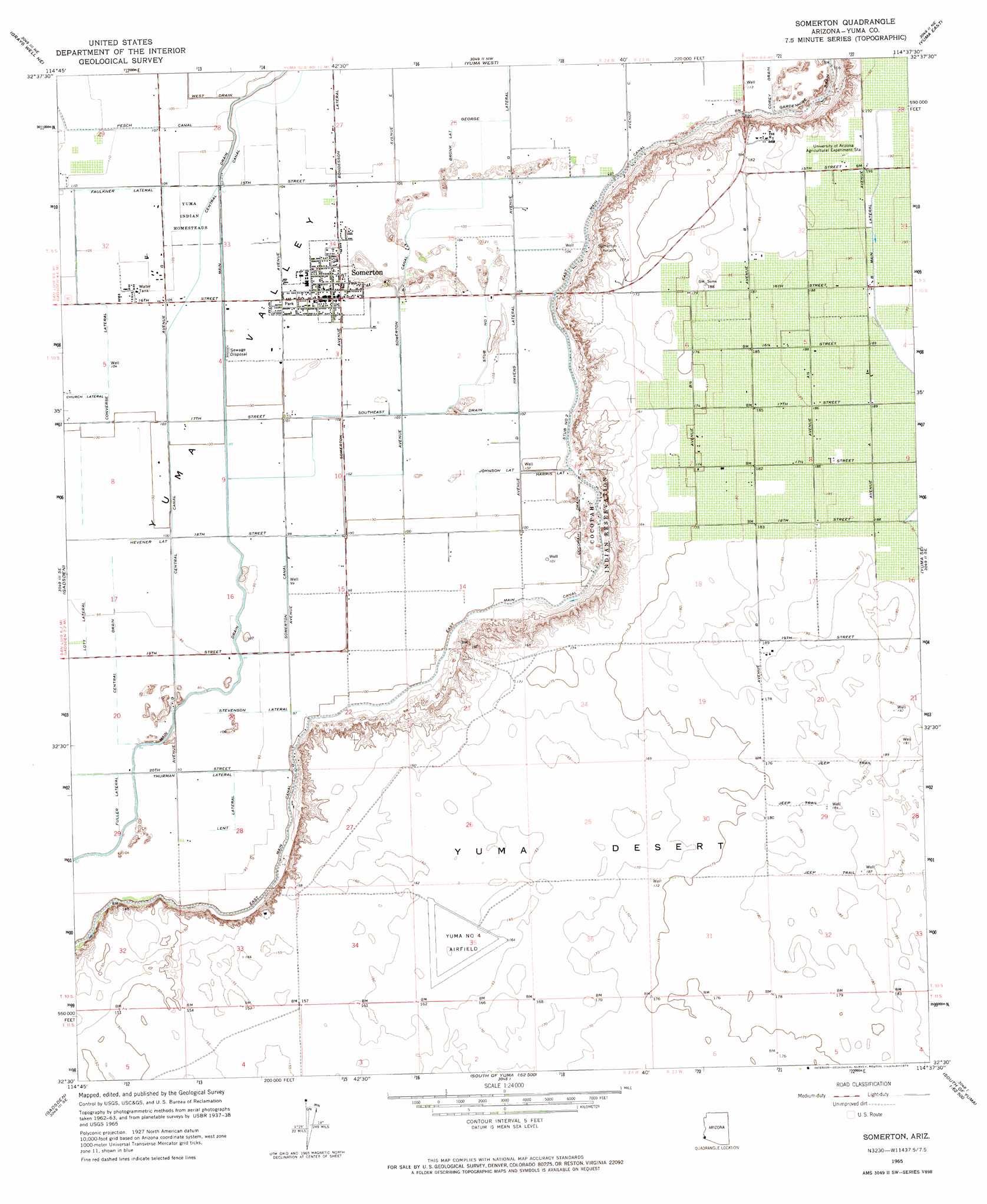
USGS Topo Quad 32114e6 - 1:24,000 scale
| Topo Map Name: | Somerton |
| USGS Topo Quad ID: | 32114e6 |
| Print Size: | ca. 21 1/4" wide x 27" high |
| Southeast Coordinates: | 32.5° N latitude / 114.625° W longitude |
| Map Center Coordinates: | 32.5625° N latitude / 114.6875° W longitude |
| U.S. State: | AZ |
| Filename: | o32114e6.jpg |
| Download Map JPG Image: | Somerton topo map 1:24,000 scale |
| Map Type: | Topographic |
| Topo Series: | 7.5´ |
| Map Scale: | 1:24,000 |
| Source of Map Images: | United States Geological Survey (USGS) |
| Alternate Map Versions: |
Somerton AZ 1965, updated 1966 Download PDF Buy paper map Somerton AZ 1965, updated 1974 Download PDF Buy paper map Somerton AZ 2011 Download PDF Buy paper map Somerton AZ 2014 Download PDF Buy paper map |
1:24,000 Topo Quads surrounding Somerton
Cactus |
Ogilby |
Araz |
Bard |
Laguna Dam |
Grays Well |
Grays Well Ne |
Yuma West |
Yuma East |
Fortuna |
Somerton |
Yuma Se |
Fortuna Sw |
||
South Of Somerton |
Southeast Of Somerton |
West Of Vopoki Ridge |
||
> Back to 32114e1 at 1:100,000 scale
> Back to 32114a1 at 1:250,000 scale
> Back to U.S. Topo Maps home
Somerton topo map: Gazetteer
Somerton: Airports
Checkerboard Airport elevation 58m 190′Rolle Airfield elevation 50m 164′
Somerton Airport elevation 54m 177′
Yuma Number Four Airfield elevation 51m 167′
Somerton: Canals
Abbott Lateral elevation 31m 101′B Main Lateral elevation 59m 193′
Bondesson Lateral elevation 33m 108′
Bronk Lateral elevation 33m 108′
Cahoon Lateral elevation 30m 98′
Carter Lateral elevation 29m 95′
Case Lateral elevation 31m 101′
Central Drain elevation 29m 95′
Church Lateral elevation 31m 101′
Cocopah Drain elevation 33m 108′
Converse Lateral elevation 32m 104′
Corey Drain elevation 34m 111′
East Hearn Lateral elevation 28m 91′
Faulkner Lateral elevation 34m 111′
Fishbaugh Lateral elevation 33m 108′
Franklin Lateral elevation 32m 104′
Fuller Lateral elevation 28m 91′
Garven Lateral elevation 32m 104′
Graham Lateral elevation 33m 108′
Harris Lateral elevation 31m 101′
Havens Lateral elevation 32m 104′
Hearn Lateral elevation 31m 101′
Hevener Lateral elevation 31m 101′
Johnson Lateral elevation 31m 101′
Lateral B-2 elevation 59m 193′
Lent Lateral elevation 29m 95′
Main Drain elevation 30m 98′
Main Lateral elevation 59m 193′
Molina Lateral elevation 30m 98′
Shields Lateral elevation 30m 98′
Somerton Canal elevation 33m 108′
Somerton Lateral elevation 32m 104′
Somerton Lateral Wasteway elevation 30m 98′
Southeast Drain elevation 32m 104′
Stevenson Lateral elevation 29m 95′
Stub Number One elevation 31m 101′
Stub Number Two elevation 33m 108′
Thurman Lateral elevation 28m 91′
Trevorrow Lateral elevation 30m 98′
Tuttle Lateral elevation 31m 101′
West Drain elevation 33m 108′
West Hearn Lateral elevation 28m 91′
White Lateral elevation 34m 111′
Somerton: Parks
Somerton Park elevation 31m 101′Somerton: Populated Places
Somerton elevation 32m 104′Somerton: Post Offices
Somerton Post Office elevation 32m 104′Somerton: Summits
Mohawk Peak elevation 57m 187′Somerton digital topo map on disk
Buy this Somerton topo map showing relief, roads, GPS coordinates and other geographical features, as a high-resolution digital map file on DVD: