Bonds Corner Topo Map California
To zoom in, hover over the map of Bonds Corner
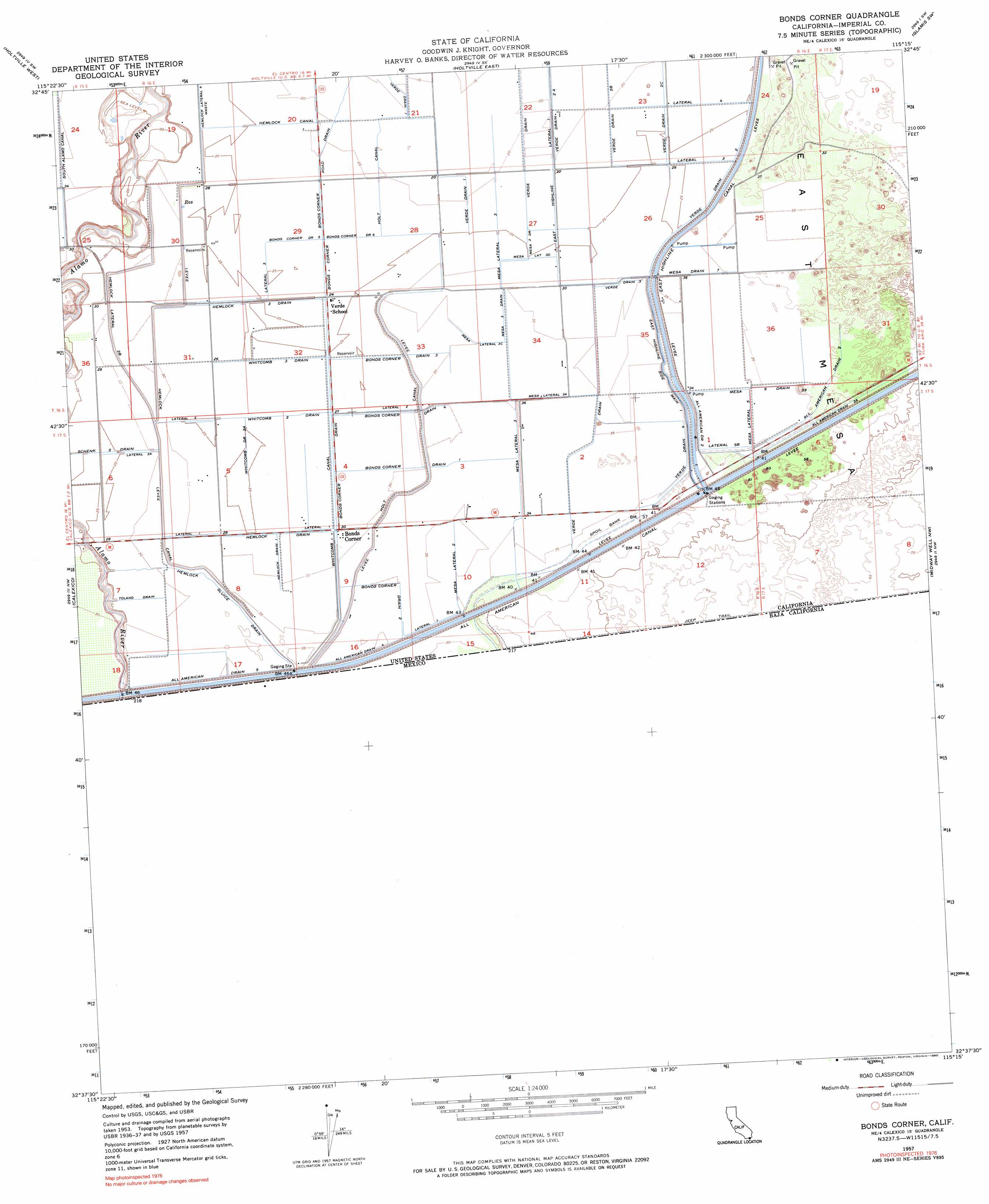
USGS Topo Quad 32115f3 - 1:24,000 scale
| Topo Map Name: | Bonds Corner |
| USGS Topo Quad ID: | 32115f3 |
| Print Size: | ca. 21 1/4" wide x 27" high |
| Southeast Coordinates: | 32.625° N latitude / 115.25° W longitude |
| Map Center Coordinates: | 32.6875° N latitude / 115.3125° W longitude |
| U.S. State: | CA |
| Filename: | o32115f3.jpg |
| Download Map JPG Image: | Bonds Corner topo map 1:24,000 scale |
| Map Type: | Topographic |
| Topo Series: | 7.5´ |
| Map Scale: | 1:24,000 |
| Source of Map Images: | United States Geological Survey (USGS) |
| Alternate Map Versions: |
Bonds Corner CA 1957, updated 1959 Download PDF Buy paper map Bonds Corner CA 1957, updated 1974 Download PDF Buy paper map Bonds Corner CA 1957, updated 1990 Download PDF Buy paper map Bonds Corner CA 2012 Download PDF Buy paper map Bonds Corner CA 2015 Download PDF Buy paper map |
1:24,000 Topo Quads surrounding Bonds Corner
Brawley |
Alamorio |
Holtville Ne |
Glamis Nw |
Glamis |
El Centro |
Holtville West |
Holtville East |
Glamis Sw |
Glamis Se |
Heber |
Calexico |
Bonds Corner |
Midway Well Nw |
Midway Well |
> Back to 32115e1 at 1:100,000 scale
> Back to 32114a1 at 1:250,000 scale
> Back to U.S. Topo Maps home
Bonds Corner topo map: Gazetteer
Bonds Corner: Canals
All American Drain Five elevation 12m 39′All American Drain Four elevation 13m 42′
All American Drain Two elevation 11m 36′
All American Drain Two elevation 13m 42′
Bonds Corner Drain elevation 7m 22′
Bonds Corner Drain Five elevation 8m 26′
Bonds Corner Drain Four elevation 10m 32′
Bonds Corner Drain One elevation 10m 32′
Bonds Corner Drain Six elevation 8m 26′
Bonds Corner Drain Three elevation 9m 29′
Bonds Corner Drain Two elevation 11m 36′
East Highline Lateral One elevation 7m 22′
East Highline Side Main One elevation 11m 36′
Hemlock Canal elevation 10m 32′
Hemlock Drain elevation 9m 29′
Hemlock Drain One elevation 10m 32′
Hemlock Lateral Four Waste elevation 9m 29′
Hemlock Lateral Two B elevation 10m 32′
Hemlock Sluice Drain elevation 11m 36′
Hemlock Three Drain elevation 8m 26′
Holt Canal elevation 10m 32′
Holt Canal elevation 7m 22′
Lateral Five B elevation 11m 36′
Lateral Four elevation 8m 26′
Lateral One elevation 10m 32′
Lateral One elevation 11m 36′
Lateral One elevation 10m 32′
Lateral Three elevation 8m 26′
Lateral Three elevation 9m 29′
Lateral Two elevation 8m 26′
Lateral Two elevation 10m 32′
Lateral Two A elevation 10m 32′
Mesa Drain Seven elevation 11m 36′
Mesa Lateral Five elevation 12m 39′
Mesa Lateral Three elevation 9m 29′
Mesa Lateral Three A elevation 11m 36′
Mesa Lateral Three C elevation 10m 32′
Mesa Lateral Three D elevation 9m 29′
Mesa Lateral Two elevation 11m 36′
Mesa Six Drain elevation 11m 36′
Mesa Three Drain elevation 10m 32′
Mesa Three Drain elevation 8m 26′
Schenk Two Drain elevation 8m 26′
Toland Drain elevation 9m 29′
Verde Drain elevation 7m 22′
Verde Drain Four elevation 11m 36′
Verde Drain One elevation 7m 22′
Verde Drain Three elevation 9m 29′
Verde Drain Two elevation 10m 32′
Verde Drain Two A elevation 7m 22′
Verde Drain Two B elevation 7m 22′
Verde Drain Two C elevation 8m 26′
Whitcomb Canal elevation 9m 29′
Whitcomb Drain Two A elevation 8m 26′
Whitcomb Three Drain elevation 9m 29′
Whitcomb Two Drain elevation 9m 29′
Bonds Corner: Populated Places
Bonds Corner elevation 10m 32′Bonds Corner digital topo map on disk
Buy this Bonds Corner topo map showing relief, roads, GPS coordinates and other geographical features, as a high-resolution digital map file on DVD: