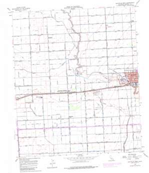
Holtville West Topo Map California
To zoom in, hover over the map of Holtville West
USGS Topo Quad 32115g4 - 1:24,000 scale
| Topo Map Name: | Holtville West |
| USGS Topo Quad ID: | 32115g4 |
| Print Size: | ca. 21 1/4" wide x 27" high |
| Southeast Coordinates: | 32.75° N latitude / 115.375° W longitude |
| Map Center Coordinates: | 32.8125° N latitude / 115.4375° W longitude |
| U.S. State: | CA |
| Filename: | o32115g4.jpg |
| Download Map JPG Image: | Holtville West topo map 1:24,000 scale |
| Map Type: | Topographic |
| Topo Series: | 7.5´ |
| Map Scale: | 1:24,000 |
| Source of Map Images: | United States Geological Survey (USGS) |
| Alternate Map Versions: |
Holtville West CA 1956, updated 1958 Download PDF Buy paper map Holtville West CA 1956, updated 1976 Download PDF Buy paper map Holtville West CA 1956, updated 1979 Download PDF Buy paper map Holtville West CA 1956, updated 1979 Download PDF Buy paper map Holtville West CA 2012 Download PDF Buy paper map Holtville West CA 2015 Download PDF Buy paper map |
1:24,000 Topo Quads surrounding Holtville West
> Back to 32115e1 at 1:100,000 scale
> Back to 32114a1 at 1:250,000 scale
> Back to U.S. Topo Maps home
Holtville West topo map: Gazetteer
Holtville West: Bridges
McKim Bridge elevation -34m -112′Holtville West: Canals
Acacia Canal elevation -5m -17′Acacia Drain elevation -7m -23′
Acacia Five A Drain elevation -10m -33′
Acacia FIve B Drain elevation -10m -33′
Acacia Five Drain elevation -4m -14′
Acacia Lateral Eight elevation -12m -40′
Acacia Lateral Five elevation -7m -23′
Acacia Lateral Five A elevation -9m -30′
Acacia Lateral Four elevation -5m -17′
Acacia Lateral Nine elevation -18m -60′
Acacia Lateral Six elevation -10m -33′
Acacia Lateral Six A elevation -11m -37′
Acacia Lateral Ten elevation -14m -46′
Acacia Lateral Three elevation -4m -14′
Acacia Twelve Lateral elevation -16m -53′
Acacia Twelve Lateral elevation -18m -60′
Ash Drain elevation -1m -4′
Ash Drain Thirtyseven elevation -7m -23′
Ash Fifteen Drain elevation 0m 0′
Ash Lateral Fifteen elevation -1m -4′
Ash Lateral Forty elevation -5m -17′
Ash Lateral Fortyfive elevation -13m -43′
Ash Lateral Fortyone elevation -6m -20′
Ash Lateral Fortysix elevation -16m -53′
Ash Lateral Fortytwo elevation -9m -30′
Ash Lateral Lateral Thirtyeight elevation -8m -27′
Ash Lateral Thirteen elevation 0m 0′
Ash Lateral Thirty elevation -12m -40′
Ash Lateral Thirtyfour elevation -6m -20′
Ash Lateral Thirtynine elevation -3m -10′
Ash Lateral Thirtyseven elevation -6m -20′
Ash Lateral Thirtysix elevation -5m -17′
Ash Lateral Thirtythree elevation -7m -23′
Ash Lateral Twelve elevation 2m 6′
Ash Lateral Twentyfive elevation -2m -7′
Ash Main Canal elevation 4m 13′
Ash Thirty A Drain elevation -6m -20′
Ash Thirty B Drain elevation -5m -17′
Ash Thirty Drain elevation -2m -7′
Ash Thirtyfour Drain elevation -7m -23′
Barbara Worth Drain elevation -4m -14′
Central Drain elevation -21m -69′
Central Drain Two elevation -12m -40′
Central Drain Two A elevation -5m -17′
Central Drain Two C elevation -6m -20′
Eleventh Street Ditch elevation -7m -23′
Graeser Drain elevation -31m -102′
Holiville Schenk Eleven Drain elevation 6m 19′
Lateral Eighteen elevation -1m -4′
Lateral Eleven elevation 6m 19′
Lateral Fourtythree elevation -6m -20′
Lateral Ten elevation 10m 32′
Lateral Three elevation -35m -115′
Lateral Twelve elevation 7m 22′
McCall Drain elevation -33m -109′
McKim Drain elevation -30m -99′
Meloland Drain elevation -20m -66′
Mesquite Drain 3 elevation -31m -102′
Mesquite Drain Five elevation -27m -89′
Mesquite Drain Four elevation -28m -92′
Mesquite Drain Seven elevation -28m -92′
Ninth Street Ditch elevation -11m -37′
Palmer Drain elevation -6m -20′
Pear Canal elevation -12m -40′
Redwood Canal elevation -26m -86′
Redwood Lateral One elevation -29m -96′
Redwood Lateral Ten elevation -27m -89′
Rose Lateral elevation -29m -96′
Roselle Canal elevation -23m -76′
Rositas Canal elevation -25m -83′
Rositas Waste elevation -32m -105′
Rubber Canal elevation -25m -83′
Rubber Lateral One elevation -25m -83′
Rubber Lateral Six elevation -28m -92′
Rubber Lateral Two elevation -28m -92′
Schenk Ten Drain elevation 8m 26′
South Central Drain Four elevation -19m -63′
South Central Drain One elevation -21m -69′
Tenth Street Ditch elevation -5m -17′
Holtville West: Dams
Rositas Dam elevation -22m -73′Holtville West: Parks
Earl Walker County Park elevation -8m -27′Holt Park elevation -4m -14′
Van Der Linden Field elevation -4m -14′
Holtville West: Populated Places
Anza elevation -14m -46′Fuller elevation -21m -69′
Holtville elevation -3m -10′
Meloland elevation -16m -53′
Perrys Corner elevation -15m -50′
Rico elevation -6m -20′
Watermans Corner elevation -7m -23′
Holtville West: Post Offices
Holtville Post Office elevation -3m -10′Holtville West digital topo map on disk
Buy this Holtville West topo map showing relief, roads, GPS coordinates and other geographical features, as a high-resolution digital map file on DVD:


