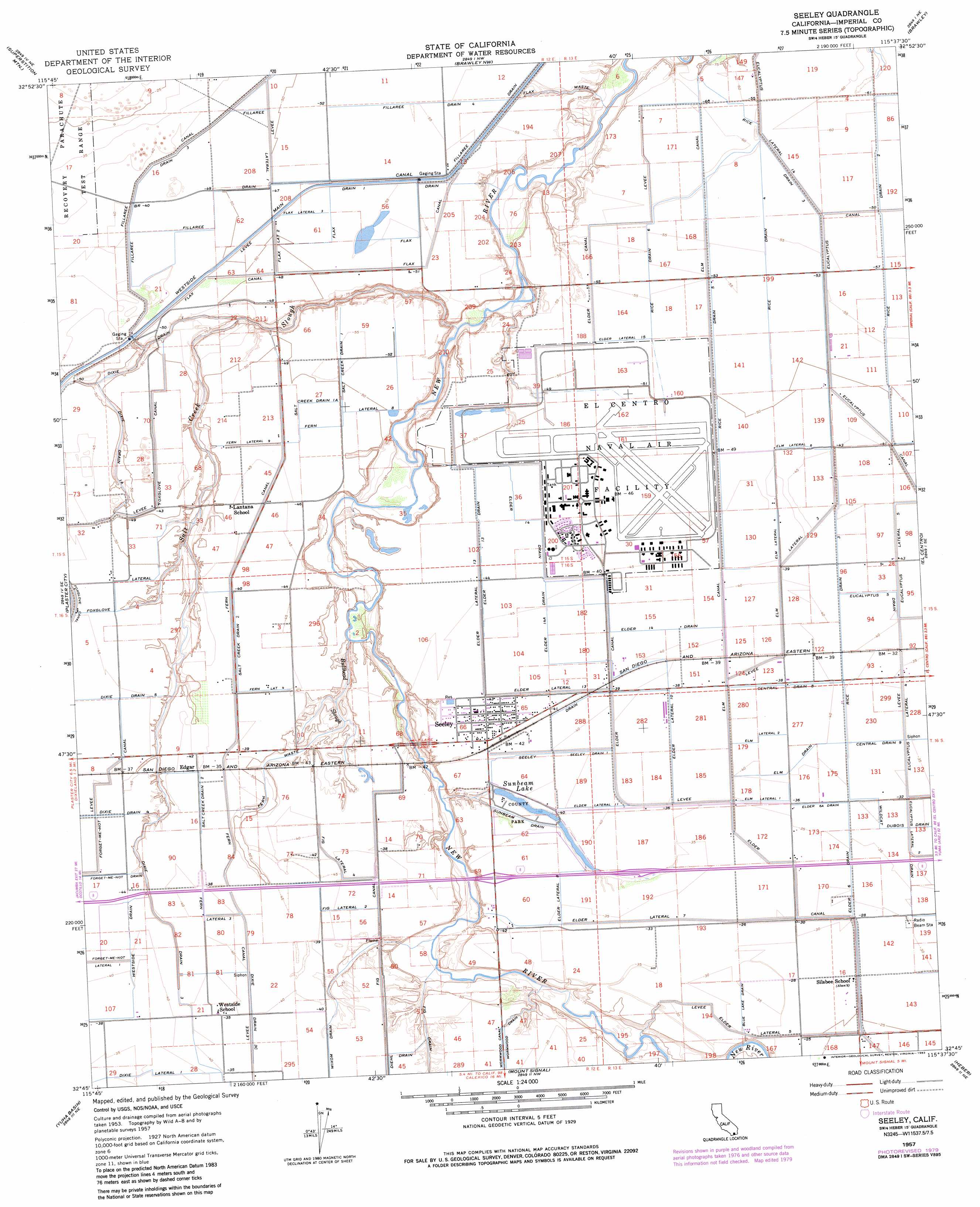
Seeley Topo Map California
To zoom in, hover over the map of Seeley
USGS Topo Quad 32115g6 - 1:24,000 scale
| Topo Map Name: | Seeley |
| USGS Topo Quad ID: | 32115g6 |
| Print Size: | ca. 21 1/4" wide x 27" high |
| Southeast Coordinates: | 32.75° N latitude / 115.625° W longitude |
| Map Center Coordinates: | 32.8125° N latitude / 115.6875° W longitude |
| U.S. State: | CA |
| Filename: | o32115g6.jpg |
| Download Map JPG Image: | Seeley topo map 1:24,000 scale |
| Map Type: | Topographic |
| Topo Series: | 7.5´ |
| Map Scale: | 1:24,000 |
| Source of Map Images: | United States Geological Survey (USGS) |
| Alternate Map Versions: |
Seeley CA 1957, updated 1958 Download PDF Buy paper map Seeley CA 1957, updated 1976 Download PDF Buy paper map Seeley CA 1957, updated 1980 Download PDF Buy paper map Seeley CA 1957, updated 1983 Download PDF Buy paper map Seeley CA 1957, updated 1983 Download PDF Buy paper map Seeley CA 2012 Download PDF Buy paper map Seeley CA 2015 Download PDF Buy paper map |
1:24,000 Topo Quads surrounding Seeley
Harpers Well |
Kane Spring |
Westmorland West |
Westmorland East |
Wiest |
Plaster City Nw |
Superstition Mountain |
Brawley Nw |
Brawley |
Alamorio |
Painted Gorge |
Plaster City |
Seeley |
El Centro |
Holtville West |
Coyote Wells |
Yuha Basin |
Mount Signal |
Heber |
Calexico |
> Back to 32115e1 at 1:100,000 scale
> Back to 32114a1 at 1:250,000 scale
> Back to U.S. Topo Maps home
Seeley topo map: Gazetteer
Seeley: Canals
Blue Lake Drain elevation -9m -30′Central Drain Eight elevation -11m -37′
Central Drain Nine elevation -10m -33′
Diehl Drain elevation -12m -40′
Dixie Drain One elevation -25m -83′
Dixie Drain One-A elevation -17m -56′
Dixie Drain Three elevation -13m -43′
Dixie Lateral One elevation -10m -33′
Elder Canal elevation -17m -56′
Elder Canal elevation -8m -27′
Elder Fourteen Drain elevation -13m -43′
Elder Fourteen-A Drain elevation -12m -40′
Elder Lateral Eight elevation -10m -33′
Elder Lateral Fifteen elevation -15m -50′
Elder Lateral Five elevation -9m -30′
Elder Lateral One elevation -11m -37′
Elder Lateral Seven elevation -9m -30′
Elder Lateral Ten elevation -11m -37′
Elder Lateral Thirteen elevation -11m -37′
Elder Six Drain elevation -9m -30′
Elder Six-A Drain elevation -10m -33′
Elder Thirteen Drain elevation -13m -43′
Elm Canal elevation -11m -37′
Elm Drain elevation -11m -37′
Elm Lateral Four elevation -11m -37′
Elm Lateral One elevation -10m -33′
Elm Lateral Six elevation -13m -43′
Elm Lateral Three elevation -12m -40′
Elm Lateral Two elevation -10m -33′
Eucalyptus Five Drain elevation -11m -37′
Eucalyptus Lateral Fourteen elevation -17m -56′
Fern Canal elevation -11m -37′
Fern Lateral Eight elevation -15m -50′
Fern Lateral Four elevation -11m -37′
Fern Lateral Nine elevation -13m -43′
Fern Lateral Three elevation -11m -37′
Fig Canal elevation -11m -37′
Fig Lateral elevation -11m -37′
Fig Lateral Four elevation -12m -40′
Fillaree Drain elevation -16m -53′
Fillaree Drain Four elevation -16m -53′
Fillaree Drain Three elevation -11m -37′
Fillaree Lateral One elevation -14m -46′
Flax Canal elevation -14m -46′
Flax Drain elevation -16m -53′
Flax Drain One elevation -15m -50′
Flax Lateral Three elevation -14m -46′
Flax Lateral Two elevation -14m -46′
Flax Waste elevation -17m -56′
Forget-Me-Not Canal elevation -12m -40′
Forget-Me-Not Lateral One elevation -11m -37′
Forget-Me-Not Lateral Two elevation -12m -40′
Foxglove Canal elevation -13m -43′
Foxglove Lateral Seven elevation -14m -46′
Rice Drain Five elevation -14m -46′
Rice Drain Four elevation -15m -50′
Rice Drain Six elevation -16m -53′
Rice Drain Three elevation -17m -56′
Rice Drain Two elevation -16m -53′
Salt Creek Drain One elevation -16m -53′
Salt Creek Drain One A elevation -13m -43′
Salt Creek Drain Two elevation -13m -43′
Seeley Drain elevation -11m -37′
Seeley Drain One elevation -11m -37′
Sunbeam Drain elevation -13m -43′
Westside Drain elevation -12m -40′
Wixom Drain elevation -12m -40′
Seeley: Lakes
Sunbeam Lake elevation -13m -43′Seeley: Parks
Sunbeam Lake County Park elevation -12m -40′Sunbeam Recreation Area elevation -12m -40′
Seeley: Populated Places
Edgar elevation -12m -40′Seeley elevation -11m -37′
Seeley: Post Offices
Seeley Post Office elevation -11m -37′Seeley: Streams
Bullhead Slough elevation -24m -79′Salt Creek Slough elevation -33m -109′
Seeley digital topo map on disk
Buy this Seeley topo map showing relief, roads, GPS coordinates and other geographical features, as a high-resolution digital map file on DVD: