Brawley Topo Map California
To zoom in, hover over the map of Brawley
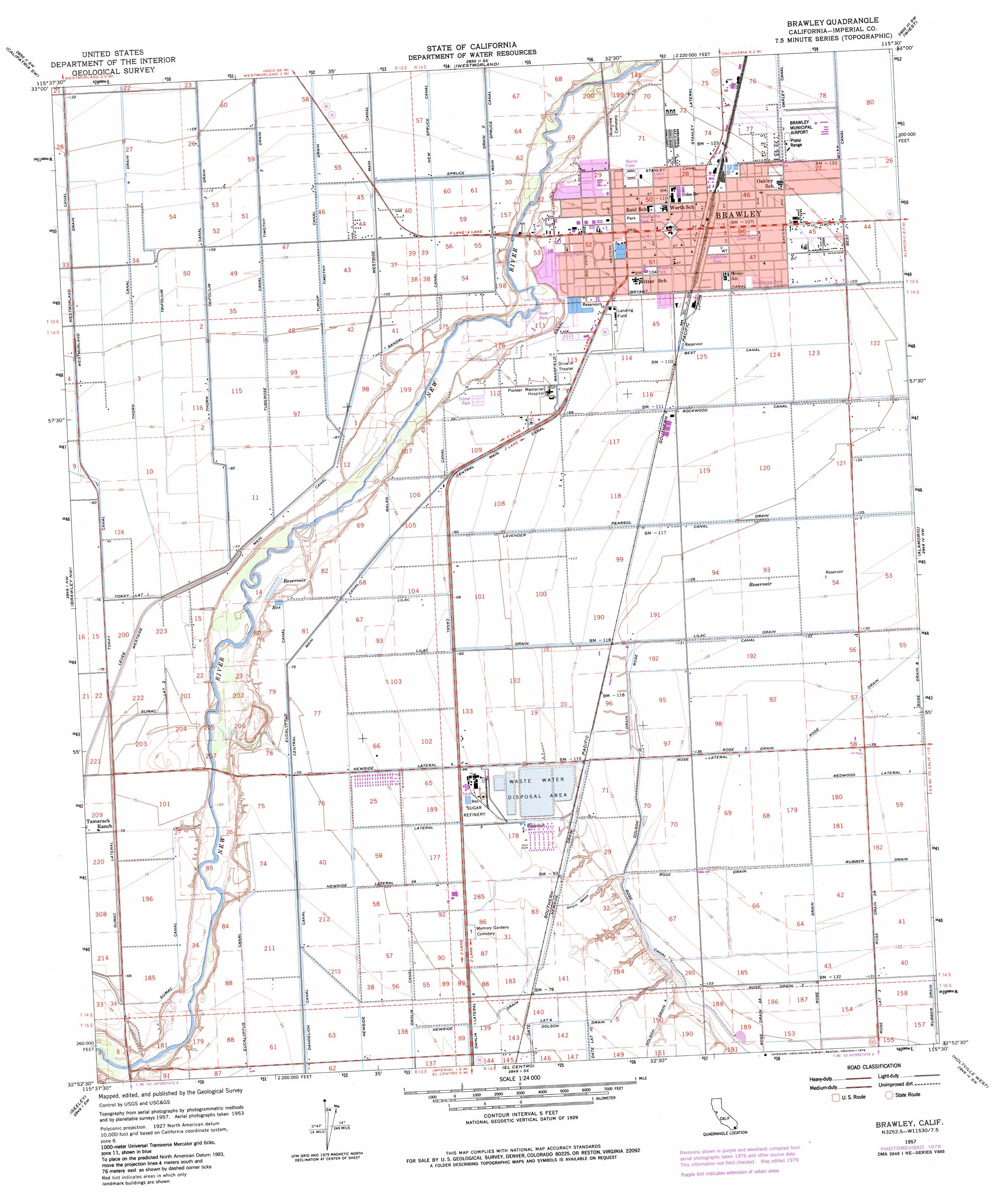
USGS Topo Quad 32115h5 - 1:24,000 scale
| Topo Map Name: | Brawley |
| USGS Topo Quad ID: | 32115h5 |
| Print Size: | ca. 21 1/4" wide x 27" high |
| Southeast Coordinates: | 32.875° N latitude / 115.5° W longitude |
| Map Center Coordinates: | 32.9375° N latitude / 115.5625° W longitude |
| U.S. State: | CA |
| Filename: | o32115h5.jpg |
| Download Map JPG Image: | Brawley topo map 1:24,000 scale |
| Map Type: | Topographic |
| Topo Series: | 7.5´ |
| Map Scale: | 1:24,000 |
| Source of Map Images: | United States Geological Survey (USGS) |
| Alternate Map Versions: |
Brawley CA 1957, updated 1958 Download PDF Buy paper map Brawley CA 1957, updated 1976 Download PDF Buy paper map Brawley CA 1957, updated 1979 Download PDF Buy paper map Brawley CA 1957, updated 1979 Download PDF Buy paper map Brawley CA 1976, updated 1980 Download PDF Buy paper map Brawley CA 2012 Download PDF Buy paper map Brawley CA 2015 Download PDF Buy paper map |
1:24,000 Topo Quads surrounding Brawley
Kane Spring Ne |
Obsidian Butte |
Niland |
Iris |
Tortuga |
Kane Spring |
Westmorland West |
Westmorland East |
Wiest |
Amos |
Superstition Mountain |
Brawley Nw |
Brawley |
Alamorio |
Holtville Ne |
Plaster City |
Seeley |
El Centro |
Holtville West |
Holtville East |
Yuha Basin |
Mount Signal |
Heber |
Calexico |
Bonds Corner |
> Back to 32115e1 at 1:100,000 scale
> Back to 32114a1 at 1:250,000 scale
> Back to U.S. Topo Maps home
Brawley topo map: Gazetteer
Brawley: Airports
Brawley Municipal Airport elevation -40m -132′O'Connell Brothers Airport elevation -32m -105′
Pioneers Memorial Hospital Heliport elevation -30m -99′
Brawley: Canals
Dahlia Canal elevation -20m -66′Dolson Drain elevation -37m -122′
Dolson Drain One elevation -23m -76′
Lateral Three elevation -24m -79′
Lavender Canal elevation -34m -112′
Lilac Canal elevation -26m -86′
Lilac Drain elevation -40m -132′
Malan Canal elevation -26m -86′
Mansfield Canal elevation -30m -99′
Newside Lateral Four elevation -24m -79′
Newside Lateral Three-A elevation -21m -69′
Pearsol Drain elevation -36m -119′
Redwood Lateral Seven elevation -41m -135′
Rose Drain elevation -41m -135′
Rose Drain Eight elevation -40m -132′
Rose Drain One elevation -41m -135′
Rose Drain Three A elevation -41m -135′
Rose Drain Two elevation -39m -128′
Rose Lateral Seven elevation -41m -135′
Rose Seven Drain elevation -41m -135′
Rubber Drain elevation -40m -132′
Rubber Drain One elevation -40m -132′
Sandal Canal elevation -29m -96′
Spruce Drain 2 elevation -34m -112′
Stanley Canal elevation -34m -112′
Stanley Lateral One elevation -37m -122′
Sumac Canal elevation -20m -66′
Sumac Lateral elevation -20m -66′
Sumac Lateral Two elevation -22m -73′
Thorn 1 Canal elevation -29m -96′
Thorn Canal elevation -31m -102′
Timothy One Drain elevation -32m -105′
Timothy Two Drain elevation -32m -105′
Tokay Lateral One elevation -23m -76′
Trifolium Three Drain elevation -33m -109′
Tuberose Canal elevation -29m -96′
Turnip Canal elevation -31m -102′
Westmorland Canal elevation -32m -105′
Westmorland Drain elevation -32m -105′
Westside Main Canal elevation -23m -76′
Brawley: Parks
Alyce Gereaux Park elevation -37m -122′Cline Park elevation -35m -115′
Crestview Park elevation -51m -168′
Guadalupe Park elevation -34m -112′
Hawthorne Park elevation -33m -109′
Lions Field elevation -35m -115′
Longfellow Park elevation -34m -112′
Meserve Park elevation -32m -105′
Pat Williams Park elevation -48m -158′
Plaza Park elevation -33m -109′
Ridge Park elevation -35m -115′
River Park elevation -46m -151′
Warne Field elevation -34m -112′
Warne Park elevation -34m -112′
Weinburg Park elevation -31m -102′
Whittier Park elevation -34m -112′
Brawley: Populated Places
Brawley elevation -34m -112′Citrus View elevation -47m -155′
Brawley: Post Offices
Brawley Post Office elevation -34m -112′Brawley digital topo map on disk
Buy this Brawley topo map showing relief, roads, GPS coordinates and other geographical features, as a high-resolution digital map file on DVD: