Otay Mesa Topo Map California
To zoom in, hover over the map of Otay Mesa
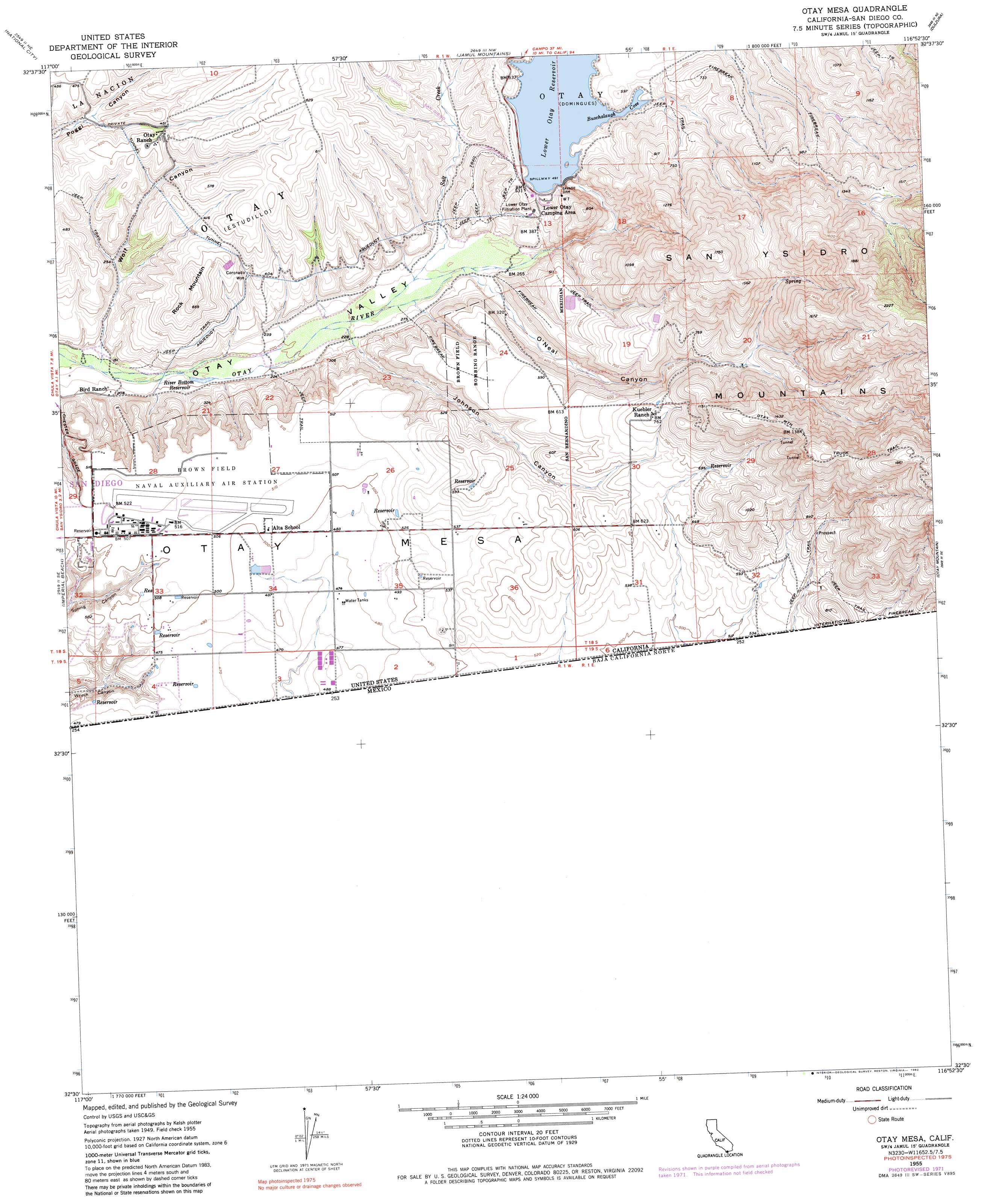
USGS Topo Quad 32116e8 - 1:24,000 scale
| Topo Map Name: | Otay Mesa |
| USGS Topo Quad ID: | 32116e8 |
| Print Size: | ca. 21 1/4" wide x 27" high |
| Southeast Coordinates: | 32.5° N latitude / 116.875° W longitude |
| Map Center Coordinates: | 32.5625° N latitude / 116.9375° W longitude |
| U.S. State: | CA |
| Filename: | o32116e8.jpg |
| Download Map JPG Image: | Otay Mesa topo map 1:24,000 scale |
| Map Type: | Topographic |
| Topo Series: | 7.5´ |
| Map Scale: | 1:24,000 |
| Source of Map Images: | United States Geological Survey (USGS) |
| Alternate Map Versions: |
Otay Mesa CA 1955, updated 1957 Download PDF Buy paper map Otay Mesa CA 1955, updated 1961 Download PDF Buy paper map Otay Mesa CA 1955, updated 1973 Download PDF Buy paper map Otay Mesa CA 1955, updated 1982 Download PDF Buy paper map Otay Mesa CA 1996, updated 2002 Download PDF Buy paper map Otay Mesa CA 2012 Download PDF Buy paper map Otay Mesa CA 2015 Download PDF Buy paper map |
1:24,000 Topo Quads surrounding Otay Mesa
La Jolla |
La Mesa |
El Cajon |
Alpine |
Viejas Mountain |
Point Loma |
National City |
Jamul Mountains |
Dulzura |
Barrett Lake |
Imperial Beach |
Otay Mesa |
Otay Mountain |
Tecate |
|
> Back to 32116e1 at 1:100,000 scale
> Back to 32116a1 at 1:250,000 scale
> Back to U.S. Topo Maps home
Otay Mesa topo map: Gazetteer
Otay Mesa: Airports
Brown Field Municipal Airport elevation 158m 518′Otay Mesa: Bays
Buschalaugh Cove elevation 150m 492′Otay Mesa: Dams
Coronado Wye elevation 124m 406′Savage Dam elevation 164m 538′
Otay Mesa: Parks
Otay County Open Space Preserve elevation 243m 797′Otay Lake County Park elevation 145m 475′
Otay Mesa: Reservoirs
Lower Otay Lake elevation 116m 380′River Botton Reservoir elevation 57m 187′
Otay Mesa: Streams
Salt Creek elevation 73m 239′Otay Mesa: Summits
Otay Mesa elevation 189m 620′Rock Mountain elevation 201m 659′
Otay Mesa: Valleys
Johnson Canyon elevation 70m 229′O'Neal Canyon elevation 79m 259′
Wolf Canyon elevation 50m 164′
Otay Mesa digital topo map on disk
Buy this Otay Mesa topo map showing relief, roads, GPS coordinates and other geographical features, as a high-resolution digital map file on DVD: