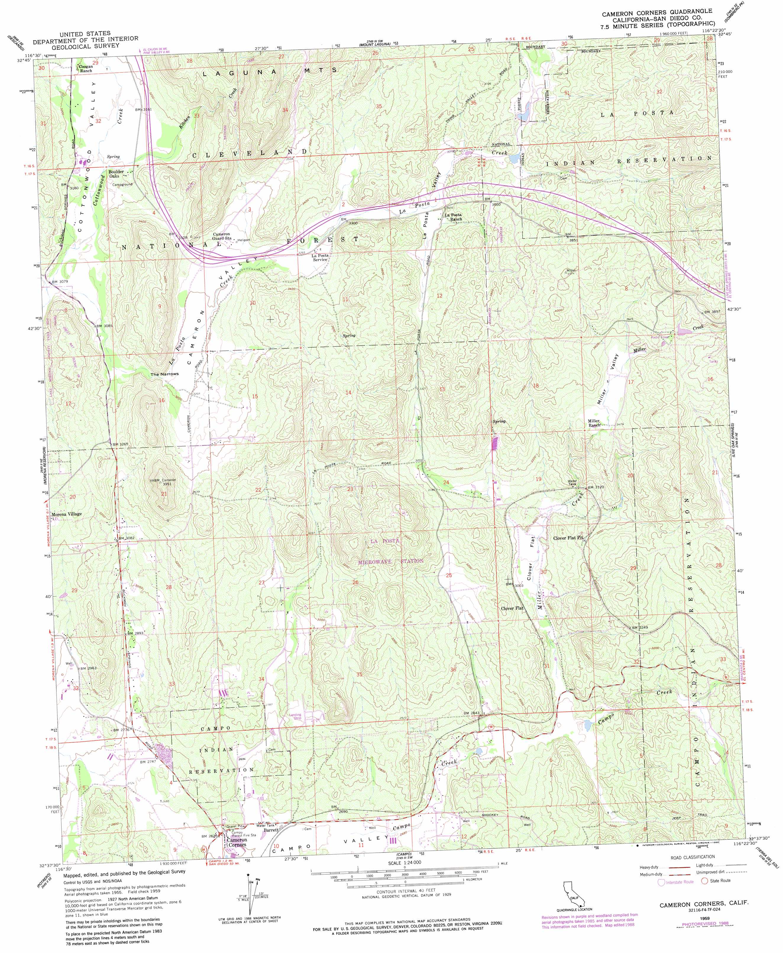
Cameron Corners Topo Map California
To zoom in, hover over the map of Cameron Corners
USGS Topo Quad 32116f4 - 1:24,000 scale
| Topo Map Name: | Cameron Corners |
| USGS Topo Quad ID: | 32116f4 |
| Print Size: | ca. 21 1/4" wide x 27" high |
| Southeast Coordinates: | 32.625° N latitude / 116.375° W longitude |
| Map Center Coordinates: | 32.6875° N latitude / 116.4375° W longitude |
| U.S. State: | CA |
| Filename: | o32116f4.jpg |
| Download Map JPG Image: | Cameron Corners topo map 1:24,000 scale |
| Map Type: | Topographic |
| Topo Series: | 7.5´ |
| Map Scale: | 1:24,000 |
| Source of Map Images: | United States Geological Survey (USGS) |
| Alternate Map Versions: |
Cameron Corners CA 1959, updated 1961 Download PDF Buy paper map Cameron Corners CA 1959, updated 1961 Download PDF Buy paper map Cameron Corners CA 1959, updated 1964 Download PDF Buy paper map Cameron Corners CA 1959, updated 1978 Download PDF Buy paper map Cameron Corners CA 1959, updated 1978 Download PDF Buy paper map Cameron Corners CA 1959, updated 1985 Download PDF Buy paper map Cameron Corners CA 1959, updated 1988 Download PDF Buy paper map Cameron Corners CA 1997, updated 2000 Download PDF Buy paper map Cameron Corners CA 2012 Download PDF Buy paper map Cameron Corners CA 2015 Download PDF Buy paper map |
| FStopo: | US Forest Service topo Cameron Corners is available: Download FStopo PDF Download FStopo TIF |
1:24,000 Topo Quads surrounding Cameron Corners
Tule Springs |
Cuyamaca Peak |
Monument Peak |
Agua Caliente Springs |
Arroyo Tapiado |
Viejas Mountain |
Descanso |
Mount Laguna |
Sombrero Peak |
Sweeney Pass |
Barrett Lake |
Morena Reservoir |
Cameron Corners |
Live Oak Springs |
Jacumba |
Tecate |
Potrero |
Campo |
Tierra Del Sol |
|
> Back to 32116e1 at 1:100,000 scale
> Back to 32116a1 at 1:250,000 scale
> Back to U.S. Topo Maps home
Cameron Corners topo map: Gazetteer
Cameron Corners: Flats
Clover Flat elevation 907m 2975′Cameron Corners: Gaps
The Narrows elevation 962m 3156′Cameron Corners: Populated Places
Barrett elevation 804m 2637′Boulder Oaks elevation 961m 3152′
Cameron Corners elevation 802m 2631′
Clover Flat elevation 911m 2988′
Cameron Corners: Streams
Kitchen Creek elevation 947m 3106′La Posta Creek elevation 934m 3064′
Miller Creek elevation 873m 2864′
Cameron Corners: Valleys
Cameron Valley elevation 971m 3185′La Posta Valley elevation 1038m 3405′
Miller Valley elevation 975m 3198′
Smith Canyon elevation 826m 2709′
Cameron Corners digital topo map on disk
Buy this Cameron Corners topo map showing relief, roads, GPS coordinates and other geographical features, as a high-resolution digital map file on DVD: