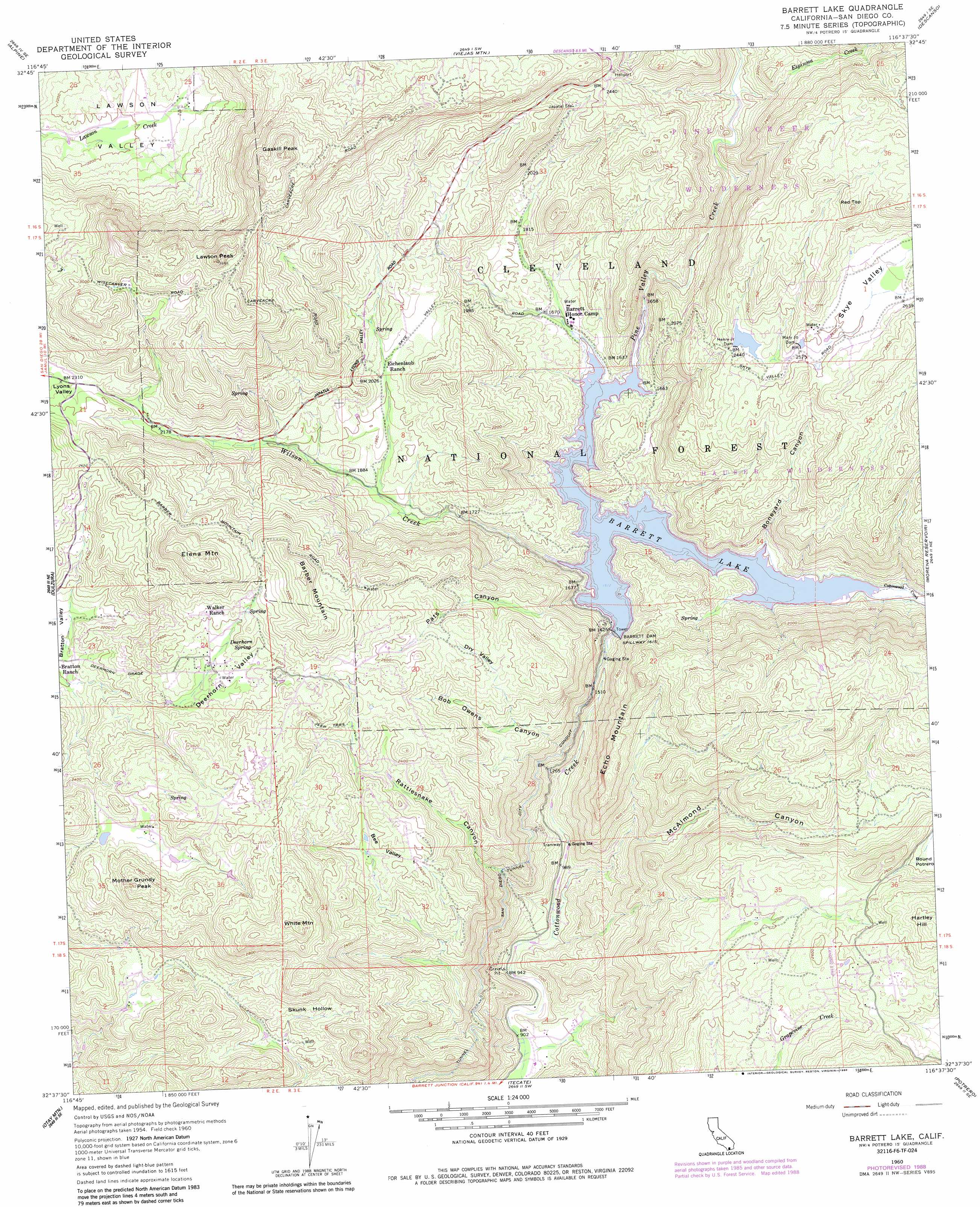
Barrett Lake Topo Map California
To zoom in, hover over the map of Barrett Lake
USGS Topo Quad 32116f6 - 1:24,000 scale
| Topo Map Name: | Barrett Lake |
| USGS Topo Quad ID: | 32116f6 |
| Print Size: | ca. 21 1/4" wide x 27" high |
| Southeast Coordinates: | 32.625° N latitude / 116.625° W longitude |
| Map Center Coordinates: | 32.6875° N latitude / 116.6875° W longitude |
| U.S. State: | CA |
| Filename: | o32116f6.jpg |
| Download Map JPG Image: | Barrett Lake topo map 1:24,000 scale |
| Map Type: | Topographic |
| Topo Series: | 7.5´ |
| Map Scale: | 1:24,000 |
| Source of Map Images: | United States Geological Survey (USGS) |
| Alternate Map Versions: |
Barrett Lake CA 1960, updated 1961 Download PDF Buy paper map Barrett Lake CA 1960, updated 1968 Download PDF Buy paper map Barrett Lake CA 1960, updated 1968 Download PDF Buy paper map Barrett Lake CA 1960, updated 1984 Download PDF Buy paper map Barrett Lake CA 1960, updated 1988 Download PDF Buy paper map Barrett Lake CA 1997, updated 2000 Download PDF Buy paper map Barrett Lake CA 2012 Download PDF Buy paper map Barrett Lake CA 2015 Download PDF Buy paper map |
| FStopo: | US Forest Service topo Barrett Lake is available: Download FStopo PDF Download FStopo TIF |
1:24,000 Topo Quads surrounding Barrett Lake
San Vicente Reservoir |
El Cajon Mountain |
Tule Springs |
Cuyamaca Peak |
Monument Peak |
El Cajon |
Alpine |
Viejas Mountain |
Descanso |
Mount Laguna |
Jamul Mountains |
Dulzura |
Barrett Lake |
Morena Reservoir |
Cameron Corners |
Otay Mesa |
Otay Mountain |
Tecate |
Potrero |
Campo |
> Back to 32116e1 at 1:100,000 scale
> Back to 32116a1 at 1:250,000 scale
> Back to U.S. Topo Maps home
Barrett Lake topo map: Gazetteer
Barrett Lake: Airports
Reider Ranch Airport elevation 790m 2591′Barrett Lake: Canals
San Diego City Conduit elevation 459m 1505′Barrett Lake: Dams
Barrett Dam elevation 467m 1532′Barrett Dam elevation 481m 1578′
Henry Jr 841 Dam elevation 750m 2460′
Henry Junior Dam elevation 751m 2463′
Mary Jo 841-002 Dam elevation 785m 2575′
Mary Jo Dam elevation 785m 2575′
Barrett Lake: Reservoirs
Barrett Lake elevation 487m 1597′Barrett Lake: Springs
Deerhorn Spring elevation 770m 2526′Barrett Lake: Streams
Espinosa Creek elevation 587m 1925′Pine Valley Creek elevation 487m 1597′
Wilson Creek elevation 487m 1597′
Barrett Lake: Summits
Barber Mountain elevation 985m 3231′Echo Mountain elevation 764m 2506′
Elena Mountain elevation 1015m 3330′
Gaskill Peak elevation 1157m 3795′
Lawson Peak elevation 1099m 3605′
Mother Grundy Peak elevation 927m 3041′
Red Top elevation 986m 3234′
White Mountain elevation 989m 3244′
Barrett Lake: Valleys
Bee Valley elevation 706m 2316′Bob Owens Canyon elevation 353m 1158′
Boneyard Canyon elevation 491m 1610′
Corral Canyon elevation 803m 2634′
Deerhorn Valley elevation 612m 2007′
Dry Valley elevation 614m 2014′
Hauser Canyon elevation 486m 1594′
McAlmond Canyon elevation 300m 984′
Pats Canyon elevation 487m 1597′
Rattlesnake Canyon elevation 297m 974′
Skunk Hollow elevation 646m 2119′
Barrett Lake digital topo map on disk
Buy this Barrett Lake topo map showing relief, roads, GPS coordinates and other geographical features, as a high-resolution digital map file on DVD: