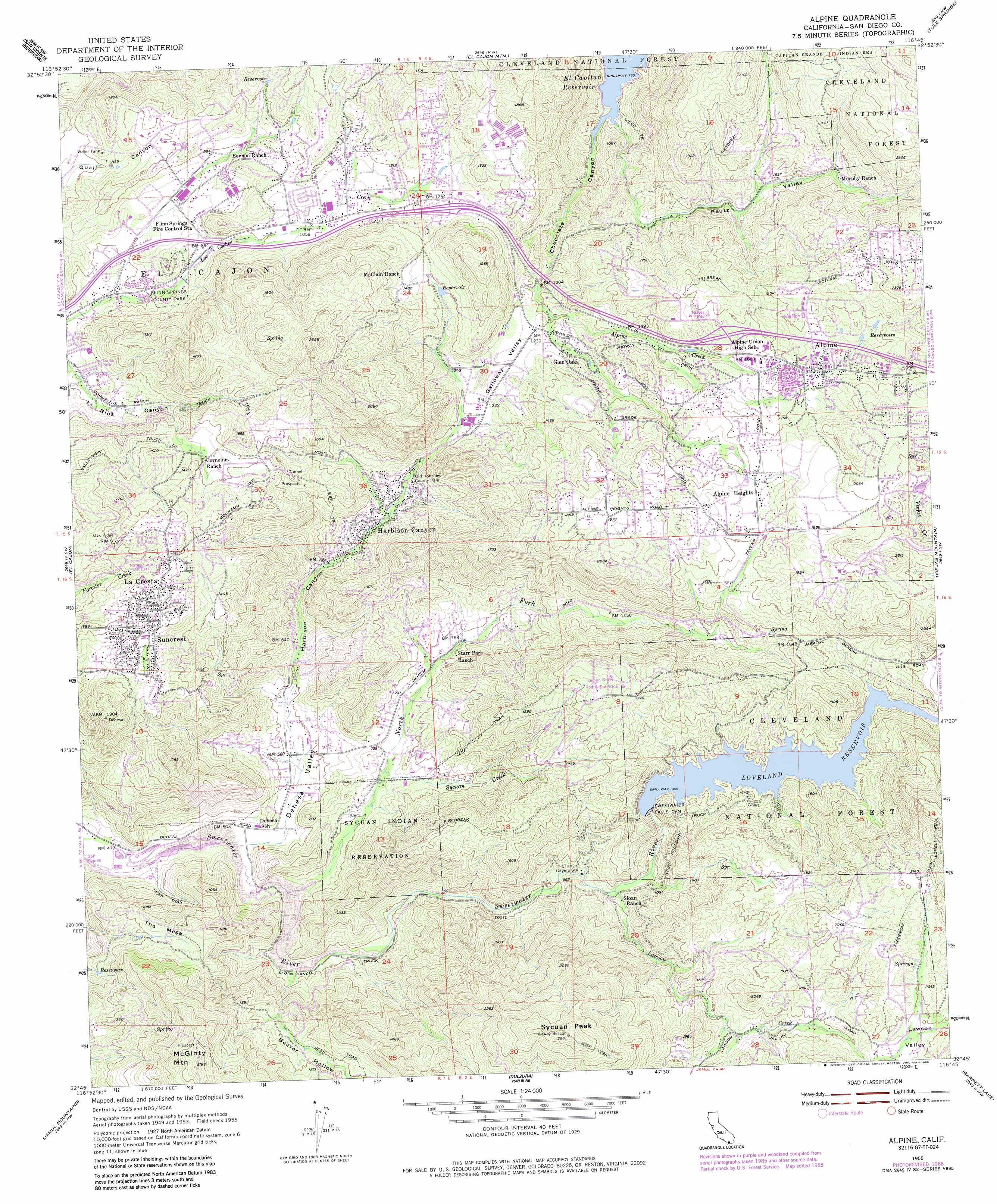
Alpine Topo Map California
To zoom in, hover over the map of Alpine
USGS Topo Quad 32116g7 - 1:24,000 scale
| Topo Map Name: | Alpine |
| USGS Topo Quad ID: | 32116g7 |
| Print Size: | ca. 21 1/4" wide x 27" high |
| Southeast Coordinates: | 32.75° N latitude / 116.75° W longitude |
| Map Center Coordinates: | 32.8125° N latitude / 116.8125° W longitude |
| U.S. State: | CA |
| Filename: | o32116g7.jpg |
| Download Map JPG Image: | Alpine topo map 1:24,000 scale |
| Map Type: | Topographic |
| Topo Series: | 7.5´ |
| Map Scale: | 1:24,000 |
| Source of Map Images: | United States Geological Survey (USGS) |
| Alternate Map Versions: |
Alpine CA 1955, updated 1957 Download PDF Buy paper map Alpine CA 1955, updated 1960 Download PDF Buy paper map Alpine CA 1955, updated 1973 Download PDF Buy paper map Alpine CA 1955, updated 1984 Download PDF Buy paper map Alpine CA 1955, updated 1988 Download PDF Buy paper map Alpine CA 1997, updated 2000 Download PDF Buy paper map Alpine CA 2012 Download PDF Buy paper map Alpine CA 2015 Download PDF Buy paper map |
| FStopo: | US Forest Service topo Alpine is available: Download FStopo PDF Download FStopo TIF |
1:24,000 Topo Quads surrounding Alpine
Escondido |
San Pasqual |
Ramona |
Santa Ysabel |
Julian |
Poway |
San Vicente Reservoir |
El Cajon Mountain |
Tule Springs |
Cuyamaca Peak |
La Mesa |
El Cajon |
Alpine |
Viejas Mountain |
Descanso |
National City |
Jamul Mountains |
Dulzura |
Barrett Lake |
Morena Reservoir |
Imperial Beach |
Otay Mesa |
Otay Mountain |
Tecate |
Potrero |
> Back to 32116e1 at 1:100,000 scale
> Back to 32116a1 at 1:250,000 scale
> Back to U.S. Topo Maps home
Alpine topo map: Gazetteer
Alpine: Crossings
Interchange 27 elevation 389m 1276′Interchange 30 elevation 523m 1715′
Alpine: Dams
Blossom Valley Reservoir 1060 Dam elevation 291m 954′Lake Loveland 2020-002 Dam elevation 413m 1354′
Sweetwater Falls Dam elevation 409m 1341′
Alpine: Mines
Oak Ridge Quarry elevation 500m 1640′Red Rose Quarry elevation 472m 1548′
Alpine: Parks
Flinn Springs County Park elevation 254m 833′Nancy Jane County Park elevation 452m 1482′
Old Ironsides County Park elevation 292m 958′
South Lane Park elevation 474m 1555′
Alpine: Populated Places
Alpine elevation 559m 1833′Alpine Heights elevation 570m 1870′
Blossom Valley elevation 306m 1003′
Crest elevation 500m 1640′
Dehesa elevation 156m 511′
Flinn Springs elevation 324m 1062′
Glen Oaks elevation 389m 1276′
Harbison Canyon elevation 276m 905′
La Cresta elevation 502m 1646′
Suncrest elevation 478m 1568′
Alpine: Post Offices
Alpine Post Office elevation 560m 1837′Alpine: Reservoirs
Loveland Reservoir elevation 368m 1207′Alpine: Streams
Alpine Creek elevation 352m 1154′Lawson Creek elevation 283m 928′
North Fork Sweetwater River elevation 158m 518′
Sycuan Creek elevation 205m 672′
Viejas Creek elevation 536m 1758′
Alpine: Summits
McGinty Mountain elevation 652m 2139′Sycuan Peak elevation 840m 2755′
The Mesa elevation 392m 1286′
Alpine: Trails
Anderson Truck Trail elevation 405m 1328′Cornelius Ranch Truck Trail elevation 420m 1377′
West Boundary Truck Trail elevation 629m 2063′
Alpine: Valleys
Beaver Hollow elevation 171m 561′Chocolate Canyon elevation 254m 833′
Dehesa Valley elevation 153m 501′
Galloway Valley elevation 358m 1174′
Harbison Canyon elevation 172m 564′
Peutz Valley elevation 245m 803′
Alpine digital topo map on disk
Buy this Alpine topo map showing relief, roads, GPS coordinates and other geographical features, as a high-resolution digital map file on DVD: