Tule Springs Topo Map California
To zoom in, hover over the map of Tule Springs
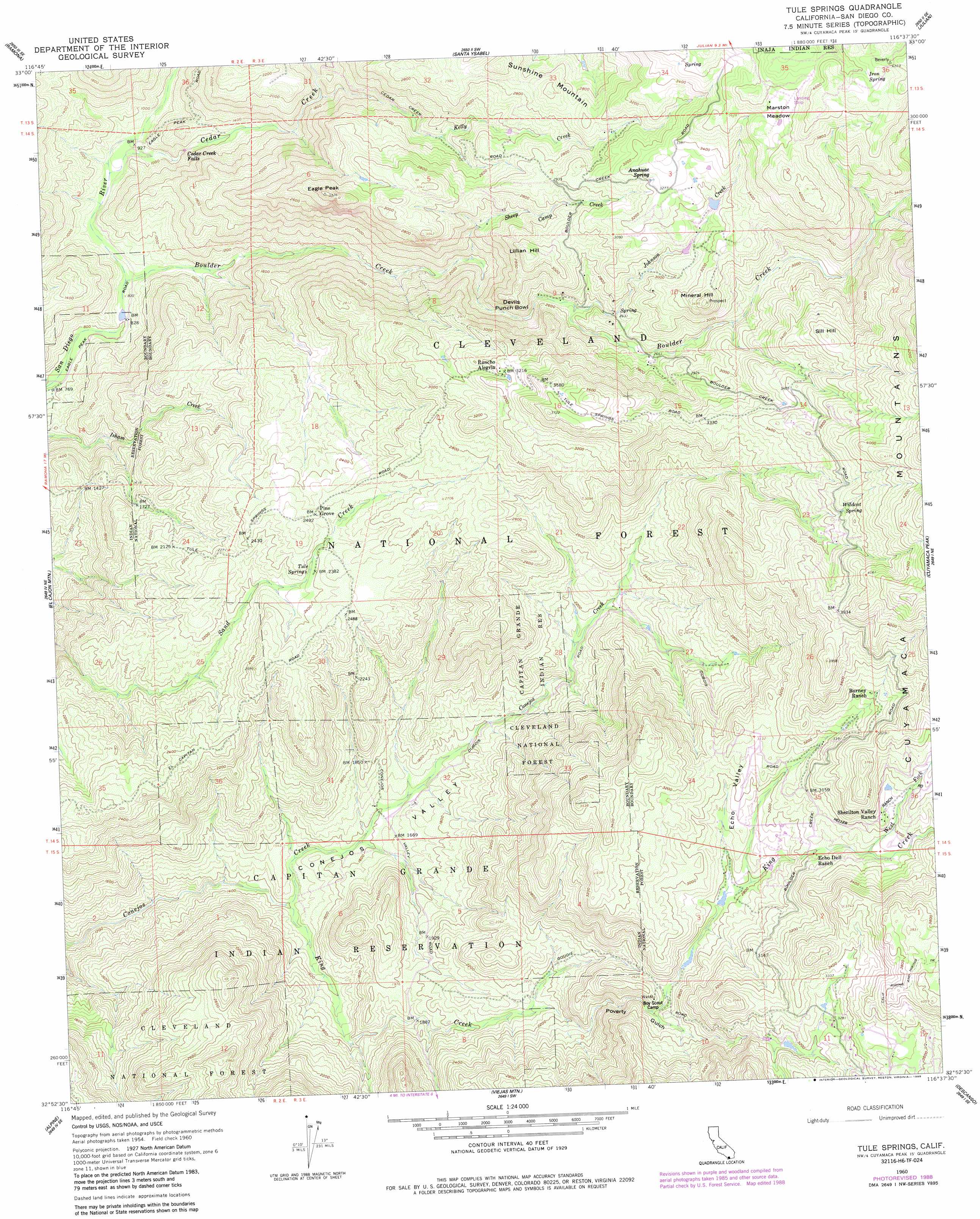
USGS Topo Quad 32116h6 - 1:24,000 scale
| Topo Map Name: | Tule Springs |
| USGS Topo Quad ID: | 32116h6 |
| Print Size: | ca. 21 1/4" wide x 27" high |
| Southeast Coordinates: | 32.875° N latitude / 116.625° W longitude |
| Map Center Coordinates: | 32.9375° N latitude / 116.6875° W longitude |
| U.S. State: | CA |
| Filename: | o32116h6.jpg |
| Download Map JPG Image: | Tule Springs topo map 1:24,000 scale |
| Map Type: | Topographic |
| Topo Series: | 7.5´ |
| Map Scale: | 1:24,000 |
| Source of Map Images: | United States Geological Survey (USGS) |
| Alternate Map Versions: |
Tule Springs CA 1960, updated 1961 Download PDF Buy paper map Tule Springs CA 1960, updated 1966 Download PDF Buy paper map Tule Springs CA 1960, updated 1980 Download PDF Buy paper map Tule Springs CA 1960, updated 1984 Download PDF Buy paper map Tule Springs CA 1960, updated 1989 Download PDF Buy paper map Tule Springs CA 1997, updated 2000 Download PDF Buy paper map Tule Springs CA 2012 Download PDF Buy paper map Tule Springs CA 2015 Download PDF Buy paper map |
| FStopo: | US Forest Service topo Tule Springs is available: Download FStopo PDF Download FStopo TIF |
1:24,000 Topo Quads surrounding Tule Springs
Rodriguez Mountain |
Mesa Grande |
Warners Ranch |
Ranchita |
Tubb Canyon |
San Pasqual |
Ramona |
Santa Ysabel |
Julian |
Earthquake Valley |
San Vicente Reservoir |
El Cajon Mountain |
Tule Springs |
Cuyamaca Peak |
Monument Peak |
El Cajon |
Alpine |
Viejas Mountain |
Descanso |
Mount Laguna |
Jamul Mountains |
Dulzura |
Barrett Lake |
Morena Reservoir |
Cameron Corners |
> Back to 32116e1 at 1:100,000 scale
> Back to 32116a1 at 1:250,000 scale
> Back to U.S. Topo Maps home
Tule Springs topo map: Gazetteer
Tule Springs: Basins
Devils Punchbowl elevation 780m 2559′Tule Springs: Falls
Cedar Creek Falls elevation 304m 997′Tule Springs: Flats
Marston Meadow elevation 1145m 3756′Tule Springs: Mines
Coarse Gold Prospect elevation 704m 2309′Gold Crown Prospect elevation 1022m 3353′
Last Chance Mine elevation 865m 2837′
Mineral Hill Mine elevation 845m 2772′
Nona Prospect elevation 688m 2257′
Penny Mine elevation 898m 2946′
Prosperity Prospect elevation 900m 2952′
Spanish Bayonet Mine elevation 930m 3051′
Tule Springs: Populated Places
Pine Grove elevation 758m 2486′Tule Springs: Springs
Anahuac Spring elevation 997m 3270′Iron Spring elevation 1229m 4032′
Tule Springs elevation 725m 2378′
Wildcat Spring elevation 1114m 3654′
Tule Springs: Streams
Boulder Creek elevation 252m 826′Cedar Creek elevation 266m 872′
Johnson Creek elevation 804m 2637′
Kelly Creek elevation 524m 1719′
King Creek elevation 426m 1397′
Sheep Camp Creek elevation 597m 1958′
West Fork King Creek elevation 939m 3080′
Tule Springs: Summits
Eagle Peak elevation 973m 3192′Lillian Hill elevation 966m 3169′
Mineral Hill elevation 1061m 3480′
Sill Hill elevation 1133m 3717′
Sunshine Mountain elevation 916m 3005′
Tule Springs: Valleys
Conejos Valley elevation 339m 1112′Echo Valley elevation 852m 2795′
Poverty Gulch elevation 647m 2122′
Tule Springs digital topo map on disk
Buy this Tule Springs topo map showing relief, roads, GPS coordinates and other geographical features, as a high-resolution digital map file on DVD: