La Mesa Topo Map California
To zoom in, hover over the map of La Mesa
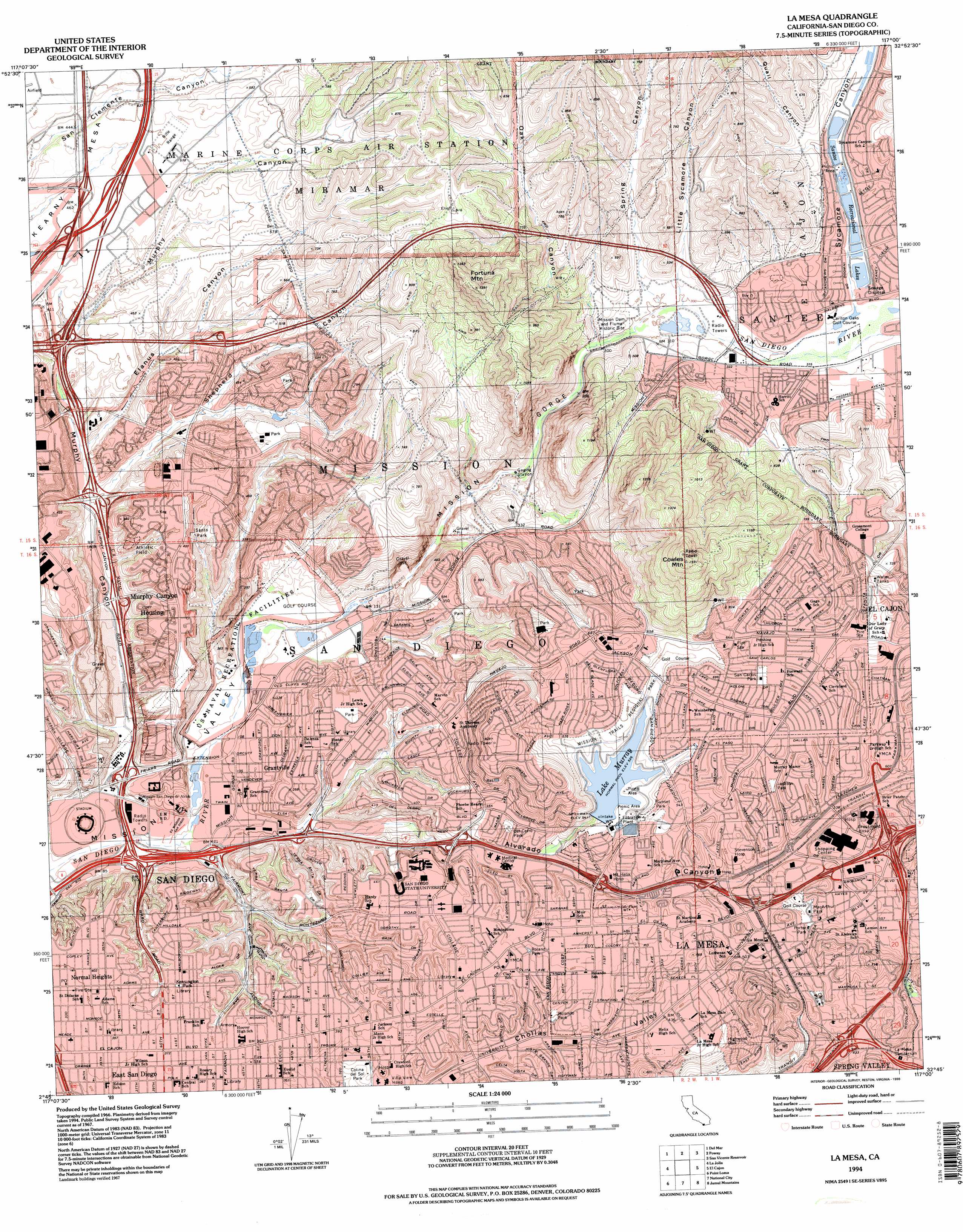
USGS Topo Quad 32117g1 - 1:24,000 scale
| Topo Map Name: | La Mesa |
| USGS Topo Quad ID: | 32117g1 |
| Print Size: | ca. 21 1/4" wide x 27" high |
| Southeast Coordinates: | 32.75° N latitude / 117° W longitude |
| Map Center Coordinates: | 32.8125° N latitude / 117.0625° W longitude |
| U.S. State: | CA |
| Filename: | o32117g1.jpg |
| Download Map JPG Image: | La Mesa topo map 1:24,000 scale |
| Map Type: | Topographic |
| Topo Series: | 7.5´ |
| Map Scale: | 1:24,000 |
| Source of Map Images: | United States Geological Survey (USGS) |
| Alternate Map Versions: |
La Mesa CA 1947 Download PDF Buy paper map La Mesa CA 1953, updated 1955 Download PDF Buy paper map La Mesa CA 1953, updated 1959 Download PDF Buy paper map La Mesa CA 1967, updated 1969 Download PDF Buy paper map La Mesa CA 1967, updated 1975 Download PDF Buy paper map La Mesa CA 1967, updated 1978 Download PDF Buy paper map La Mesa CA 1967, updated 1984 Download PDF Buy paper map La Mesa CA 1994, updated 1998 Download PDF Buy paper map La Mesa CA 2012 Download PDF Buy paper map La Mesa CA 2015 Download PDF Buy paper map |
1:24,000 Topo Quads surrounding La Mesa
Encinitas |
Rancho Santa Fe |
Escondido |
San Pasqual |
Ramona |
Del Mar |
Poway |
San Vicente Reservoir |
El Cajon Mountain |
|
La Jolla |
La Mesa |
El Cajon |
Alpine |
|
Point Loma |
National City |
Jamul Mountains |
Dulzura |
|
Imperial Beach |
Otay Mesa |
Otay Mountain |
> Back to 32117e1 at 1:100,000 scale
> Back to 32116a1 at 1:250,000 scale
> Back to U.S. Topo Maps home
La Mesa topo map: Gazetteer
La Mesa: Airports
Grossmont Hospital Heliport elevation 194m 636′La Mesa: Crossings
Interchange 10 elevation 103m 337′Interchange 11 elevation 122m 400′
Interchange 11 elevation 92m 301′
Interchange 12 elevation 147m 482′
Interchange 12 elevation 136m 446′
Interchange 13A elevation 168m 551′
Interchange 13B elevation 171m 561′
Interchange 14A elevation 188m 616′
Interchange 14B elevation 208m 682′
Interchange 16 elevation 117m 383′
Interchange 5B elevation 114m 374′
Interchange 6A elevation 101m 331′
Interchange 6B elevation 29m 95′
Interchange 7 elevation 30m 98′
Interchange 7 elevation 28m 91′
Interchange 8 elevation 56m 183′
Interchange 9 elevation 62m 203′
Interchange 9 elevation 40m 131′
La Mesa: Dams
Alvarado Regulating 8-013 Dam elevation 160m 524′Earl Thomas Reservoir 8-015 Dam elevation 163m 534′
Murray 8-012 Dam elevation 143m 469′
Old Mission Dam elevation 83m 272′
La Mesa: Parks
Adams Avenue Park elevation 123m 403′Allied Gardens Community Park elevation 103m 337′
Allied Gardens Recreation Center elevation 102m 334′
Aztec Bowl elevation 128m 419′
Aztec Park elevation 161m 528′
Briercrest Park elevation 198m 649′
City Heights Community Park elevation 111m 364′
Clay Park elevation 140m 459′
Colina del Sol Park elevation 108m 354′
Collier Park elevation 153m 501′
Dailard Park elevation 157m 515′
Del Cerro Park elevation 137m 449′
East San Diego Adult Recreation Center elevation 111m 364′
Eucalyptus Park elevation 146m 479′
Grantville Park elevation 39m 127′
Highwood Park elevation 168m 551′
Jackson Park elevation 172m 564′
Kensington Park elevation 114m 374′
La Mesita Park elevation 177m 580′
MacArthur Park elevation 172m 564′
MacArthur Park Recreation Center elevation 175m 574′
Mission Trails Regional Park elevation 194m 636′
Mission Trails Regional Park elevation 176m 577′
Montezuma Park elevation 141m 462′
Northmont Park elevation 183m 600′
Porter Park elevation 170m 557′
Princess del Seno Park elevation 133m 436′
Qualcomm Stadium elevation 25m 82′
Rancho Mission Canyon Park elevation 106m 347′
Renzuilli Park elevation 103m 337′
Roadrunner Park elevation 96m 314′
Rolando Park elevation 123m 403′
San Carlos Park elevation 202m 662′
San Carlos Recreation Center elevation 202m 662′
Scripps Park elevation 128m 419′
Smith Field elevation 134m 439′
Sunset Park elevation 163m 534′
Sunshine Park elevation 137m 449′
Tierrasanta Community Park elevation 154m 505′
Tuxedo Park elevation 197m 646′
West Hills Park elevation 117m 383′
West Renzuilli Park elevation 108m 354′
La Mesa: Populated Places
Allied Gardens elevation 103m 337′College Heights elevation 138m 452′
Del Cerro elevation 131m 429′
Grantville elevation 31m 101′
Greenbrier Mobile Home Park elevation 109m 357′
Highlands Mobile Home Park elevation 130m 426′
La Mesa elevation 161m 528′
Meadowbrook Mobile Home Park elevation 98m 321′
Mission Gorge Villa Mobile Home Park elevation 105m 344′
Normal Heights elevation 121m 396′
Pleasant Valley Mobile Home Park elevation 117m 383′
Tierrasanta elevation 98m 321′
La Mesa: Post Offices
Andrew Jackson Post Office elevation 144m 472′Grantville Post Office elevation 30m 98′
John Adams Post Office elevation 121m 396′
La Mesa Annex Post Office elevation 189m 620′
La Mesa Post Office elevation 163m 534′
Navajo Post Office elevation 208m 682′
Tierrasanta Post Office elevation 141m 462′
La Mesa: Reservoirs
Del Cerro Reservoir elevation 201m 659′Hollis Lake elevation 89m 291′
Murray Reservoir elevation 143m 469′
Santee Recreational Lakes elevation 101m 331′
La Mesa: Streams
Forester Creek elevation 89m 291′La Mesa: Summits
Cowles Mountain elevation 465m 1525′Fortuna Mountain elevation 379m 1243′
La Mesa: Valleys
Alvarado Canyon elevation 31m 101′Elanus Canyon elevation 70m 229′
Little Sycamore Canyon elevation 99m 324′
Mission Gorge elevation 61m 200′
Murphy Canyon elevation 22m 72′
Oak Canyon elevation 85m 278′
Quail Canyon elevation 118m 387′
Shepherd Canyon elevation 62m 203′
Spring Canyon elevation 96m 314′
Sycamore Canyon elevation 96m 314′
La Mesa digital topo map on disk
Buy this La Mesa topo map showing relief, roads, GPS coordinates and other geographical features, as a high-resolution digital map file on DVD: