Kure Beach Topo Map North Carolina
To zoom in, hover over the map of Kure Beach
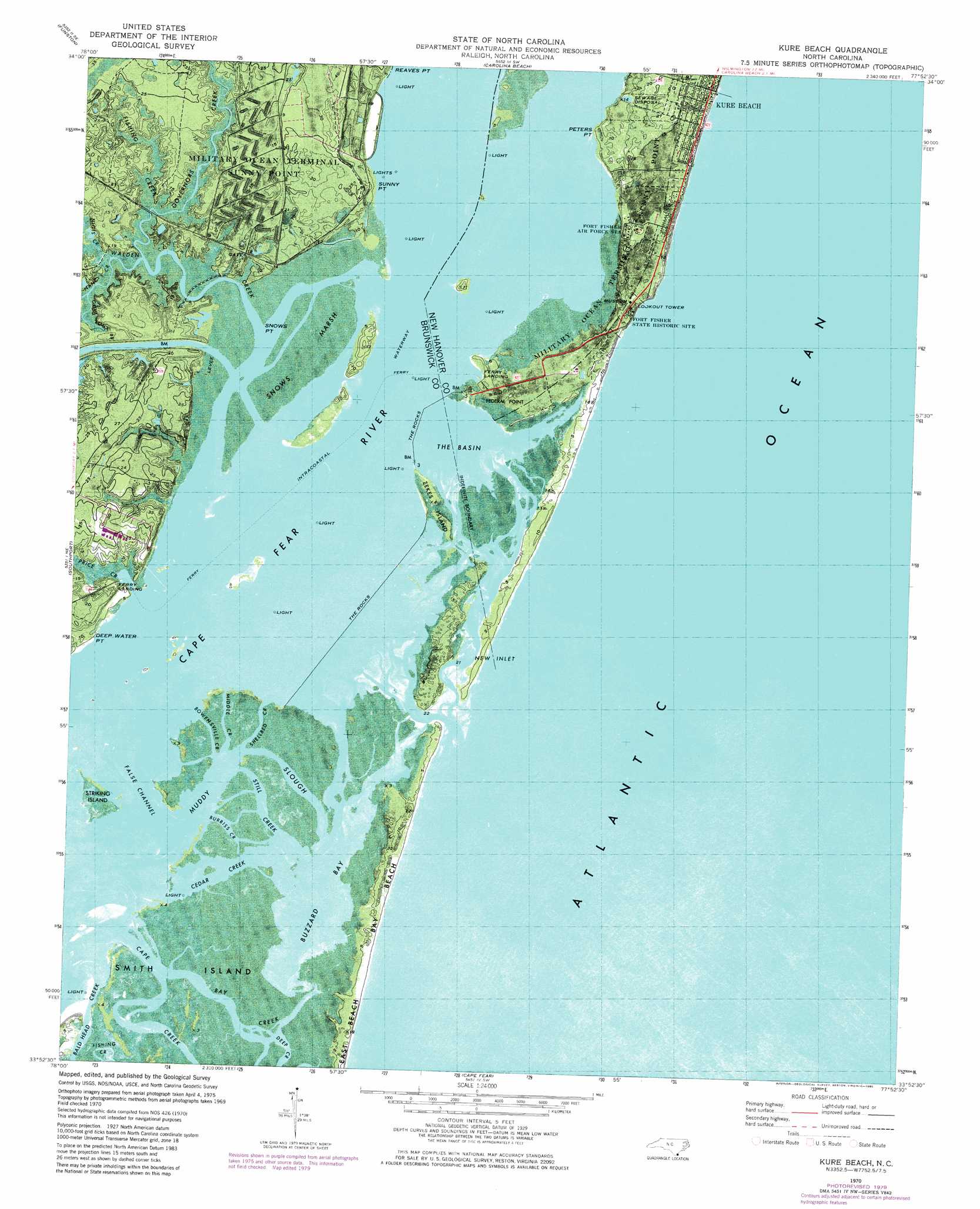
USGS Topo Quad 33077h8 - 1:24,000 scale
| Topo Map Name: | Kure Beach |
| USGS Topo Quad ID: | 33077h8 |
| Print Size: | ca. 21 1/4" wide x 27" high |
| Southeast Coordinates: | 33.875° N latitude / 77.875° W longitude |
| Map Center Coordinates: | 33.9375° N latitude / 77.9375° W longitude |
| U.S. State: | NC |
| Filename: | o33077h8.jpg |
| Download Map JPG Image: | Kure Beach topo map 1:24,000 scale |
| Map Type: | Topographic |
| Topo Series: | 7.5´ |
| Map Scale: | 1:24,000 |
| Source of Map Images: | United States Geological Survey (USGS) |
| Alternate Map Versions: |
Snow Marsh NC 1946 Download PDF Buy paper map Kure Beach NC 1970, updated 1972 Download PDF Buy paper map Kure Beach NC 1970, updated 1980 Download PDF Buy paper map Kure Beach NC 1980, updated 1985 Download PDF Buy paper map Kure Beach NC 1997, updated 1999 Download PDF Buy paper map Kure Beach NC 2010 Download PDF Buy paper map Kure Beach NC 2013 Download PDF Buy paper map Kure Beach NC 2016 Download PDF Buy paper map |
1:24,000 Topo Quads surrounding Kure Beach
Lewis Swamp |
Winnabow |
Wilmington |
Wrightsville Beach |
|
Bolivia |
Funston |
Carolina Beach |
||
Lockwoods Folly |
Southport |
Kure Beach |
||
Cape Fear |
||||
> Back to 33077e1 at 1:100,000 scale
> Back to 33076a1 at 1:250,000 scale
> Back to U.S. Topo Maps home
Kure Beach topo map: Gazetteer
Kure Beach: Bars
Horseshoe Shoal elevation 0m 0′Midnight Shoal elevation 1m 3′
Kure Beach: Bays
Buzzard Bay elevation 0m 0′New Inlet (historical) elevation -2m -7′
The Basin elevation 0m 0′
Kure Beach: Beaches
Bay Beach elevation 1m 3′Kure Beach: Capes
Deep Water Point elevation 1m 3′Federal Point elevation 1m 3′
Peters Point elevation 1m 3′
Snows Point elevation 1m 3′
Sunny Point elevation 5m 16′
Kure Beach: Channels
Corncake Inlet (historical) elevation 0m 0′False Channel elevation 0m 0′
Horseshoe Shoal Channel Range elevation 0m 0′
Lower Midnight Channel Range elevation 0m 0′
Reaves Point Channel Range elevation 0m 0′
Snow Marsh Channel Range elevation 0m 0′
Thorofare elevation 0m 0′
Kure Beach: Dams
The Rocks elevation 0m 0′Kure Beach: Guts
Bay Creek elevation 2m 6′Bowensville Creek elevation 1m 3′
Burriss Creek elevation 1m 3′
Cedar Creek elevation 0m 0′
Middle Creek elevation 1m 3′
Muddy Slough elevation 0m 0′
Shellbed Creek elevation 0m 0′
Still Creek elevation 0m 0′
Kure Beach: Islands
Shellbed Island elevation 1m 3′Smith Island elevation 2m 6′
Striking Island elevation 1m 3′
Zekes Island elevation -1m -4′
Kure Beach: Parks
Fort Fisher State Historic Site elevation 4m 13′Fort Fisher State Recreation Area elevation 1m 3′
Kure Beach: Populated Places
Kure Beach elevation 4m 13′Sheephead Rock elevation 0m 0′
Kure Beach: Streams
Bald Head Creek elevation 0m 0′Cape Creek elevation 0m 0′
Fishing Creek elevation 1m 3′
Governors Creek elevation 1m 3′
Gum Log Branch elevation 1m 3′
Nancys Creek elevation 0m 0′
Nigis Creek elevation 1m 3′
Price Creek elevation 0m 0′
Walden Creek elevation 0m 0′
Kure Beach: Swamps
Snows Marsh elevation 1m 3′Kure Beach digital topo map on disk
Buy this Kure Beach topo map showing relief, roads, GPS coordinates and other geographical features, as a high-resolution digital map file on DVD:
Atlantic Coast (NY, NJ, PA, DE, MD, VA, NC)
Buy digital topo maps: Atlantic Coast (NY, NJ, PA, DE, MD, VA, NC)
 map DVD")