Nixonville Topo Map South Carolina
To zoom in, hover over the map of Nixonville
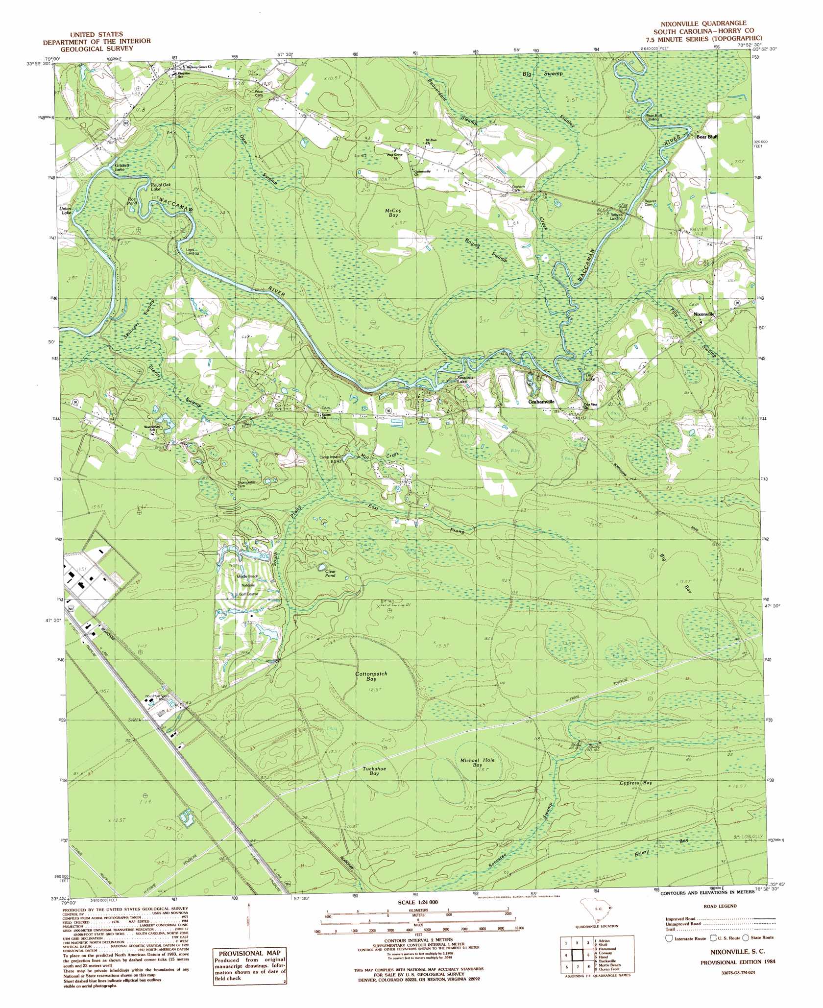
USGS Topo Quad 33078g8 - 1:24,000 scale
| Topo Map Name: | Nixonville |
| USGS Topo Quad ID: | 33078g8 |
| Print Size: | ca. 21 1/4" wide x 27" high |
| Southeast Coordinates: | 33.75° N latitude / 78.875° W longitude |
| Map Center Coordinates: | 33.8125° N latitude / 78.9375° W longitude |
| U.S. State: | SC |
| Filename: | o33078g8.jpg |
| Download Map JPG Image: | Nixonville topo map 1:24,000 scale |
| Map Type: | Topographic |
| Topo Series: | 7.5´ |
| Map Scale: | 1:24,000 |
| Source of Map Images: | United States Geological Survey (USGS) |
| Alternate Map Versions: |
Nixonville SC 1984, updated 1984 Download PDF Buy paper map Nixonville SC 2011 Download PDF Buy paper map Nixonville SC 2014 Download PDF Buy paper map |
1:24,000 Topo Quads surrounding Nixonville
Galivants Ferry |
Bayboro |
Loris |
Goretown |
Pireway |
Horry |
Adrian |
Shell |
Hammond |
Longs |
Dongola |
Conway |
Nixonville |
Hand |
Wampee |
Yauhannah |
Bucksville |
Myrtle Beach |
Ocean Forest |
|
Plantersville |
Brookgreen |
Surfside Beach |
> Back to 33078e1 at 1:100,000 scale
> Back to 33078a1 at 1:250,000 scale
> Back to U.S. Topo Maps home
Nixonville topo map: Gazetteer
Nixonville: Areas
The Wild Horse elevation 2m 6′Nixonville: Cliffs
Bear Bluff elevation 6m 19′Nixonville: Crossings
Hardees Ferry (historical) elevation 1m 3′Nixonville: Dams
Myrtle Beach National North Pond Dam D-3627 elevation 12m 39′South Carolina Noname 26037 D-3626 Dam elevation 13m 42′
Nixonville: Lakes
Clear Pond elevation 12m 39′Grissett Lake elevation 1m 3′
Roe Pond elevation 2m 6′
Royal Oak Lake elevation 1m 3′
Sessions Lake elevation 1m 3′
Tilly Lake elevation 1m 3′
Union Lake elevation 1m 3′
Nixonville: Parks
Cox Park elevation 10m 32′Nixonville: Populated Places
Fairtraid elevation 13m 42′Grahamville elevation 14m 45′
Jaluco elevation 13m 42′
Myrtle Trace elevation 12m 39′
Nixonville elevation 6m 19′
Vina elevation 11m 36′
Nixonville: Post Offices
Carolina Forest Post Office elevation 12m 39′Nixonville: Reservoirs
Myrtle Beach National Golf Number 10 Pond elevation 13m 42′Myrtle Beach National North Pond elevation 12m 39′
Nixonville: Streams
Beaverdam Swamp elevation 3m 9′Dam Swamp elevation 1m 3′
East Prong Steritt Swamp elevation 6m 19′
Jones Big Swamp elevation 1m 3′
Mill Creek elevation 5m 16′
South Prong Steritt Swamp elevation 7m 22′
Stanley Creek elevation 2m 6′
Tilly Swamp elevation 1m 3′
Nixonville: Swamps
Big Bay elevation 13m 42′Big Swamp elevation 3m 9′
Briery Bay elevation 10m 32′
Cottonpatch Bay elevation 12m 39′
Cypress Bay elevation 12m 39′
Loblolly Swamp elevation 10m 32′
Long Branch elevation 12m 39′
McCoy Bay elevation 7m 22′
Michael Hole Bay elevation 11m 36′
Round Swamp elevation 3m 9′
Skinners Swamp elevation 2m 6′
Tuckahoe Bay elevation 12m 39′
Nixonville digital topo map on disk
Buy this Nixonville topo map showing relief, roads, GPS coordinates and other geographical features, as a high-resolution digital map file on DVD:
South Carolina, Western North Carolina & Northeastern Georgia
Buy digital topo maps: South Carolina, Western North Carolina & Northeastern Georgia