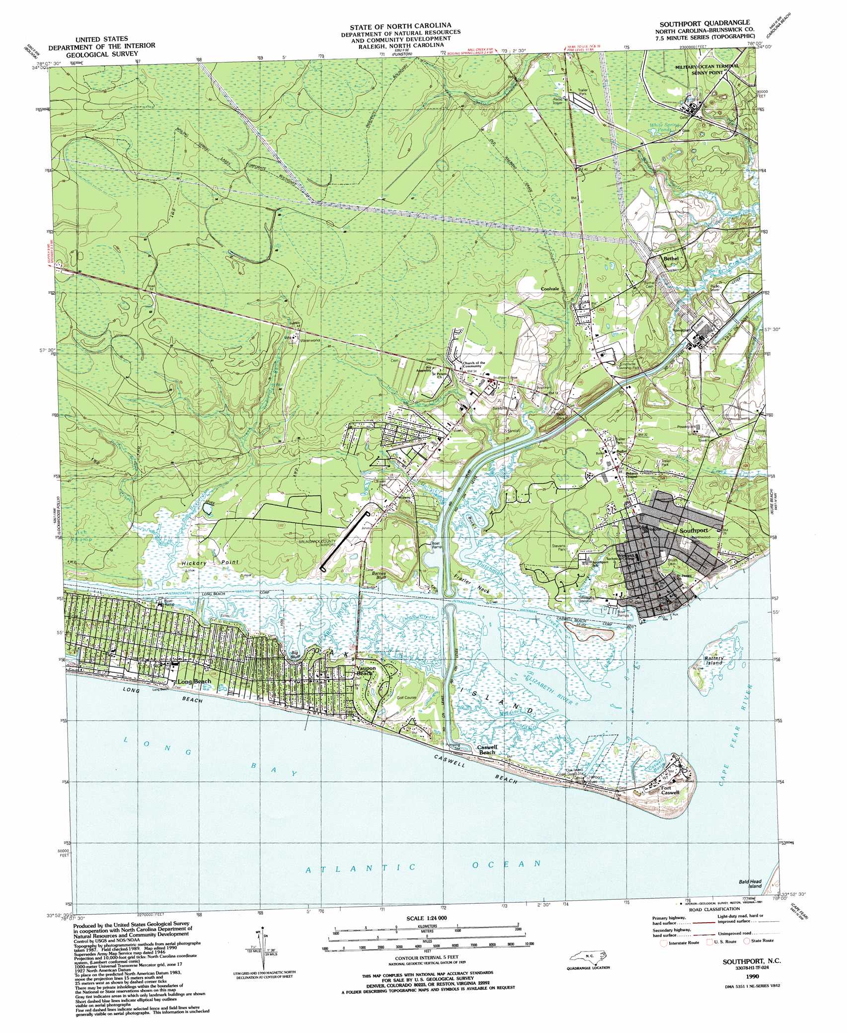
Southport Topo Map North Carolina
To zoom in, hover over the map of Southport
USGS Topo Quad 33078h1 - 1:24,000 scale
| Topo Map Name: | Southport |
| USGS Topo Quad ID: | 33078h1 |
| Print Size: | ca. 21 1/4" wide x 27" high |
| Southeast Coordinates: | 33.875° N latitude / 78° W longitude |
| Map Center Coordinates: | 33.9375° N latitude / 78.0625° W longitude |
| U.S. State: | NC |
| Filename: | o33078h1.jpg |
| Download Map JPG Image: | Southport topo map 1:24,000 scale |
| Map Type: | Topographic |
| Topo Series: | 7.5´ |
| Map Scale: | 1:24,000 |
| Source of Map Images: | United States Geological Survey (USGS) |
| Alternate Map Versions: |
Southport NC 1946 Download PDF Buy paper map Southport NC 1969 Download PDF Buy paper map Southport NC 1980, updated 1985 Download PDF Buy paper map Southport NC 1990, updated 1991 Download PDF Buy paper map Southport NC 2010 Download PDF Buy paper map Southport NC 2013 Download PDF Buy paper map Southport NC 2016 Download PDF Buy paper map |
1:24,000 Topo Quads surrounding Southport
Honey Island |
Lewis Swamp |
Winnabow |
Wilmington |
Wrightsville Beach |
Supply |
Bolivia |
Funston |
Carolina Beach |
|
Holden Beach |
Lockwoods Folly |
Southport |
Kure Beach |
|
Cape Fear |
||||
> Back to 33078e1 at 1:100,000 scale
> Back to 33078a1 at 1:250,000 scale
> Back to U.S. Topo Maps home
Southport topo map: Gazetteer
Southport: Airports
Brunswick County Airport elevation 6m 19′Southport: Bays
Caswell Basin elevation 0m 0′Jay Bird Shoals elevation 0m 0′
Southport: Beaches
Caswell Beach elevation 1m 3′Southport: Bridges
Orton Creek Bridge elevation 7m 22′Walden Bridge elevation 10m 32′
Southport: Capes
Frazier Neck elevation 1m 3′Hickory Point elevation 1m 3′
Southport: Channels
Baldhead Caswell elevation 0m 0′Battery Island Channel elevation 0m 0′
Lower Swash Channel Range elevation 0m 0′
Lower Swash Channel Range elevation 0m 0′
Smith Island Range elevation 0m 0′
Southport Channel elevation 0m 0′
Western Bar Channel elevation 0m 0′
Southport: Cliffs
Barnes Bluff elevation 3m 9′Big Bluff elevation 2m 6′
Southport: Guts
Denis Creek elevation 0m 0′Southport: Islands
Battery Island elevation 0m 0′Buck Island elevation 1m 3′
Oak Island elevation 2m 6′
Southport: Lakes
White Spring Ponds elevation 10m 32′Southport: Parks
Smithville Township District Park elevation 8m 26′Stevens Park elevation 6m 19′
Southport: Populated Places
Caswell Beach elevation 4m 13′Coolvale elevation 10m 32′
Fort Caswell elevation 2m 6′
Long Beach elevation 2m 6′
Saint James elevation 3m 9′
Southport elevation 5m 16′
Yaupon Beach elevation 6m 19′
Southport: Post Offices
Long Beach Post Office (historical) elevation 2m 6′Southport: Streams
Beaverdam Creek elevation 1m 3′Beaverdam Swamp elevation 1m 3′
Boathouse Creek elevation 0m 0′
Calf Gully Creek elevation 0m 0′
Cape Fear River elevation 0m 0′
Cottage Creek elevation 0m 0′
Coward Creek elevation 0m 0′
Denis Creek elevation 0m 0′
Denis Creek elevation 1m 3′
Doshers Creek elevation 0m 0′
Dutchman Creek elevation 0m 0′
Elizabeth River elevation 0m 0′
Jump and Run Creek elevation 1m 3′
Molasses Creek elevation 1m 3′
Piney Point Creek elevation 0m 0′
Polly Gully Creek elevation 0m 0′
Smokehouse Creek elevation 0m 0′
White Spring Creek elevation 0m 0′
Southport: Swamps
Ash Swamp elevation 4m 13′Southport digital topo map on disk
Buy this Southport topo map showing relief, roads, GPS coordinates and other geographical features, as a high-resolution digital map file on DVD:
South Carolina, Western North Carolina & Northeastern Georgia
Buy digital topo maps: South Carolina, Western North Carolina & Northeastern Georgia