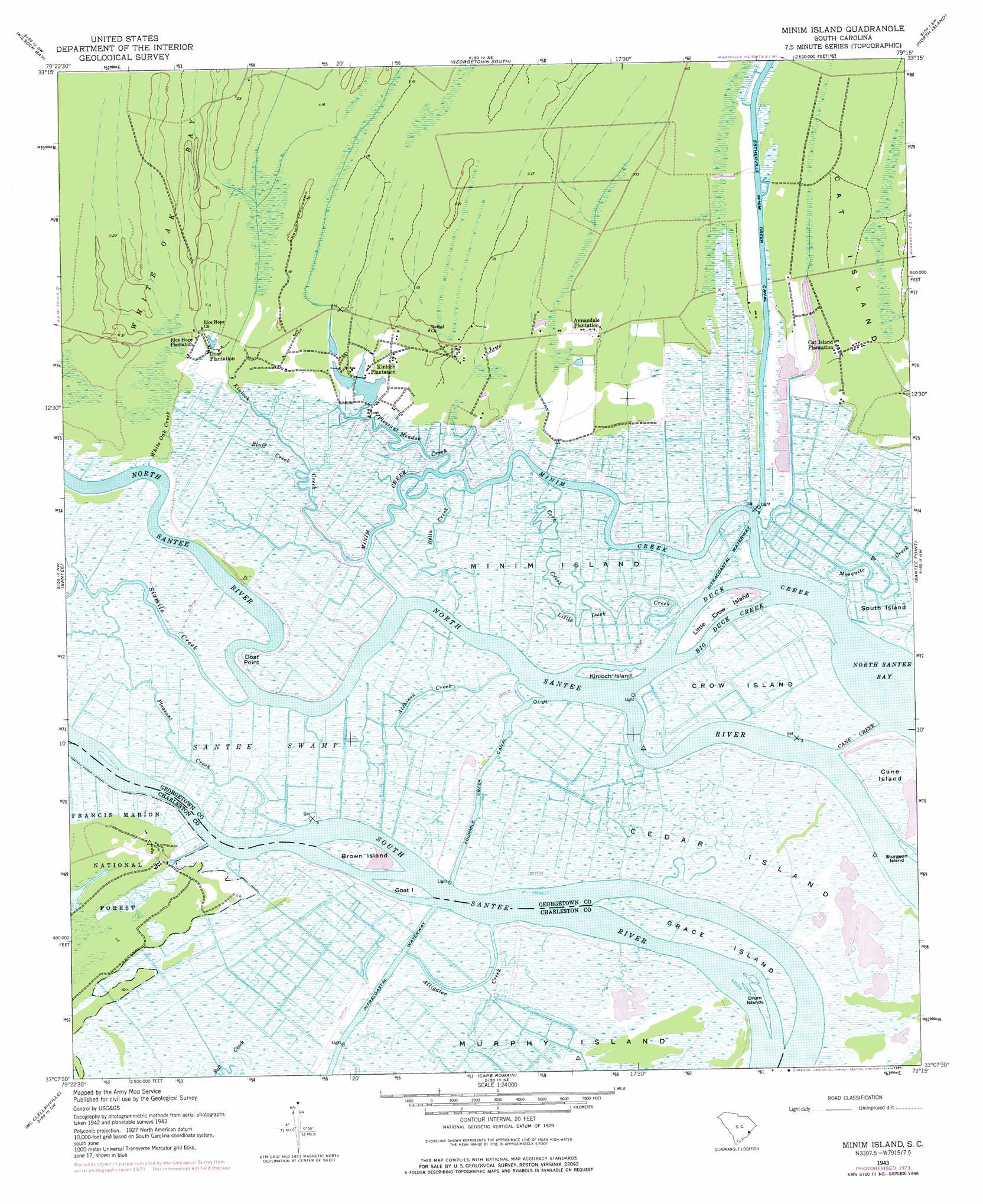
Minim Island Topo Map South Carolina
To zoom in, hover over the map of Minim Island
USGS Topo Quad 33079b3 - 1:24,000 scale
| Topo Map Name: | Minim Island |
| USGS Topo Quad ID: | 33079b3 |
| Print Size: | ca. 21 1/4" wide x 27" high |
| Southeast Coordinates: | 33.125° N latitude / 79.25° W longitude |
| Map Center Coordinates: | 33.1875° N latitude / 79.3125° W longitude |
| U.S. State: | SC |
| Filename: | o33079b3.jpg |
| Download Map JPG Image: | Minim Island topo map 1:24,000 scale |
| Map Type: | Topographic |
| Topo Series: | 7.5´ |
| Map Scale: | 1:24,000 |
| Source of Map Images: | United States Geological Survey (USGS) |
| Alternate Map Versions: |
Minim Island SC 1943, updated 1962 Download PDF Buy paper map Minim Island SC 1943, updated 1962 Download PDF Buy paper map Minim Island SC 1943, updated 1976 Download PDF Buy paper map Minim Island SC 1943, updated 1984 Download PDF Buy paper map Minim Island SC 1943, updated 1984 Download PDF Buy paper map Minim Island SC 2011 Download PDF Buy paper map Minim Island SC 2014 Download PDF Buy paper map |
| FStopo: | US Forest Service topo Minim Island is available: Download FStopo PDF Download FStopo TIF |
1:24,000 Topo Quads surrounding Minim Island
Andrews |
Olin |
Georgetown North |
Waverly Mills |
Magnolia Beach |
Cedar Creek |
Kilsock Bay |
Georgetown South |
North Island |
|
Honey Hill |
Santee |
Minim Island |
Santee Point |
|
Awendaw |
Mcclellanville |
Cape Romain |
||
Bull Island |
> Back to 33079a1 at 1:100,000 scale
> Back to 33078a1 at 1:250,000 scale
> Back to U.S. Topo Maps home
Minim Island topo map: Gazetteer
Minim Island: Canals
Estherville Minim Creek Canal elevation 0m 0′Fourmile Creek Canal elevation 10m 32′
Minim Island: Capes
Doar Point elevation 0m 0′Minim Island: Guts
Alligator Creek elevation 0m 0′Atchison Creek elevation 1m 3′
Cane Creek elevation 0m 0′
Minim Creek elevation -2m -7′
Minim Island: Islands
Brown Island elevation 1m 3′Cane Island elevation 1m 3′
Cedar Island elevation 1m 3′
Crow Island elevation 1m 3′
Drum Islands elevation 0m 0′
Goat Island elevation 1m 3′
Grace Island elevation 1m 3′
Kinloch Island elevation 1m 3′
Little Crow Island elevation 1m 3′
Minim Island elevation 1m 3′
Sturgeon Island elevation 1m 3′
Minim Island: Parks
Santee Coastal Reserve elevation 1m 3′Minim Island: Streams
Big Duck Creek elevation 1m 3′Bluff Creek elevation 1m 3′
Cork Creek elevation 0m 0′
Duck Creek elevation 0m 0′
Kinloch Creek elevation 0m 0′
Little Duck Creek elevation 1m 3′
Pleasant Creek elevation 1m 3′
Pleasant Meadow Creek elevation 0m 0′
Sand Creek elevation 0m 0′
Sixmile Creek elevation -1m -4′
White Oak Creek elevation 1m 3′
Minim Island digital topo map on disk
Buy this Minim Island topo map showing relief, roads, GPS coordinates and other geographical features, as a high-resolution digital map file on DVD:
South Carolina, Western North Carolina & Northeastern Georgia
Buy digital topo maps: South Carolina, Western North Carolina & Northeastern Georgia