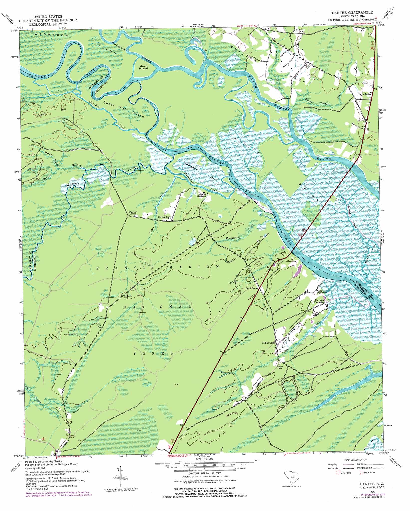
Santee Topo Map South Carolina
To zoom in, hover over the map of Santee
USGS Topo Quad 33079b4 - 1:24,000 scale
| Topo Map Name: | Santee |
| USGS Topo Quad ID: | 33079b4 |
| Print Size: | ca. 21 1/4" wide x 27" high |
| Southeast Coordinates: | 33.125° N latitude / 79.375° W longitude |
| Map Center Coordinates: | 33.1875° N latitude / 79.4375° W longitude |
| U.S. State: | SC |
| Filename: | o33079b4.jpg |
| Download Map JPG Image: | Santee topo map 1:24,000 scale |
| Map Type: | Topographic |
| Topo Series: | 7.5´ |
| Map Scale: | 1:24,000 |
| Source of Map Images: | United States Geological Survey (USGS) |
| Alternate Map Versions: |
Santee SC 1943, updated 1962 Download PDF Buy paper map Santee SC 1943, updated 1976 Download PDF Buy paper map South Santee SC 1943, updated 1976 Download PDF Buy paper map South Santee SC 2011 Download PDF Buy paper map South Santee SC 2014 Download PDF Buy paper map |
| FStopo: | US Forest Service topo South Santee is available: Download FStopo PDF Download FStopo TIF |
1:24,000 Topo Quads surrounding Santee
Trio |
Andrews |
Olin |
Georgetown North |
Waverly Mills |
Jamestown |
Cedar Creek |
Kilsock Bay |
Georgetown South |
North Island |
Shulerville |
Honey Hill |
Santee |
Minim Island |
Santee Point |
Ocean Bay |
Awendaw |
Mcclellanville |
Cape Romain |
|
Sewee Bay |
Bull Island |
> Back to 33079a1 at 1:100,000 scale
> Back to 33078a1 at 1:250,000 scale
> Back to U.S. Topo Maps home
Santee topo map: Gazetteer
Santee: Bridges
John T Stevens Memorial Bridge elevation 0m 0′Santee: Crossings
Lynches Ferry (historical) elevation 3m 9′Mazycks Ferry (historical) elevation 0m 0′
Water Horn Ferry (historical) elevation 4m 13′
Santee: Guts
Push and Go Creek elevation 4m 13′Santee: Islands
Cedar Hill Island elevation 3m 9′Daniels Island elevation 3m 9′
Goat Island elevation 6m 19′
Hampton Island elevation 1m 3′
Santee: Parks
Hampton Plantation State Park elevation 6m 19′Santee Park elevation 6m 19′
Santee: Populated Places
Collins Creek elevation 6m 19′Crow Hill elevation 5m 16′
Germantown elevation 6m 19′
North Santee elevation 6m 19′
South Santee elevation 6m 19′
Wambaw Corner elevation 6m 19′
Santee: Streams
Big Morgan Branch elevation 3m 9′Bonny Clabber Creek elevation 0m 0′
Bouman Branch elevation 6m 19′
Cedar Creek elevation 4m 13′
Chicken Creek elevation 0m 0′
Collins Creek elevation 1m 3′
Garfish Creek elevation 1m 3′
Hampton Creek elevation 3m 9′
Little Morgan Branch elevation 3m 9′
Montgomery Creek elevation 2m 6′
Pole Branch elevation 3m 9′
Santee River elevation 3m 9′
Wadmacon Creek elevation 3m 9′
Wambaw Creek elevation 0m 0′
Santee: Summits
Cedar Hill elevation 6m 19′Santee: Swamps
Washo Reserve elevation 1m 3′Santee digital topo map on disk
Buy this Santee topo map showing relief, roads, GPS coordinates and other geographical features, as a high-resolution digital map file on DVD:
South Carolina, Western North Carolina & Northeastern Georgia
Buy digital topo maps: South Carolina, Western North Carolina & Northeastern Georgia