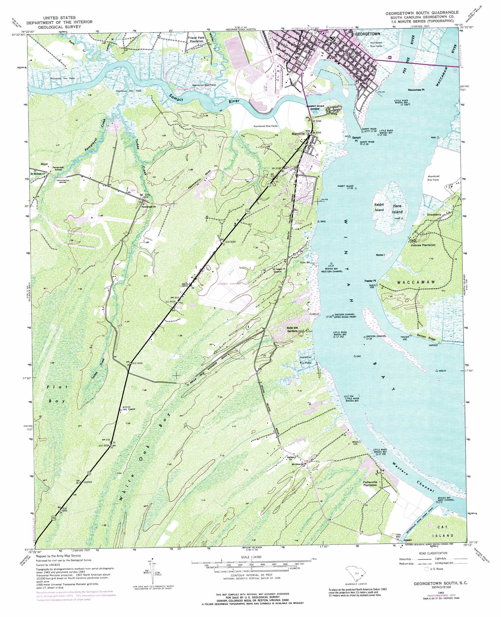
Georgetown South Topo Map South Carolina
To zoom in, hover over the map of Georgetown South
USGS Topo Quad 33079c3 - 1:24,000 scale
| Topo Map Name: | Georgetown South |
| USGS Topo Quad ID: | 33079c3 |
| Print Size: | ca. 21 1/4" wide x 27" high |
| Southeast Coordinates: | 33.25° N latitude / 79.25° W longitude |
| Map Center Coordinates: | 33.3125° N latitude / 79.3125° W longitude |
| U.S. State: | SC |
| Filename: | o33079c3.jpg |
| Download Map JPG Image: | Georgetown South topo map 1:24,000 scale |
| Map Type: | Topographic |
| Topo Series: | 7.5´ |
| Map Scale: | 1:24,000 |
| Source of Map Images: | United States Geological Survey (USGS) |
| Alternate Map Versions: |
Georgetown South SC 1943, updated 1976 Download PDF Buy paper map Georgetown South SC 1943, updated 1989 Download PDF Buy paper map Georgetown South SC 1947 Download PDF Buy paper map Georgetown South SC 1968 Download PDF Buy paper map Georgetown South SC 2011 Download PDF Buy paper map Georgetown South SC 2014 Download PDF Buy paper map |
1:24,000 Topo Quads surrounding Georgetown South
Warsaw |
Rhems |
Carvers Bay |
Plantersville |
Brookgreen |
Andrews |
Olin |
Georgetown North |
Waverly Mills |
Magnolia Beach |
Cedar Creek |
Kilsock Bay |
Georgetown South |
North Island |
|
Honey Hill |
Santee |
Minim Island |
Santee Point |
|
Awendaw |
Mcclellanville |
Cape Romain |
> Back to 33079a1 at 1:100,000 scale
> Back to 33078a1 at 1:250,000 scale
> Back to U.S. Topo Maps home
Georgetown South topo map: Gazetteer
Georgetown South: Airports
Georgetown County Airport elevation 6m 19′Georgetown South: Bridges
L H Siau Bridge elevation 1m 3′Pennyroyal Bridge elevation 4m 13′
Sampit River Bridge elevation 0m 0′
Georgetown South: Capes
Frazier Point elevation 0m 0′Sampit Point elevation 0m 0′
Waccamaw Point elevation 0m 0′
Georgetown South: Channels
Western Channel elevation 0m 0′Georgetown South: Crossings
Sampit Ferry (historical) elevation 0m 0′South Island Ferry elevation 3m 9′
Georgetown South: Dams
Ip Two Waste Pond Dam D-3587 elevation 4m 13′Ip Waste Pond Dam Number One D-3586 elevation 4m 13′
South Carolina Noname 22016 D-3585 Dam elevation 1m 3′
Georgetown South: Islands
Hare Island elevation 1m 3′Horse Island elevation 1m 3′
Middle Ground elevation 1m 3′
Rabbit Island elevation 1m 3′
Georgetown South: Parks
Belle Isle Park elevation 6m 19′East Bay Park elevation 1m 3′
Francis Marion Park elevation 4m 13′
Georgetown Historic District elevation 4m 13′
Lafayette Park elevation 0m 0′
Maryville Park elevation 3m 9′
Morgan Park elevation 1m 3′
Georgetown South: Populated Places
Belle Isle Estates elevation 6m 19′Belle Isle Gardens elevation 4m 13′
Maryville elevation 6m 19′
Moyd elevation 4m 13′
San Miguel De Gualdape (historical) elevation 3m 9′
Steele Town elevation 4m 13′
Strawberry elevation 5m 16′
White Hall Estates elevation 4m 13′
Georgetown South: Post Offices
Georgetown Post Office elevation 5m 16′Georgetown South: Ridges
Barnes Ridge elevation 1m 3′Georgetown South: Streams
Canaan Branch elevation 2m 6′Great Pee Dee River elevation 0m 0′
Pennyroyal Creek elevation 6m 19′
Ports Creek elevation 1m 3′
Sampit River elevation 0m 0′
Turkey Creek elevation 1m 3′
Waccamaw River elevation 0m 0′
Whites Creek elevation 1m 3′
Georgetown South: Swamps
Flat Bay elevation 7m 22′White Oak Bay elevation 7m 22′
Georgetown South digital topo map on disk
Buy this Georgetown South topo map showing relief, roads, GPS coordinates and other geographical features, as a high-resolution digital map file on DVD:
South Carolina, Western North Carolina & Northeastern Georgia
Buy digital topo maps: South Carolina, Western North Carolina & Northeastern Georgia