Kellehan Crossroads Topo Map South Carolina
To zoom in, hover over the map of Kellehan Crossroads
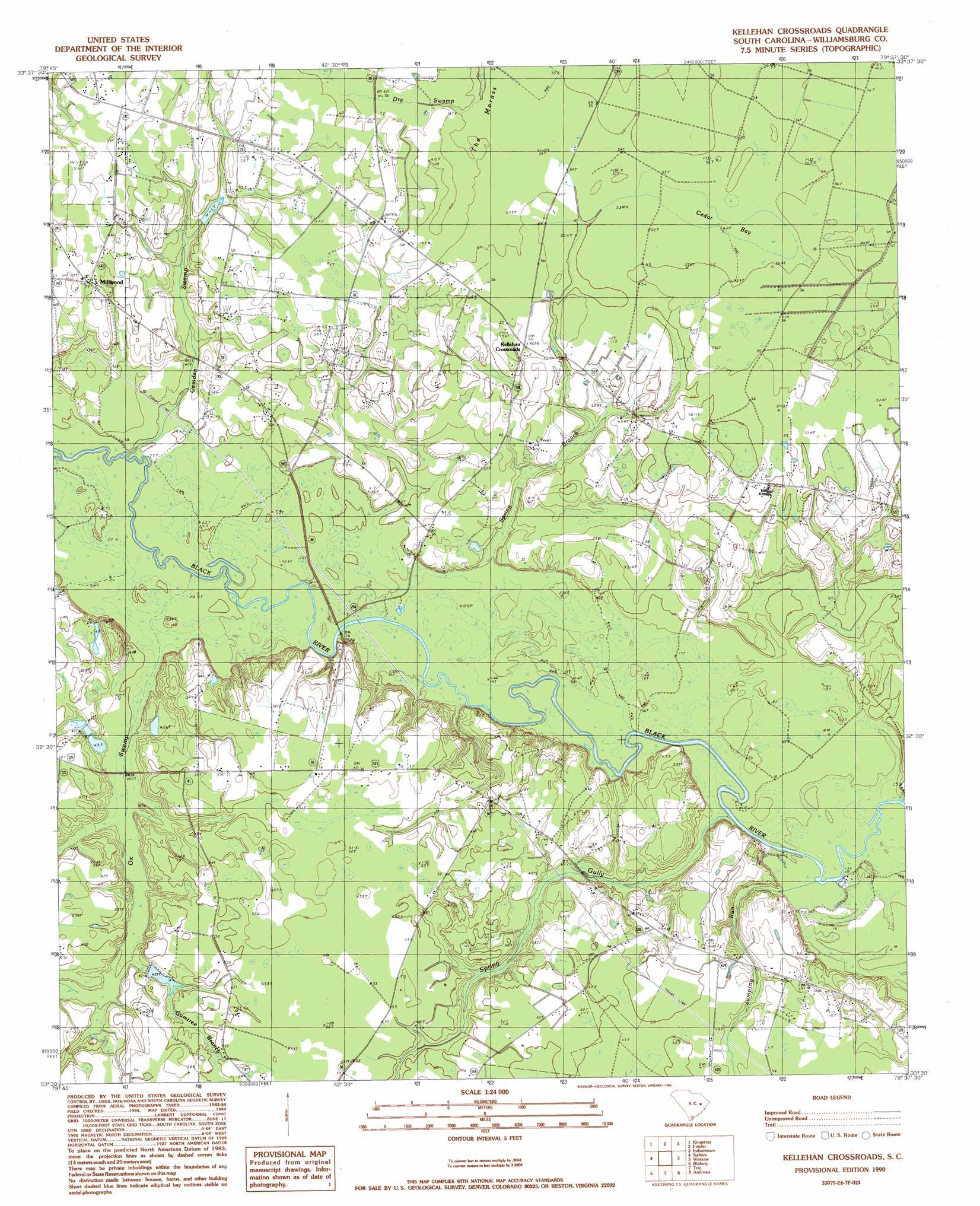
USGS Topo Quad 33079e6 - 1:24,000 scale
| Topo Map Name: | Kellehan Crossroads |
| USGS Topo Quad ID: | 33079e6 |
| Print Size: | ca. 21 1/4" wide x 27" high |
| Southeast Coordinates: | 33.5° N latitude / 79.625° W longitude |
| Map Center Coordinates: | 33.5625° N latitude / 79.6875° W longitude |
| U.S. State: | SC |
| Filename: | o33079e6.jpg |
| Download Map JPG Image: | Kellehan Crossroads topo map 1:24,000 scale |
| Map Type: | Topographic |
| Topo Series: | 7.5´ |
| Map Scale: | 1:24,000 |
| Source of Map Images: | United States Geological Survey (USGS) |
| Alternate Map Versions: |
Kellehan Crossroads SC 1990, updated 1990 Download PDF Buy paper map Kellehan Crossroads SC 2011 Download PDF Buy paper map Kellehan Crossroads SC 2014 Download PDF Buy paper map |
1:24,000 Topo Quads surrounding Kellehan Crossroads
Hebron Crossroads |
Lake City West |
Lake City East |
Prospect Crossroads |
Johnsonville |
Workman |
Kingstree |
Fowler |
Indiantown |
Henry |
Greeleyville |
Salters |
Kellehan Crossroads |
Warsaw |
Rhems |
Saint Stephens |
Blakely |
Trio |
Andrews |
Olin |
Bonneau |
Wedboo Creek |
Jamestown |
Cedar Creek |
Kilsock Bay |
> Back to 33079e1 at 1:100,000 scale
> Back to 33078a1 at 1:250,000 scale
> Back to U.S. Topo Maps home
Kellehan Crossroads topo map: Gazetteer
Kellehan Crossroads: Crossings
Hicksons Ferry (historical) elevation 7m 22′Lower Crossing elevation 8m 26′
Kellehan Crossroads: Dams
A H Parsons Pond Dam D-3088 elevation 11m 36′McCollough Upper Pond Dam D-3091 elevation 11m 36′
Scott Pond Dam D-3087 elevation 14m 45′
South Carolina Noname 45006 D-3092 Dam elevation 9m 29′
South Carolina Noname 45015 D-3093 Dam elevation 14m 45′
Kellehan Crossroads: Populated Places
Kellehan Crossroads elevation 17m 55′Millwood elevation 18m 59′
Kellehan Crossroads: Reservoirs
Parsons Pond elevation 11m 36′Scott Pond elevation 14m 45′
Sheppard Pond elevation 14m 45′
Kellehan Crossroads: Streams
Camden Swamp elevation 6m 19′Gumtree Branch elevation 17m 55′
Gumtree Branch elevation 8m 26′
Jumping Run elevation 4m 13′
McElroy Branch elevation 6m 19′
Ox Swamp elevation 6m 19′
Spring Branch elevation 5m 16′
Kellehan Crossroads: Swamps
Cedar Bay elevation 16m 52′The Morass elevation 15m 49′
Kellehan Crossroads: Valleys
Spring Gully elevation 5m 16′Kellehan Crossroads digital topo map on disk
Buy this Kellehan Crossroads topo map showing relief, roads, GPS coordinates and other geographical features, as a high-resolution digital map file on DVD:
South Carolina, Western North Carolina & Northeastern Georgia
Buy digital topo maps: South Carolina, Western North Carolina & Northeastern Georgia