Yauhannah Topo Map South Carolina
To zoom in, hover over the map of Yauhannah
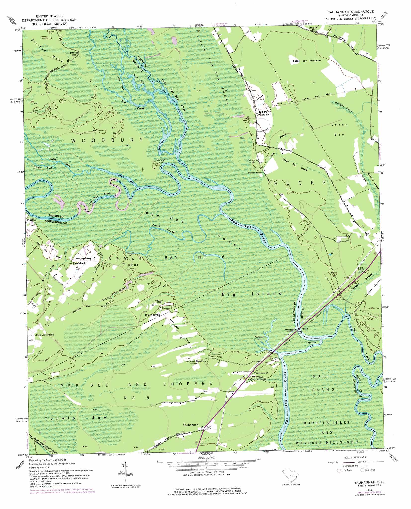
USGS Topo Quad 33079f2 - 1:24,000 scale
| Topo Map Name: | Yauhannah |
| USGS Topo Quad ID: | 33079f2 |
| Print Size: | ca. 21 1/4" wide x 27" high |
| Southeast Coordinates: | 33.625° N latitude / 79.125° W longitude |
| Map Center Coordinates: | 33.6875° N latitude / 79.1875° W longitude |
| U.S. State: | SC |
| Filename: | o33079f2.jpg |
| Download Map JPG Image: | Yauhannah topo map 1:24,000 scale |
| Map Type: | Topographic |
| Topo Series: | 7.5´ |
| Map Scale: | 1:24,000 |
| Source of Map Images: | United States Geological Survey (USGS) |
| Alternate Map Versions: |
Yauhannah SC 1943, updated 1958 Download PDF Buy paper map Yauhannah SC 1943, updated 1973 Download PDF Buy paper map Yauhannah SC 1943, updated 1977 Download PDF Buy paper map Yauhannah SC 2011 Download PDF Buy paper map Yauhannah SC 2014 Download PDF Buy paper map |
1:24,000 Topo Quads surrounding Yauhannah
Gresham |
Britton Neck |
Horry |
Adrian |
Shell |
Johnsonville |
Snow Island |
Dongola |
Conway |
Nixonville |
Henry |
Outland |
Yauhannah |
Bucksville |
Myrtle Beach |
Rhems |
Carvers Bay |
Plantersville |
Brookgreen |
Surfside Beach |
Olin |
Georgetown North |
Waverly Mills |
Magnolia Beach |
> Back to 33079e1 at 1:100,000 scale
> Back to 33078a1 at 1:250,000 scale
> Back to U.S. Topo Maps home
Yauhannah topo map: Gazetteer
Yauhannah: Basins
Lucas Bay elevation 5m 16′Yauhannah: Bridges
Bradley Bridge elevation 5m 16′Yauhannah Bridge elevation 1m 3′
Yauhannah: Capes
Hell Gate elevation 1m 3′Yauhannah: Channels
Hell Gate elevation 1m 3′Yauhannah: Crossings
Port Harrelson Ferry (historical) elevation 1m 3′Yahany Ferry (historical) elevation 1m 3′
Yauhannah: Islands
Big Island elevation 1m 3′Yauhannah: Lakes
Black Lake elevation 1m 3′Eddy Lake elevation 2m 6′
Jordan Lake elevation 1m 3′
Russ Lake elevation 1m 3′
Yauhannah Lake elevation 1m 3′
Yauhannah: Parks
Pee Dee Park elevation 12m 39′Yauhannah: Populated Places
Conch Creek elevation 12m 39′Gilbert Crossroads elevation 6m 19′
Petersfield elevation 12m 39′
Rice Crossroads elevation 13m 42′
Yauhannah elevation 6m 19′
Yauhannah: Streams
Bradley Branch elevation 1m 3′Conch Creek elevation 1m 3′
Cowford Swamp elevation 1m 3′
Dead River elevation 1m 3′
Horsepen Branch elevation 5m 16′
Jacobs Creek elevation 1m 3′
Jiles Creek elevation 1m 3′
Jordan Creek elevation 1m 3′
Little Pee Dee River elevation 1m 3′
Russ Creek elevation 1m 3′
Sally Branch elevation 1m 3′
Sheep Pen Branch elevation 5m 16′
Yauhannah Creek elevation 1m 3′
Yauhannah: Summits
High Hill elevation 12m 39′Yauhannah: Swamps
Pee Dee Swamp elevation 1m 3′Tupelo Bay elevation 6m 19′
Yauhannah: Valleys
Gravel Gully elevation 1m 3′Larrimore Gully elevation 3m 9′
Yauhannah digital topo map on disk
Buy this Yauhannah topo map showing relief, roads, GPS coordinates and other geographical features, as a high-resolution digital map file on DVD:
South Carolina, Western North Carolina & Northeastern Georgia
Buy digital topo maps: South Carolina, Western North Carolina & Northeastern Georgia