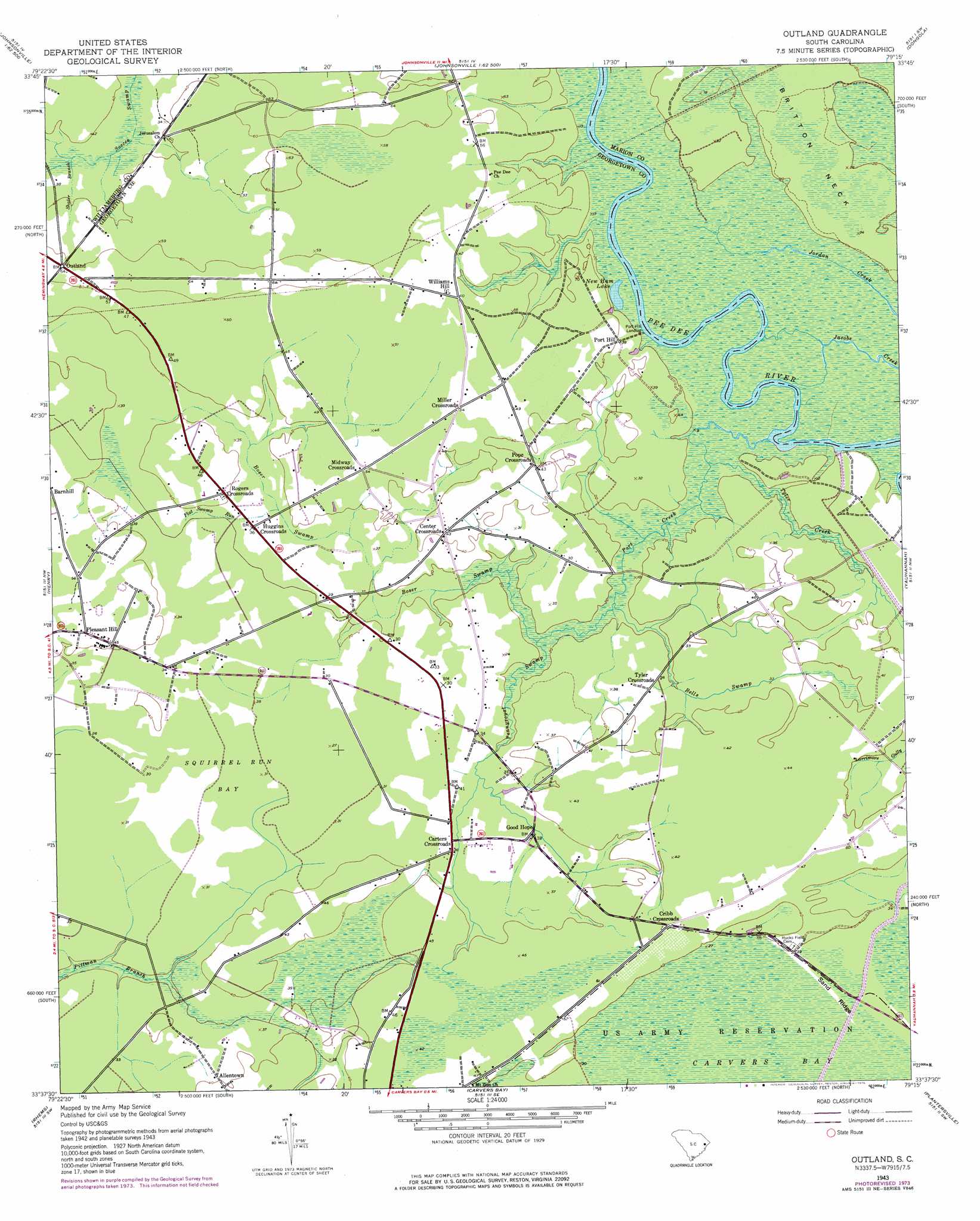
Outland Topo Map South Carolina
To zoom in, hover over the map of Outland
USGS Topo Quad 33079f3 - 1:24,000 scale
| Topo Map Name: | Outland |
| USGS Topo Quad ID: | 33079f3 |
| Print Size: | ca. 21 1/4" wide x 27" high |
| Southeast Coordinates: | 33.625° N latitude / 79.25° W longitude |
| Map Center Coordinates: | 33.6875° N latitude / 79.3125° W longitude |
| U.S. State: | SC |
| Filename: | o33079f3.jpg |
| Download Map JPG Image: | Outland topo map 1:24,000 scale |
| Map Type: | Topographic |
| Topo Series: | 7.5´ |
| Map Scale: | 1:24,000 |
| Source of Map Images: | United States Geological Survey (USGS) |
| Alternate Map Versions: |
Outland SC 1943, updated 1962 Download PDF Buy paper map Outland SC 1943, updated 1976 Download PDF Buy paper map Outland SC 2011 Download PDF Buy paper map Outland SC 2014 Download PDF Buy paper map |
1:24,000 Topo Quads surrounding Outland
Pamplico South |
Gresham |
Britton Neck |
Horry |
Adrian |
Prospect Crossroads |
Johnsonville |
Snow Island |
Dongola |
Conway |
Indiantown |
Henry |
Outland |
Yauhannah |
Bucksville |
Warsaw |
Rhems |
Carvers Bay |
Plantersville |
Brookgreen |
Andrews |
Olin |
Georgetown North |
Waverly Mills |
Magnolia Beach |
> Back to 33079e1 at 1:100,000 scale
> Back to 33078a1 at 1:250,000 scale
> Back to U.S. Topo Maps home
Outland topo map: Gazetteer
Outland: Basins
Squirrel Run Bay elevation 9m 29′Outland: Capes
Britton Neck elevation 6m 19′Outland: Lakes
New Ham Lake elevation 5m 16′Outland: Populated Places
Allentown elevation 12m 39′Carters Crossroads elevation 11m 36′
Center Crossroads elevation 12m 39′
Cribb Crossroads elevation 12m 39′
Good Hope elevation 12m 39′
Huggins Crossroads elevation 10m 32′
Midway Crossroads elevation 16m 52′
Miller Crossroads elevation 15m 49′
Outland elevation 19m 62′
Pleasant Hill elevation 12m 39′
Pope Crossroads elevation 12m 39′
Port Hill elevation 12m 39′
Port Hill Landing elevation 5m 16′
Rogers Crossroads elevation 12m 39′
Tyler Crossroads elevation 9m 29′
Williams Hill elevation 13m 42′
Outland: Ridges
Sand Ridge elevation 12m 39′Outland: Streams
Bells Swamp elevation 6m 19′Boser Swamp elevation 6m 19′
Flat Swamp Run elevation 9m 29′
Pennyroyal Swamp elevation 6m 19′
Port Creek elevation 6m 19′
Shaler Branch elevation 12m 39′
Tyler Creek elevation 5m 16′
Outland digital topo map on disk
Buy this Outland topo map showing relief, roads, GPS coordinates and other geographical features, as a high-resolution digital map file on DVD:
South Carolina, Western North Carolina & Northeastern Georgia
Buy digital topo maps: South Carolina, Western North Carolina & Northeastern Georgia