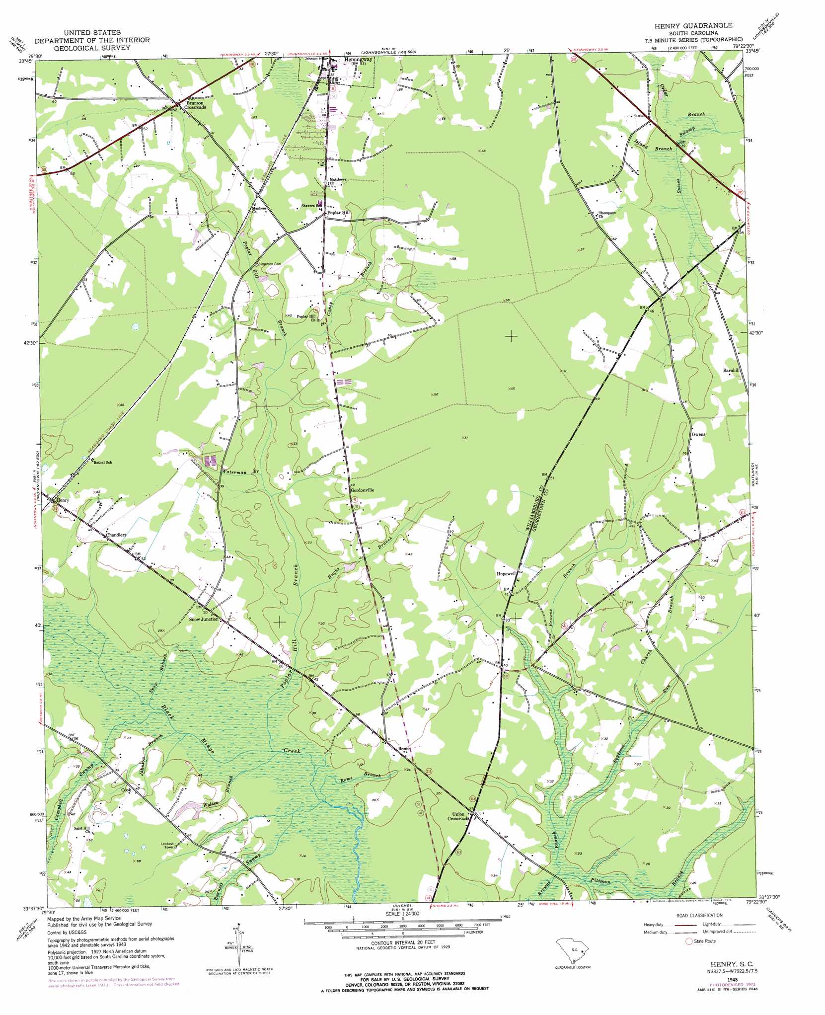
Henry Topo Map South Carolina
To zoom in, hover over the map of Henry
USGS Topo Quad 33079f4 - 1:24,000 scale
| Topo Map Name: | Henry |
| USGS Topo Quad ID: | 33079f4 |
| Print Size: | ca. 21 1/4" wide x 27" high |
| Southeast Coordinates: | 33.625° N latitude / 79.375° W longitude |
| Map Center Coordinates: | 33.6875° N latitude / 79.4375° W longitude |
| U.S. State: | SC |
| Filename: | o33079f4.jpg |
| Download Map JPG Image: | Henry topo map 1:24,000 scale |
| Map Type: | Topographic |
| Topo Series: | 7.5´ |
| Map Scale: | 1:24,000 |
| Source of Map Images: | United States Geological Survey (USGS) |
| Alternate Map Versions: |
Henry SC 1943, updated 1962 Download PDF Buy paper map Henry SC 1943, updated 1976 Download PDF Buy paper map Henry SC 2011 Download PDF Buy paper map Henry SC 2014 Download PDF Buy paper map |
1:24,000 Topo Quads surrounding Henry
Scranton |
Pamplico South |
Gresham |
Britton Neck |
Horry |
Lake City East |
Prospect Crossroads |
Johnsonville |
Snow Island |
Dongola |
Fowler |
Indiantown |
Henry |
Outland |
Yauhannah |
Kellehan Crossroads |
Warsaw |
Rhems |
Carvers Bay |
Plantersville |
Trio |
Andrews |
Olin |
Georgetown North |
Waverly Mills |
> Back to 33079e1 at 1:100,000 scale
> Back to 33078a1 at 1:250,000 scale
> Back to U.S. Topo Maps home
Henry topo map: Gazetteer
Henry: Dams
Brockington Pond Dam D-3100 elevation 9m 29′Henry: Populated Places
Barnhill elevation 11m 36′Brunson Crossroads elevation 14m 45′
Chandlers elevation 13m 42′
Cook elevation 12m 39′
Gordonville elevation 15m 49′
Henry elevation 13m 42′
Hopewell elevation 15m 49′
Owens elevation 12m 39′
Poplar Hill elevation 15m 49′
Rome elevation 11m 36′
Snow Junction elevation 11m 36′
Union Crossroads elevation 10m 32′
Henry: Reservoirs
Brockington Pond elevation 9m 29′Henry: Streams
Burnett Swamp elevation 6m 19′Campbell Swamp elevation 6m 19′
Caney Branch elevation 7m 22′
Cedar Branch elevation 12m 39′
Church Branch elevation 6m 19′
Headless Creek elevation 3m 9′
Hughs Branch elevation 6m 19′
Island Branch elevation 12m 39′
Johnson Branch elevation 5m 16′
Pittman Branch elevation 6m 19′
Poplar Hill Branch elevation 6m 19′
Rome Branch elevation 6m 19′
Snow Branch elevation 5m 16′
Squirrel Run elevation 6m 19′
Walden Branch elevation 6m 19′
Waterman Branch elevation 6m 19′
Henry digital topo map on disk
Buy this Henry topo map showing relief, roads, GPS coordinates and other geographical features, as a high-resolution digital map file on DVD:
South Carolina, Western North Carolina & Northeastern Georgia
Buy digital topo maps: South Carolina, Western North Carolina & Northeastern Georgia