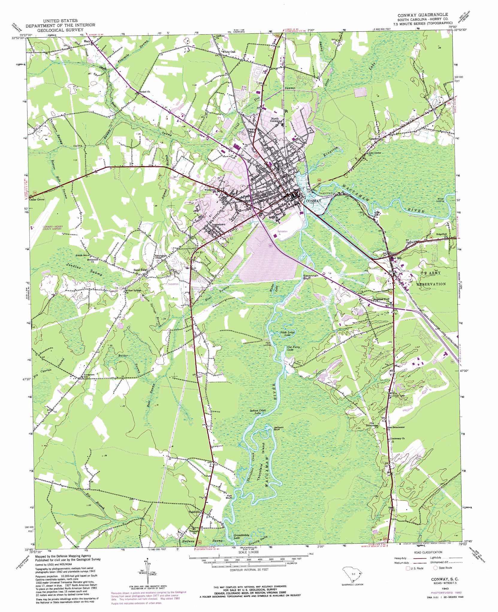
Conway Topo Map South Carolina
To zoom in, hover over the map of Conway
USGS Topo Quad 33079g1 - 1:24,000 scale
| Topo Map Name: | Conway |
| USGS Topo Quad ID: | 33079g1 |
| Print Size: | ca. 21 1/4" wide x 27" high |
| Southeast Coordinates: | 33.75° N latitude / 79° W longitude |
| Map Center Coordinates: | 33.8125° N latitude / 79.0625° W longitude |
| U.S. State: | SC |
| Filename: | o33079g1.jpg |
| Download Map JPG Image: | Conway topo map 1:24,000 scale |
| Map Type: | Topographic |
| Topo Series: | 7.5´ |
| Map Scale: | 1:24,000 |
| Source of Map Images: | United States Geological Survey (USGS) |
| Alternate Map Versions: |
Conway SC 1943, updated 1962 Download PDF Buy paper map Conway SC 1943, updated 1974 Download PDF Buy paper map Conway SC 1943, updated 1980 Download PDF Buy paper map Conway SC 2011 Download PDF Buy paper map Conway SC 2014 Download PDF Buy paper map |
1:24,000 Topo Quads surrounding Conway
Centenary |
Galivants Ferry |
Bayboro |
Loris |
Goretown |
Britton Neck |
Horry |
Adrian |
Shell |
Hammond |
Snow Island |
Dongola |
Conway |
Nixonville |
Hand |
Outland |
Yauhannah |
Bucksville |
Myrtle Beach |
Ocean Forest |
Carvers Bay |
Plantersville |
Brookgreen |
Surfside Beach |
> Back to 33079e1 at 1:100,000 scale
> Back to 33078a1 at 1:250,000 scale
> Back to U.S. Topo Maps home
Conway topo map: Gazetteer
Conway: Airports
Conway-Horry County Airport elevation 10m 32′Conway: Cliffs
Jackson Bluff elevation 1m 3′Pott Bluff elevation 1m 3′
Savannah Bluff elevation 1m 3′
Conway: Crossings
Coxs Ferry (historical) elevation 1m 3′Conway: Dams
Conway Oxidation Pond Number One Dam D-3625 elevation 4m 13′Conway Oxidation Pond Number Two Dam D-3624 elevation 5m 16′
Conway: Islands
Thorofare Island elevation 2m 6′Conway: Lakes
Cox Ferry Lake elevation 1m 3′Granddaddy Lake elevation 1m 3′
Indian Creek Lake elevation 1m 3′
Pitch Lodge Lake elevation 3m 9′
Wadus Lake elevation 4m 13′
Conway: Parks
Coastal Carolina University Brooks Stadium elevation 12m 39′Coastal Carolina University Williams - Brice Building - Kimbel Arena elevation 12m 39′
Conway: Populated Places
Buckwood elevation 10m 32′Burning Ridge elevation 12m 39′
Cedar Grove elevation 9m 29′
Chicora elevation 6m 19′
Coastal Heights elevation 12m 39′
Cochran Town elevation 8m 26′
College Park elevation 12m 39′
Conway elevation 10m 32′
Country Club Forest elevation 4m 13′
Crosswinds elevation 12m 39′
Darden Terrace elevation 6m 19′
El Bethel elevation 8m 26′
Greenbriar elevation 8m 26′
Grissett elevation 6m 19′
Huckabee Heights elevation 13m 42′
Jamestown elevation 14m 45′
Longwood elevation 7m 22′
Mary elevation 11m 36′
North Conway elevation 5m 16′
Park Hill elevation 6m 19′
Pine Valley Estates elevation 12m 39′
Pinewood elevation 9m 29′
Pitch Landing elevation 1m 3′
Quattlebaum Acres elevation 13m 42′
Red Hill elevation 10m 32′
Sand Ridge elevation 13m 42′
Toddville elevation 5m 16′
University Forest elevation 12m 39′
White Oak elevation 7m 22′
Whittemore Park elevation 14m 45′
Wilson Landing elevation 1m 3′
Conway: Post Offices
Conway Post Office elevation 9m 29′Conway: Reservoirs
Conway Oxidation Pond Number One elevation 4m 13′Conway Oxidation Pond Number Two elevation 5m 16′
Conway: Streams
Altman Branch elevation 5m 16′Bear Swamp elevation 4m 13′
Beaver Hole Swamp elevation 9m 29′
Big Branch elevation 5m 16′
Brown Swamp elevation 5m 16′
Crab Tree Swamp elevation 4m 13′
Fourmile Swamp elevation 6m 19′
Gravely Gully elevation 1m 3′
Grier Swamp elevation 4m 13′
Kingston Lake elevation 1m 3′
Ned Creek elevation 10m 32′
Ned Creek elevation 11m 36′
Oakey Swamp elevation 5m 16′
Steritt Swamp elevation 1m 3′
Thompson Swamp elevation 8m 26′
Thorofare Creek elevation 1m 3′
Willow Springs Branch elevation 5m 16′
Conway: Swamps
Baiter Swamp elevation 5m 16′Conway digital topo map on disk
Buy this Conway topo map showing relief, roads, GPS coordinates and other geographical features, as a high-resolution digital map file on DVD:
South Carolina, Western North Carolina & Northeastern Georgia
Buy digital topo maps: South Carolina, Western North Carolina & Northeastern Georgia