Adrian Topo Map South Carolina
To zoom in, hover over the map of Adrian
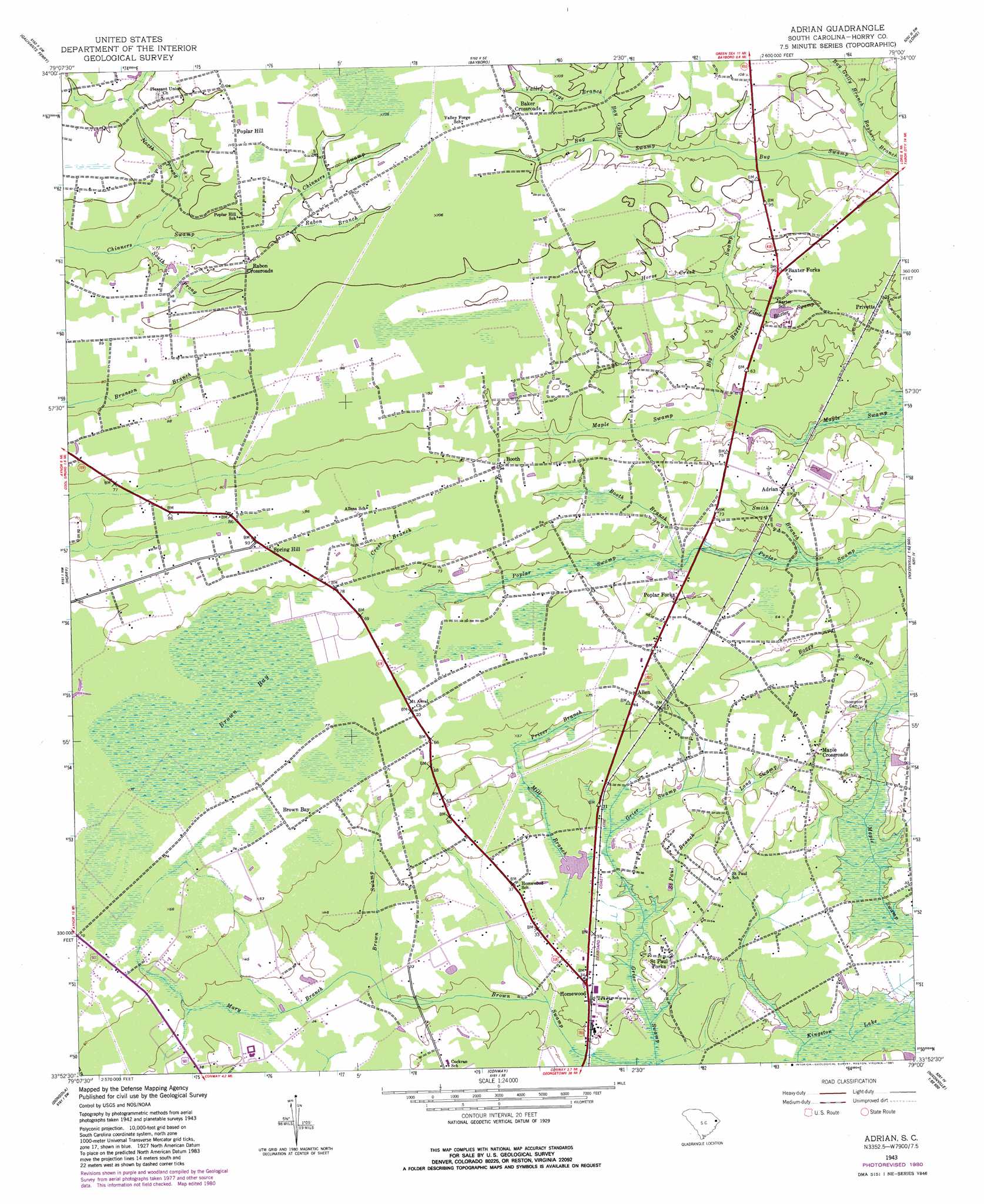
USGS Topo Quad 33079h1 - 1:24,000 scale
| Topo Map Name: | Adrian |
| USGS Topo Quad ID: | 33079h1 |
| Print Size: | ca. 21 1/4" wide x 27" high |
| Southeast Coordinates: | 33.875° N latitude / 79° W longitude |
| Map Center Coordinates: | 33.9375° N latitude / 79.0625° W longitude |
| U.S. State: | SC |
| Filename: | o33079h1.jpg |
| Download Map JPG Image: | Adrian topo map 1:24,000 scale |
| Map Type: | Topographic |
| Topo Series: | 7.5´ |
| Map Scale: | 1:24,000 |
| Source of Map Images: | United States Geological Survey (USGS) |
| Alternate Map Versions: |
Adrian SC 1943, updated 1962 Download PDF Buy paper map Adrian SC 1943, updated 1981 Download PDF Buy paper map Adrian SC 2011 Download PDF Buy paper map Adrian SC 2014 Download PDF Buy paper map |
1:24,000 Topo Quads surrounding Adrian
Mullins |
Nichols |
Duford |
Tabor City West |
Tabor City East |
Centenary |
Galivants Ferry |
Bayboro |
Loris |
Goretown |
Britton Neck |
Horry |
Adrian |
Shell |
Hammond |
Snow Island |
Dongola |
Conway |
Nixonville |
Hand |
Outland |
Yauhannah |
Bucksville |
Myrtle Beach |
Ocean Forest |
> Back to 33079e1 at 1:100,000 scale
> Back to 33078a1 at 1:250,000 scale
> Back to U.S. Topo Maps home
Adrian topo map: Gazetteer
Adrian: Dams
South Carolina Noname 26002 D-3622 Dam elevation 10m 32′Adrian: Populated Places
Adrian elevation 20m 65′Allen elevation 18m 59′
Baker Crossroads elevation 32m 104′
Baxter Forks elevation 27m 88′
Booth elevation 26m 85′
Brown Bay elevation 19m 62′
Cebu (historical) elevation 21m 68′
Homewood elevation 7m 22′
Joy (historical) elevation 25m 82′
Maple Crossroads elevation 14m 45′
Polecat Bay (historical) elevation 26m 85′
Poplar Forks elevation 18m 59′
Poplar Hill elevation 31m 101′
Privetts elevation 23m 75′
Rabon Crossroads elevation 31m 101′
Saint Paul Forks elevation 7m 22′
Spring Hill elevation 25m 82′
Adrian: Reservoirs
Hoffman Pond Dam elevation 10m 32′Adrian: Streams
Bay Gully Branch elevation 21m 68′Big Baxter Swamp elevation 16m 52′
Boggy Swamp elevation 6m 19′
Booth Branch elevation 14m 45′
Broadway Branch elevation 24m 78′
Cross Branch elevation 24m 78′
Horse Creek elevation 22m 72′
Little Baxter Swamp elevation 17m 55′
Long Swamp elevation 11m 36′
Mary Branch elevation 6m 19′
Mill Branch elevation 10m 32′
North Prong Chinners Swamp elevation 24m 78′
Priver Branch elevation 17m 55′
Rabon Branch elevation 28m 91′
Saint Paul Branch elevation 6m 19′
Smith Branch elevation 11m 36′
South Prong Chinners Swamp elevation 24m 78′
Adrian: Swamps
Brown Bay elevation 22m 72′Adrian digital topo map on disk
Buy this Adrian topo map showing relief, roads, GPS coordinates and other geographical features, as a high-resolution digital map file on DVD:
South Carolina, Western North Carolina & Northeastern Georgia
Buy digital topo maps: South Carolina, Western North Carolina & Northeastern Georgia