Branchville South Topo Map South Carolina
To zoom in, hover over the map of Branchville South
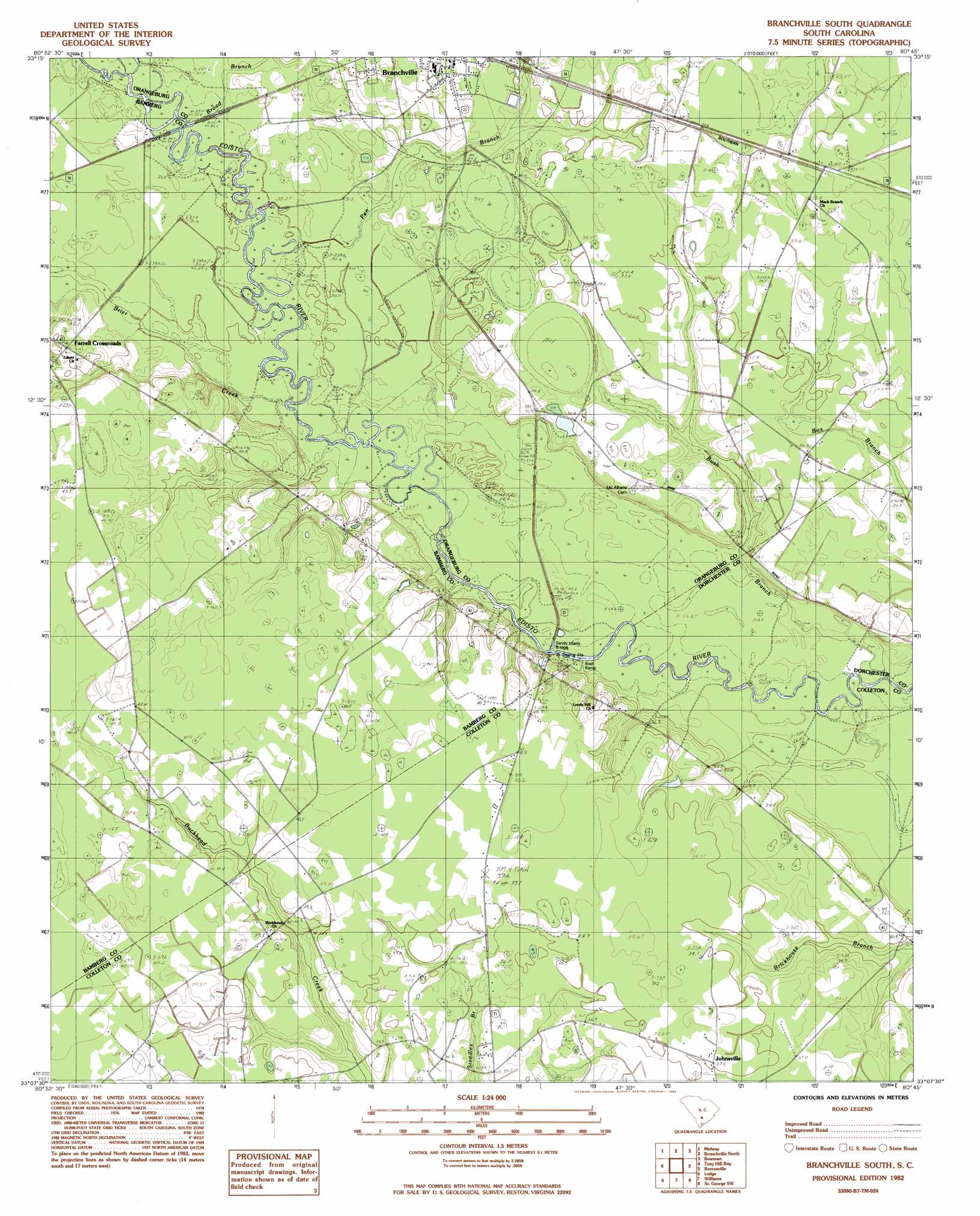
USGS Topo Quad 33080b7 - 1:24,000 scale
| Topo Map Name: | Branchville South |
| USGS Topo Quad ID: | 33080b7 |
| Print Size: | ca. 21 1/4" wide x 27" high |
| Southeast Coordinates: | 33.125° N latitude / 80.75° W longitude |
| Map Center Coordinates: | 33.1875° N latitude / 80.8125° W longitude |
| U.S. State: | SC |
| Filename: | o33080b7.jpg |
| Download Map JPG Image: | Branchville South topo map 1:24,000 scale |
| Map Type: | Topographic |
| Topo Series: | 7.5´ |
| Map Scale: | 1:24,000 |
| Source of Map Images: | United States Geological Survey (USGS) |
| Alternate Map Versions: |
Branchville South SC 1982, updated 1983 Download PDF Buy paper map Branchville South SC 2011 Download PDF Buy paper map Branchville South SC 2014 Download PDF Buy paper map |
1:24,000 Topo Quads surrounding Branchville South
Norway East |
Cordova |
Orangeburg South |
Indian Camp Branch |
Felderville |
Bamberg |
Midway |
Branchville North |
Bowman |
Wadboo Swamp |
Clear Pond |
Tony Hill Bay |
Branchville South |
Reevesville |
Saint George |
Ehrhardt |
Lodge |
Williams |
Saint George Sw |
Canadys |
Crocketville |
Islandton |
Sniders Crossroads |
Walterboro |
Round O |
> Back to 33080a1 at 1:100,000 scale
> Back to 33080a1 at 1:250,000 scale
> Back to U.S. Topo Maps home
Branchville South topo map: Gazetteer
Branchville South: Bridges
Fitts Bridge elevation 30m 98′Sandy Island Bridge elevation 33m 108′
Branchville South: Dams
Dukes Pond Dam D-3779 elevation 29m 95′Branchville South: Populated Places
Farrell Crossroads elevation 37m 121′Fifty Eight (historical) elevation 42m 137′
Johnsville elevation 37m 121′
Whetstone Crossroads elevation 36m 118′
Branchville South: Streams
Betty Branch elevation 29m 95′Brier Creek elevation 27m 88′
Bush Branch elevation 24m 78′
Pen Branch elevation 28m 91′
Branchville South digital topo map on disk
Buy this Branchville South topo map showing relief, roads, GPS coordinates and other geographical features, as a high-resolution digital map file on DVD:
South Carolina, Western North Carolina & Northeastern Georgia
Buy digital topo maps: South Carolina, Western North Carolina & Northeastern Georgia