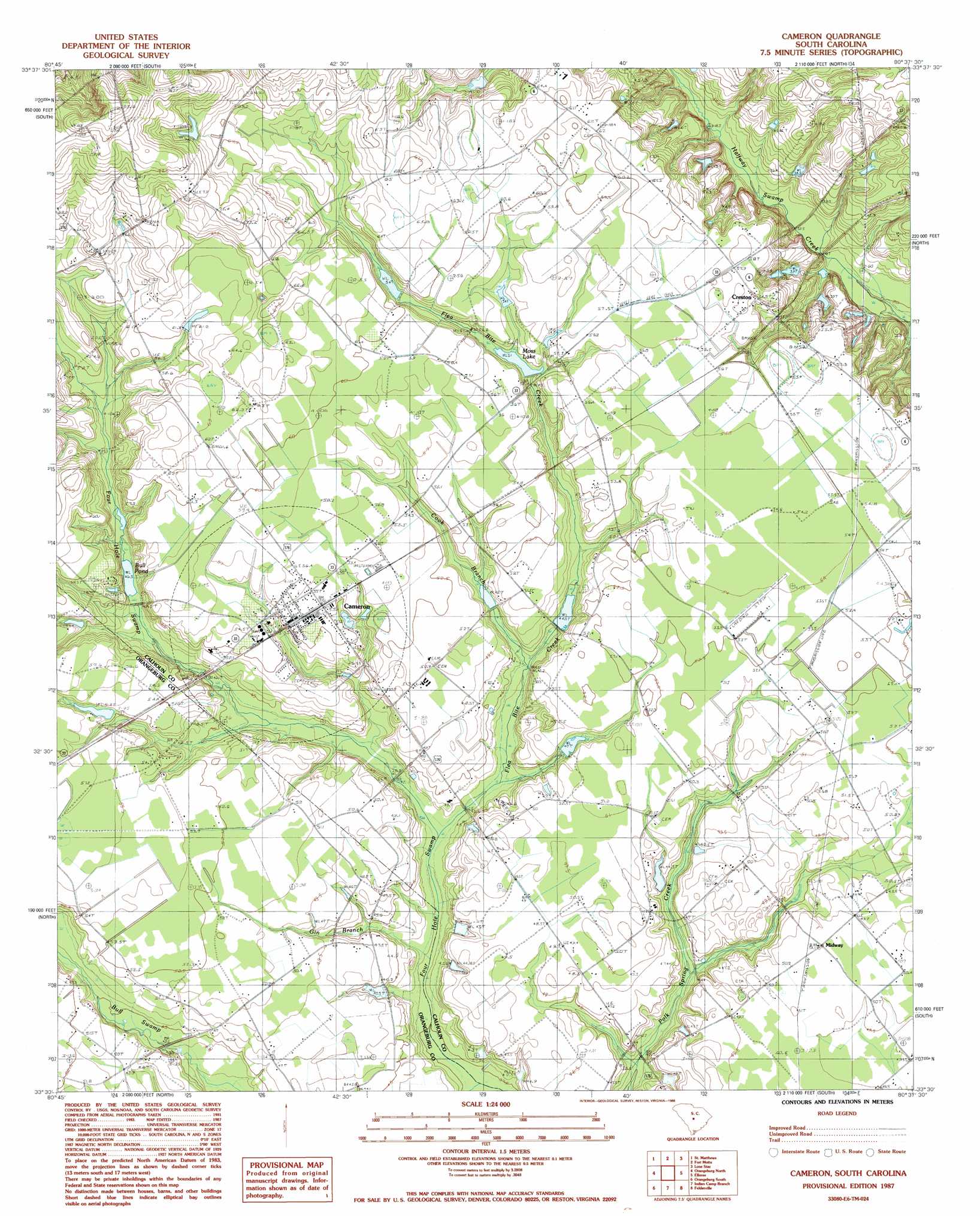
Cameron Topo Map South Carolina
To zoom in, hover over the map of Cameron
USGS Topo Quad 33080e6 - 1:24,000 scale
| Topo Map Name: | Cameron |
| USGS Topo Quad ID: | 33080e6 |
| Print Size: | ca. 21 1/4" wide x 27" high |
| Southeast Coordinates: | 33.5° N latitude / 80.625° W longitude |
| Map Center Coordinates: | 33.5625° N latitude / 80.6875° W longitude |
| U.S. State: | SC |
| Filename: | o33080e6.jpg |
| Download Map JPG Image: | Cameron topo map 1:24,000 scale |
| Map Type: | Topographic |
| Topo Series: | 7.5´ |
| Map Scale: | 1:24,000 |
| Source of Map Images: | United States Geological Survey (USGS) |
| Alternate Map Versions: |
Cameron SC 1987, updated 1988 Download PDF Buy paper map Cameron SC 2011 Download PDF Buy paper map Cameron SC 2014 Download PDF Buy paper map |
1:24,000 Topo Quads surrounding Cameron
Saylors Lake |
Gadsden |
Wateree |
Poinsett State Park |
Privateer |
Staley Crossroads |
Saint Mathews |
Fort Motte |
Lone Star |
Pinewood |
Wolfton |
Orangeburg North |
Cameron |
Elloree |
Saint Paul |
Cordova |
Orangeburg South |
Indian Camp Branch |
Felderville |
Vance |
Midway |
Branchville North |
Bowman |
Wadboo Swamp |
Holly Hill |
> Back to 33080e1 at 1:100,000 scale
> Back to 33080a1 at 1:250,000 scale
> Back to U.S. Topo Maps home
Cameron topo map: Gazetteer
Cameron: Airports
McNeil Airport elevation 52m 170′Cameron: Dams
Edwards Pond Dam D-2688 elevation 31m 101′Harmond Pond Dam D-2664 elevation 46m 150′
Jessie Rast Pond Dam D-2687 elevation 43m 141′
Pricketts Pond Dam D-3724 elevation 53m 173′
South Carolina Noname 09025 D-2640 Dam elevation 55m 180′
South Carolina Noname 09026 D-2641 Dam elevation 52m 170′
South Carolina Noname 09027 D-2920 Dam elevation 43m 141′
South Carolina Noname 09040 D-2921 Dam elevation 48m 157′
South Carolina Noname 09043 D-2663 Dam elevation 49m 160′
South Carolina Noname 38021 D-3742 Dam elevation 44m 144′
Whetstone Pond Dam D-2686 elevation 82m 269′
Cameron: Populated Places
Cameron elevation 54m 177′Creston elevation 55m 180′
Midway elevation 50m 164′
Cameron: Post Offices
Cameron Post Office elevation 54m 177′Cameron: Reservoirs
Bull Pond elevation 48m 157′Bull Pond elevation 53m 173′
Edwards Pond elevation 31m 101′
Harmond Pond elevation 46m 150′
Houch Pond elevation 49m 160′
Jessie Rast Pond elevation 43m 141′
Moss Lake elevation 51m 167′
Shuller Pond elevation 44m 144′
T C Moss Pond elevation 55m 180′
Whetstone Pond elevation 82m 269′
Cameron: Streams
Bay Branch elevation 43m 141′Bull Swamp elevation 35m 114′
Cook Branch elevation 43m 141′
Flea Bite Creek elevation 40m 131′
Gin Branch elevation 38m 124′
Cameron digital topo map on disk
Buy this Cameron topo map showing relief, roads, GPS coordinates and other geographical features, as a high-resolution digital map file on DVD:
South Carolina, Western North Carolina & Northeastern Georgia
Buy digital topo maps: South Carolina, Western North Carolina & Northeastern Georgia