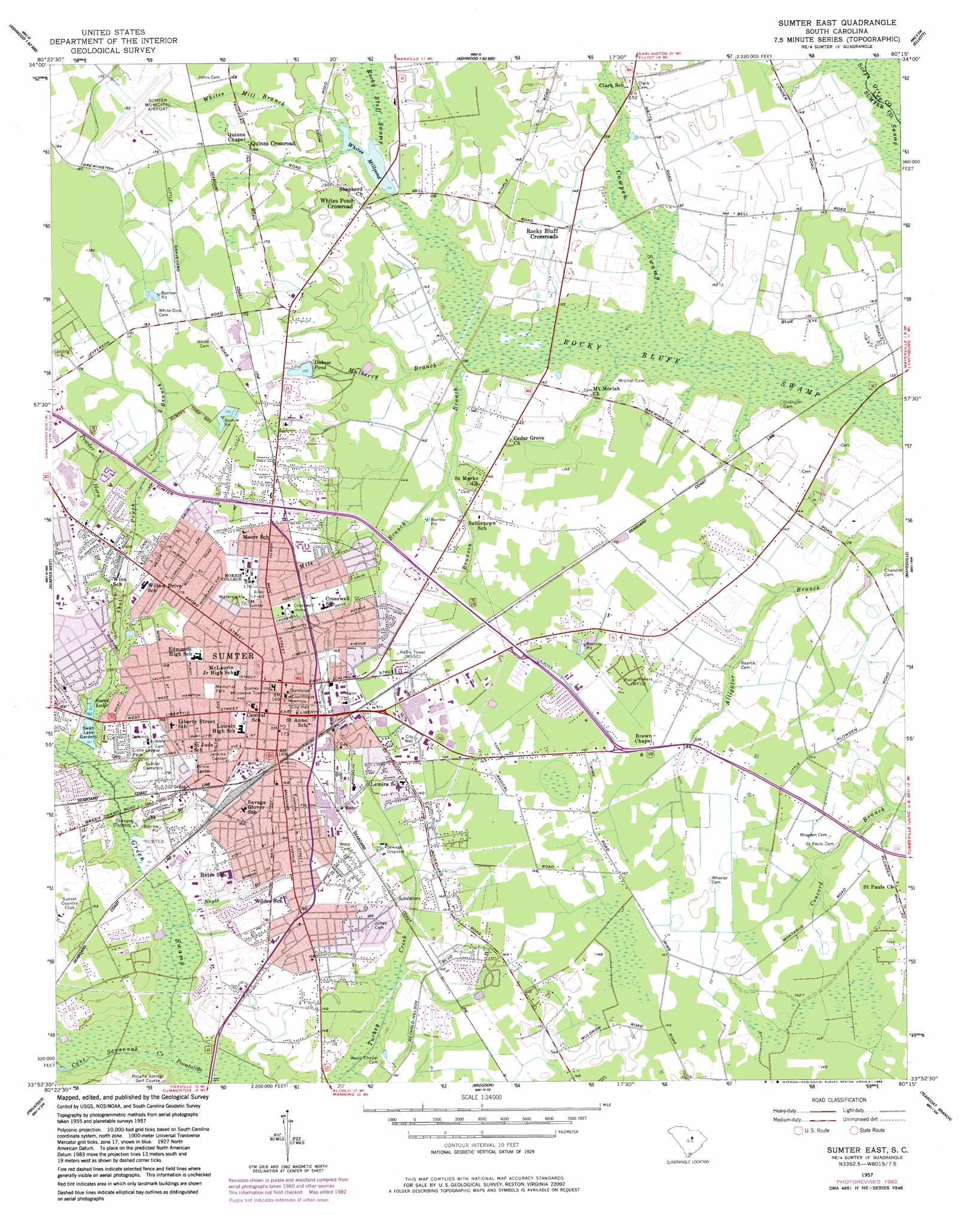
Sumter East Topo Map South Carolina
To zoom in, hover over the map of Sumter East
USGS Topo Quad 33080h3 - 1:24,000 scale
| Topo Map Name: | Sumter East |
| USGS Topo Quad ID: | 33080h3 |
| Print Size: | ca. 21 1/4" wide x 27" high |
| Southeast Coordinates: | 33.875° N latitude / 80.25° W longitude |
| Map Center Coordinates: | 33.9375° N latitude / 80.3125° W longitude |
| U.S. State: | SC |
| Filename: | o33080h3.jpg |
| Download Map JPG Image: | Sumter East topo map 1:24,000 scale |
| Map Type: | Topographic |
| Topo Series: | 7.5´ |
| Map Scale: | 1:24,000 |
| Source of Map Images: | United States Geological Survey (USGS) |
| Alternate Map Versions: |
Sumter East SC 1957, updated 1958 Download PDF Buy paper map Sumter East SC 1957, updated 1958 Download PDF Buy paper map Sumter East SC 1957, updated 1983 Download PDF Buy paper map Sumter East SC 2011 Download PDF Buy paper map Sumter East SC 2014 Download PDF Buy paper map |
1:24,000 Topo Quads surrounding Sumter East
Camden South |
Spring Hill |
Bishopville West |
Bishopville East |
Lamar |
Rembert |
Dalzell |
Oswego |
Elliott |
Lynchburg |
Wedgefield |
Sumter West |
Sumter East |
Mayesville |
Turbeville |
Poinsett State Park |
Privateer |
Brogdon |
Tearcoat Branch |
Sardinia |
Lone Star |
Pinewood |
Paxville |
Manning |
Foreston |
> Back to 33080e1 at 1:100,000 scale
> Back to 33080a1 at 1:250,000 scale
> Back to U.S. Topo Maps home
Sumter East topo map: Gazetteer
Sumter East: Airports
Sumter Municipal Airport elevation 54m 177′Sumter East: Dams
Dubose Pond Dam D-1442 elevation 49m 160′Swan Lake Dam D-1447 elevation 43m 141′
Whites Millpond Dam D-1988 elevation 43m 141′
Sumter East: Parks
Birnie Center elevation 49m 160′Crosswell Drive Park elevation 47m 154′
Eastwood Park elevation 42m 137′
Iris Gardens elevation 46m 150′
Jenkins Center elevation 51m 167′
Julia Lester Dillon Park elevation 52m 170′
Little League Park elevation 48m 157′
Riley Field elevation 52m 170′
Sumter Historic District elevation 52m 170′
Swan Lake Gardens elevation 45m 147′
Sumter East: Populated Places
Archdale elevation 52m 170′Brady Heights elevation 48m 157′
Burns Down elevation 52m 170′
Carolina Gardens elevation 52m 170′
Club Forest elevation 51m 167′
Concord Estates elevation 43m 141′
East Sumter elevation 44m 144′
Flowers Heights elevation 49m 160′
Folsom Park elevation 52m 170′
Forest Heights elevation 45m 147′
Forest Hills elevation 42m 137′
Garris Park elevation 49m 160′
Gatewood Park elevation 52m 170′
Geddie Gardens elevation 43m 141′
Golden Acre Mobile Home Park elevation 44m 144′
Green Acres elevation 45m 147′
Greenwood elevation 43m 141′
Guignard Park elevation 42m 137′
Guignard Park East elevation 49m 160′
Huntington elevation 48m 157′
Iris Heights elevation 49m 160′
Ivey Hall elevation 47m 154′
Jefferson Park elevation 54m 177′
Kingman Heights elevation 50m 164′
Lafayette Heights elevation 50m 164′
Lazy Acres Estates elevation 43m 141′
Leawood elevation 43m 141′
Marigold Heights elevation 48m 157′
Martin Subdivision elevation 43m 141′
Midfield elevation 45m 147′
Midland Acres elevation 44m 144′
Moses Heights elevation 46m 150′
Mulberry elevation 45m 147′
Oaklawn elevation 54m 177′
Pine Acres elevation 43m 141′
Pinedale elevation 48m 157′
Pinehurst elevation 51m 167′
Quinns Crossroad elevation 49m 160′
Ranchland Ranchettes elevation 43m 141′
Richwood elevation 45m 147′
Rocky Bluff Crossroads elevation 43m 141′
Runnymeade elevation 52m 170′
Shannontown elevation 49m 160′
Shaws Crossroads elevation 43m 141′
Sherwood Forest elevation 44m 144′
South Sumter elevation 49m 160′
Summers Homes elevation 53m 173′
Sumter elevation 52m 170′
Tiller Circle elevation 44m 144′
Walnut Hills elevation 54m 177′
Wen-le elevation 44m 144′
Whites Pond Crossroad elevation 43m 141′
Sumter East: Post Offices
Sumter Post Office elevation 52m 170′Sumter East: Reservoirs
Dubose Pond elevation 49m 160′Dubose Pond elevation 51m 167′
Swan Lake elevation 43m 141′
Swan Lake elevation 43m 141′
Whites Millpond elevation 43m 141′
Sumter East: Streams
Brunson Branch elevation 39m 127′Cane Savannah Creek elevation 35m 114′
Cowpen Swamp elevation 35m 114′
Green Swamp elevation 35m 114′
Mile Branch elevation 42m 137′
Mulberry Branch elevation 38m 124′
Noyts Branch elevation 38m 124′
Powder Horn Branch elevation 45m 147′
Shot Pouch Branch elevation 40m 131′
Sooks Branch elevation 38m 124′
Whites Mill Branch elevation 43m 141′
Sumter East digital topo map on disk
Buy this Sumter East topo map showing relief, roads, GPS coordinates and other geographical features, as a high-resolution digital map file on DVD:
South Carolina, Western North Carolina & Northeastern Georgia
Buy digital topo maps: South Carolina, Western North Carolina & Northeastern Georgia