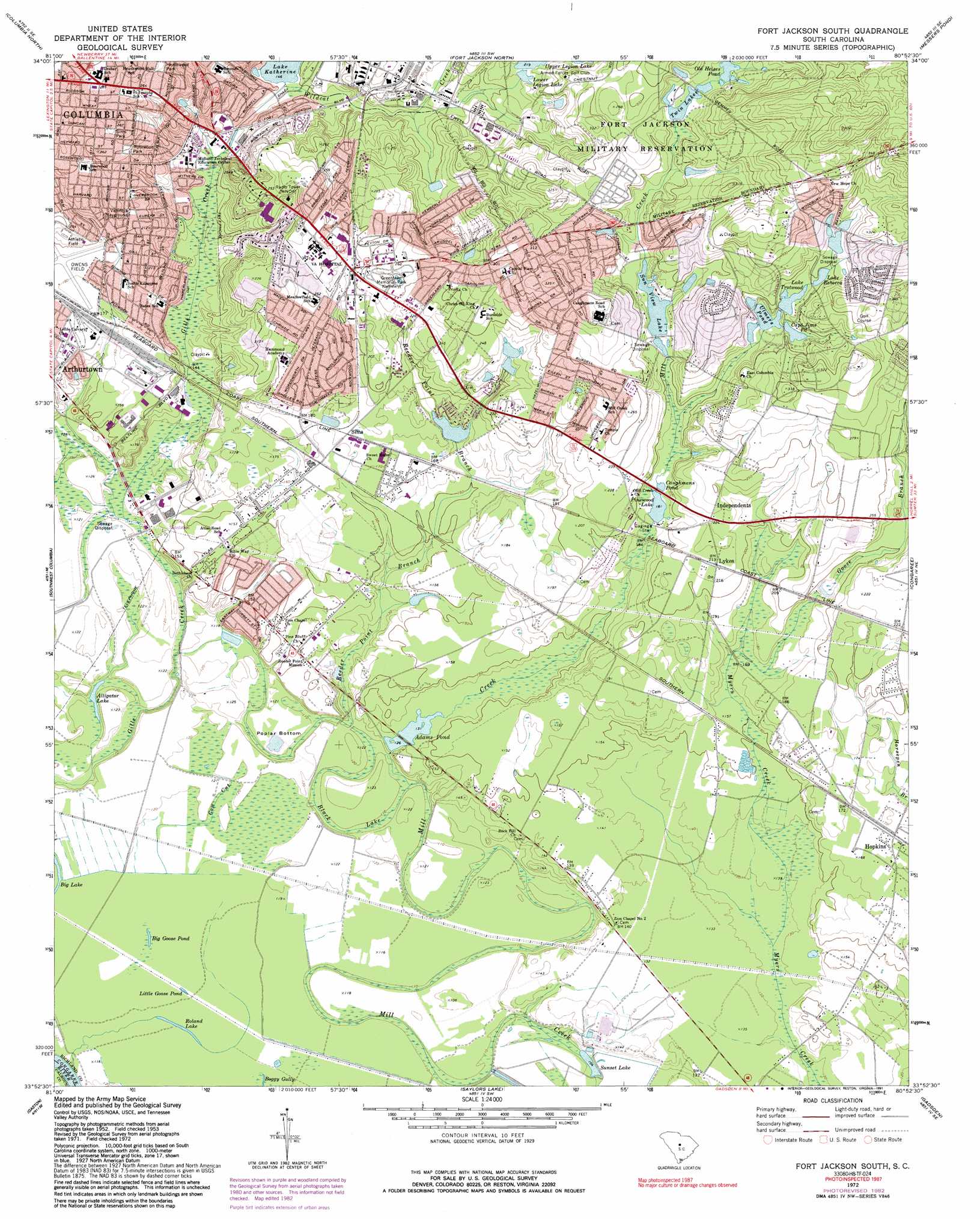
Fort Jackson South Topo Map South Carolina
To zoom in, hover over the map of Fort Jackson South
USGS Topo Quad 33080h8 - 1:24,000 scale
| Topo Map Name: | Fort Jackson South |
| USGS Topo Quad ID: | 33080h8 |
| Print Size: | ca. 21 1/4" wide x 27" high |
| Southeast Coordinates: | 33.875° N latitude / 80.875° W longitude |
| Map Center Coordinates: | 33.9375° N latitude / 80.9375° W longitude |
| U.S. State: | SC |
| Filename: | o33080h8.jpg |
| Download Map JPG Image: | Fort Jackson South topo map 1:24,000 scale |
| Map Type: | Topographic |
| Topo Series: | 7.5´ |
| Map Scale: | 1:24,000 |
| Source of Map Images: | United States Geological Survey (USGS) |
| Alternate Map Versions: |
Fort Jackson South SC 1953, updated 1957 Download PDF Buy paper map Fort Jackson South SC 1972, updated 1973 Download PDF Buy paper map Fort Jackson South SC 1972, updated 1983 Download PDF Buy paper map Fort Jackson South SC 1972, updated 1991 Download PDF Buy paper map Fort Jackson South SC 2011 Download PDF Buy paper map Fort Jackson South SC 2014 Download PDF Buy paper map |
1:24,000 Topo Quads surrounding Fort Jackson South
Richtex |
Irmo Ne |
Blythewood |
Elgin |
Lugoff |
Irmo |
Columbia North |
Fort Jackson North |
Messers Pond |
Leesburg |
Lexington |
Southwest Columbia |
Fort Jackson South |
Congaree |
Eastover |
Pelion East |
Gaston |
Saylors Lake |
Gadsden |
Wateree |
Pond Branch |
Swansea |
Staley Crossroads |
Saint Mathews |
Fort Motte |
> Back to 33080e1 at 1:100,000 scale
> Back to 33080a1 at 1:250,000 scale
> Back to U.S. Topo Maps home
Fort Jackson South topo map: Gazetteer
Fort Jackson South: Airports
Columbia Owens Downtown Airport elevation 53m 173′Fort Jackson South: Bends
Poplar Bottom elevation 35m 114′Fort Jackson South: Dams
Burnsides Pond D-0576 Dam elevation 48m 157′Lake Trotwood Dam elevation 71m 232′
Lower Twin Lake Dam - Fort Jackson elevation 72m 236′
Pinewood Lake D-0580 Dam elevation 55m 180′
South Carolina Noname 40012 D-0577 Dam elevation 40m 131′
Ulmers Pond D-0581 Dam elevation 67m 219′
Upper Legion Lake Dam - Fort Jackson elevation 66m 216′
Fort Jackson South: Guts
Black Lake elevation 33m 108′Cow Cut elevation 36m 118′
Fort Jackson South: Lakes
Alligator Lake elevation 36m 118′Big Goose Pond elevation 35m 114′
Little Goose Pond elevation 34m 111′
Roland Lake elevation 34m 111′
Fort Jackson South: Parks
Bates Park elevation 63m 206′Bluff Road Park elevation 38m 124′
Caughman Road Park elevation 80m 262′
Hampton Memorial Park elevation 68m 223′
Heathwood Park elevation 80m 262′
Rosewood Park elevation 77m 252′
Sims Park elevation 82m 269′
Valencia Playground elevation 63m 206′
Woodland Park elevation 73m 239′
Fort Jackson South: Populated Places
Bendemeer elevation 82m 269′Berkeley Forest elevation 88m 288′
Bluff Estates elevation 45m 147′
Brandon Acres elevation 84m 275′
Brandon Hills elevation 69m 226′
Burnside East elevation 62m 203′
Capitol View elevation 94m 308′
Charlestowne elevation 83m 272′
Childs elevation 51m 167′
Dominion Hills elevation 79m 259′
Eastmont elevation 70m 229′
Eastway Park elevation 47m 154′
Galaxy elevation 85m 278′
Gordon Springs elevation 78m 255′
Hampton Ridge elevation 70m 229′
Hampton Trace elevation 60m 196′
Hazelwood Acres elevation 81m 265′
Heathwood elevation 83m 272′
Heritage Woods elevation 61m 200′
Hopkins elevation 50m 164′
Independents elevation 69m 226′
Knollwood elevation 65m 213′
Lee Hills elevation 100m 328′
Lykes elevation 65m 213′
Meadowfield elevation 62m 203′
Mill Creek Estates elevation 59m 193′
Millwood elevation 52m 170′
Mountain Brook elevation 73m 239′
Padgett Acres elevation 93m 305′
Pennington Acres elevation 82m 269′
Pine Lake elevation 91m 298′
Quail Creek elevation 86m 282′
Quail Hills elevation 89m 291′
Rosewood elevation 79m 259′
Saint Marks Wood elevation 77m 252′
Sims elevation 53m 173′
Starlite elevation 46m 150′
Strathaven Forest elevation 75m 246′
Valencia Heights elevation 62m 203′
Village Bond elevation 96m 314′
Washington Park elevation 46m 150′
Woodhill Estates elevation 61m 200′
Yorkshire elevation 67m 219′
Fort Jackson South: Reservoirs
Adams Pond elevation 40m 131′Captain Jims Pond elevation 71m 232′
Caughmans Pond elevation 57m 187′
Caughmans Pond elevation 55m 180′
Griffin Lake elevation 71m 232′
Lake Katherine elevation 41m 134′
Lake Rebecca elevation 73m 239′
Lake Trotwood elevation 71m 232′
Lower Legion Lake elevation 63m 206′
Lower Twin Lake elevation 72m 236′
Old Heises Pond elevation 77m 252′
Pinewood Lake elevation 55m 180′
Sun View Lake elevation 65m 213′
Sunset Lake elevation 34m 111′
Twin Lakes elevation 77m 252′
Ulmers Lake elevation 68m 223′
Ulmers Pond elevation 67m 219′
Upper Legion Lake elevation 63m 206′
Upper Legion Lake elevation 66m 216′
Washington Lake elevation 65m 213′
Fort Jackson South: Streams
Goose Branch elevation 48m 157′Reeder Point Branch elevation 33m 108′
Wildcat Creek elevation 44m 144′
Fort Jackson South digital topo map on disk
Buy this Fort Jackson South topo map showing relief, roads, GPS coordinates and other geographical features, as a high-resolution digital map file on DVD:
South Carolina, Western North Carolina & Northeastern Georgia
Buy digital topo maps: South Carolina, Western North Carolina & Northeastern Georgia