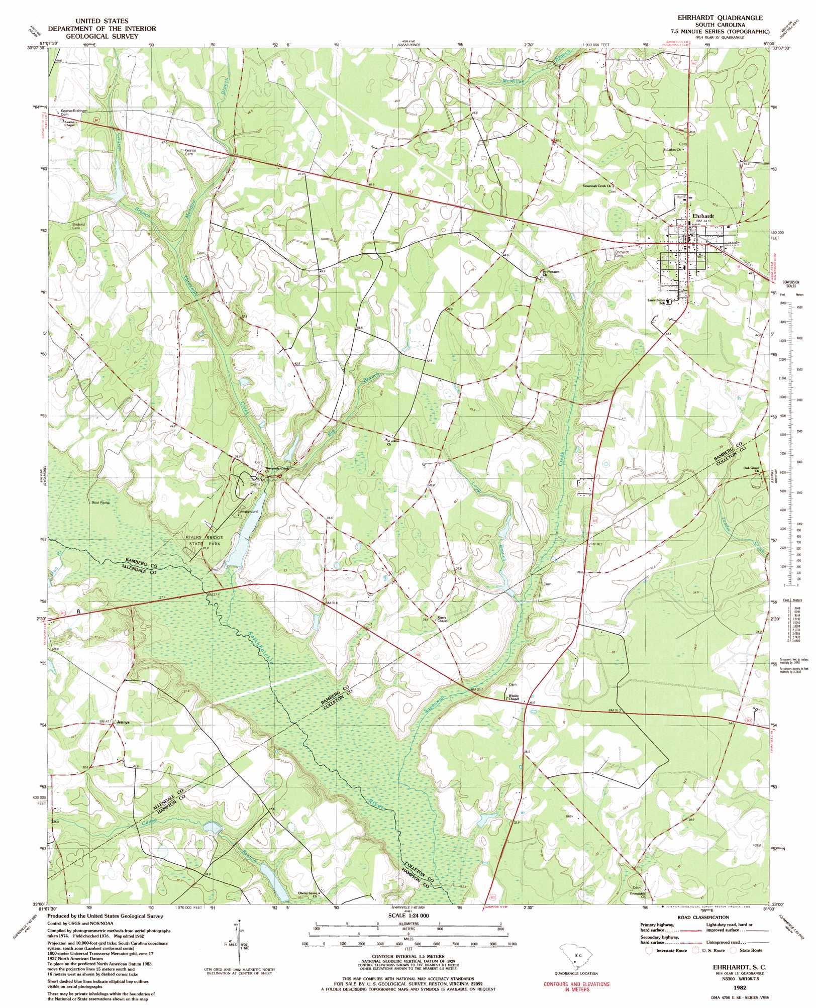
Ehrhardt Topo Map South Carolina
To zoom in, hover over the map of Ehrhardt
USGS Topo Quad 33081a1 - 1:24,000 scale
| Topo Map Name: | Ehrhardt |
| USGS Topo Quad ID: | 33081a1 |
| Print Size: | ca. 21 1/4" wide x 27" high |
| Southeast Coordinates: | 33° N latitude / 81° W longitude |
| Map Center Coordinates: | 33.0625° N latitude / 81.0625° W longitude |
| U.S. State: | SC |
| Filename: | o33081a1.jpg |
| Download Map JPG Image: | Ehrhardt topo map 1:24,000 scale |
| Map Type: | Topographic |
| Topo Series: | 7.5´ |
| Map Scale: | 1:24,000 |
| Source of Map Images: | United States Geological Survey (USGS) |
| Alternate Map Versions: |
Ehrhardt SC 1982, updated 1983 Download PDF Buy paper map Ehrhardt SC 2011 Download PDF Buy paper map Ehrhardt SC 2014 Download PDF Buy paper map |
1:24,000 Topo Quads surrounding Ehrhardt
Blackville |
Denmark |
Bamberg |
Midway |
Branchville North |
Barnwell |
Olar |
Clear Pond |
Tony Hill Bay |
Branchville South |
Allendale |
Sycamore |
Ehrhardt |
Lodge |
Williams |
Barton |
Fairfax |
Crocketville |
Islandton |
Sniders Crossroads |
Solomons Crossroads |
Gifford |
Hampton |
Cummings |
Black Creek |
> Back to 33081a1 at 1:100,000 scale
> Back to 33080a1 at 1:250,000 scale
> Back to U.S. Topo Maps home
Ehrhardt topo map: Gazetteer
Ehrhardt: Airports
Broxton Bridge Plantation Airport elevation 27m 88′Ehrhardt Airport elevation 44m 144′
Ehrhardt: Bridges
Rivers Bridge elevation 26m 85′Ehrhardt: Dams
Brants Pond Dam D-2819 elevation 41m 134′Hiers Pond Dam D-2822 elevation 26m 85′
Lake Hi-Ki Pen Dam D-2817 elevation 35m 114′
South Carolina Noname 25018 D-2596 Dam elevation 29m 95′
Ehrhardt: Parks
Rivers Bridge State Park elevation 34m 111′Ehrhardt: Populated Places
Ehrhardt elevation 44m 144′Jennys elevation 41m 134′
Ehrhardt: Post Offices
Ehrhardt Post Office elevation 44m 144′Ehrhardt: Reservoirs
Copes Mill Pond elevation 26m 85′Jenny Pond elevation 29m 95′
Ehrhardt: Streams
Big Branch elevation 28m 91′Church Branch elevation 36m 118′
Hog Branch elevation 26m 85′
Long Branch elevation 27m 88′
Meadow Branch elevation 36m 118′
Savannah Creek elevation 23m 75′
Threemile Branch elevation 25m 82′
Ehrhardt digital topo map on disk
Buy this Ehrhardt topo map showing relief, roads, GPS coordinates and other geographical features, as a high-resolution digital map file on DVD:
South Carolina, Western North Carolina & Northeastern Georgia
Buy digital topo maps: South Carolina, Western North Carolina & Northeastern Georgia