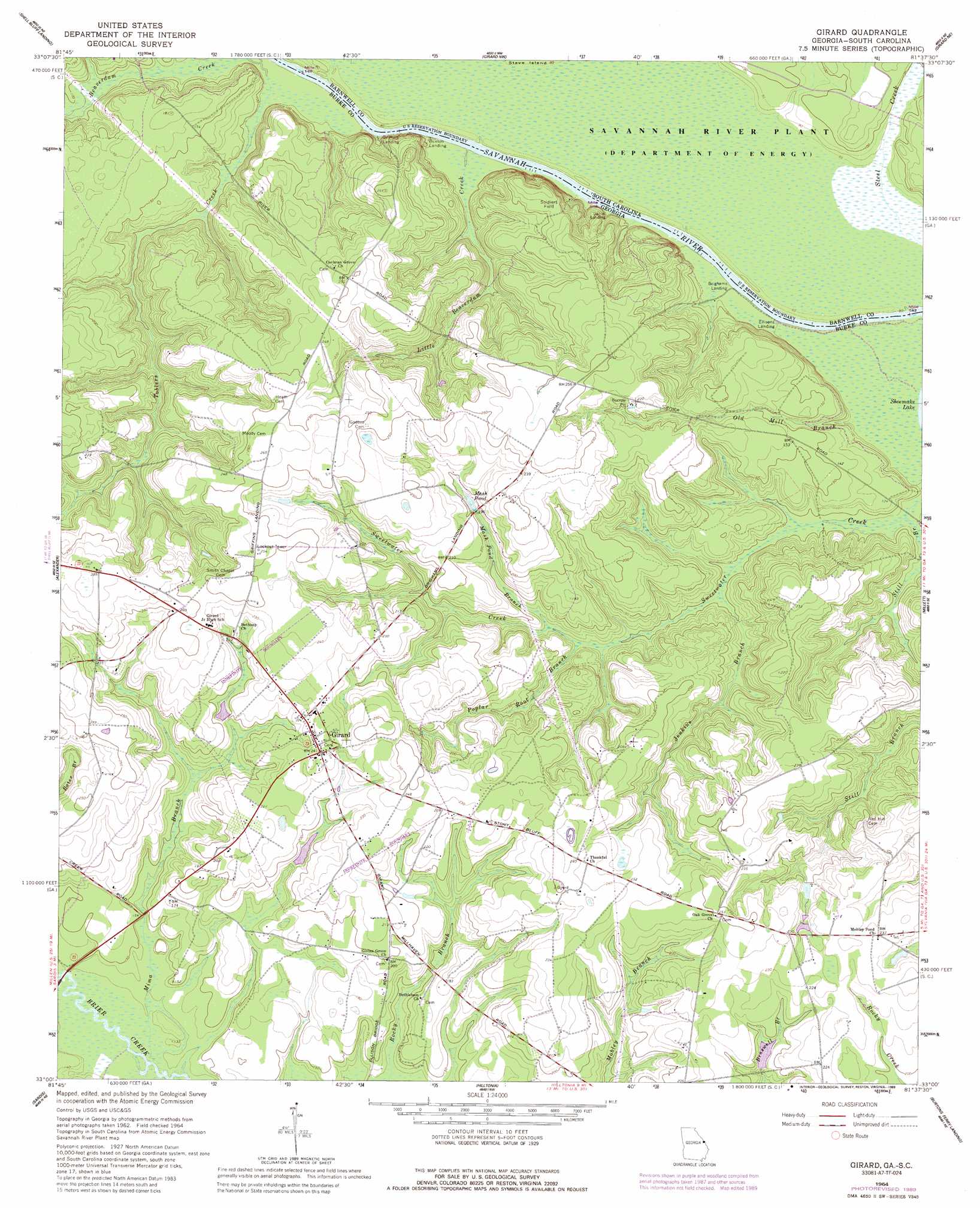
Girard Topo Map Georgia
To zoom in, hover over the map of Girard
USGS Topo Quad 33081a6 - 1:24,000 scale
| Topo Map Name: | Girard |
| USGS Topo Quad ID: | 33081a6 |
| Print Size: | ca. 21 1/4" wide x 27" high |
| Southeast Coordinates: | 33° N latitude / 81.625° W longitude |
| Map Center Coordinates: | 33.0625° N latitude / 81.6875° W longitude |
| U.S. States: | GA, SC |
| Filename: | o33081a6.jpg |
| Download Map JPG Image: | Girard topo map 1:24,000 scale |
| Map Type: | Topographic |
| Topo Series: | 7.5´ |
| Map Scale: | 1:24,000 |
| Source of Map Images: | United States Geological Survey (USGS) |
| Alternate Map Versions: |
Girard GA 1964, updated 1965 Download PDF Buy paper map Girard GA 1964, updated 1976 Download PDF Buy paper map Girard GA 1964, updated 1989 Download PDF Buy paper map Girard GA 2011 Download PDF Buy paper map Girard GA 2014 Download PDF Buy paper map |
| FStopo: | US Forest Service topo Girard is available: Download FStopo PDF Download FStopo TIF |
1:24,000 Topo Quads surrounding Girard
Mechanic Hill |
Jackson |
New Ellenton Sw |
New Ellenton Se |
Long Branch |
Mcbean |
Shell Bluff Landing |
Girard Nw |
Girard Ne |
Snelling |
Idlewood |
Alexander |
Girard |
Millett |
Martin |
Perkins |
Sardis |
Hilltonia |
Burtons Ferry Landing |
Bull Pond |
Millen |
Bay Branch |
Sylvania North |
Jacksonboro Bridge |
Brier Creek Landing |
> Back to 33081a1 at 1:100,000 scale
> Back to 33080a1 at 1:250,000 scale
> Back to U.S. Topo Maps home
Girard topo map: Gazetteer
Girard: Populated Places
Girard elevation 73m 239′Girard: Reservoirs
Mash Pond elevation 57m 187′Girard: Streams
Jenkins Branch elevation 30m 98′Little Beaverdam Creek elevation 24m 78′
Mash Pond Branch elevation 34m 111′
Mima Branch elevation 38m 124′
Old Mill Branch elevation 24m 78′
Pen Branch elevation 25m 82′
Poplar Root Branch elevation 32m 104′
Still Branch elevation 25m 82′
Toblers Creek elevation 25m 82′
Girard digital topo map on disk
Buy this Girard topo map showing relief, roads, GPS coordinates and other geographical features, as a high-resolution digital map file on DVD:
South Carolina, Western North Carolina & Northeastern Georgia
Buy digital topo maps: South Carolina, Western North Carolina & Northeastern Georgia