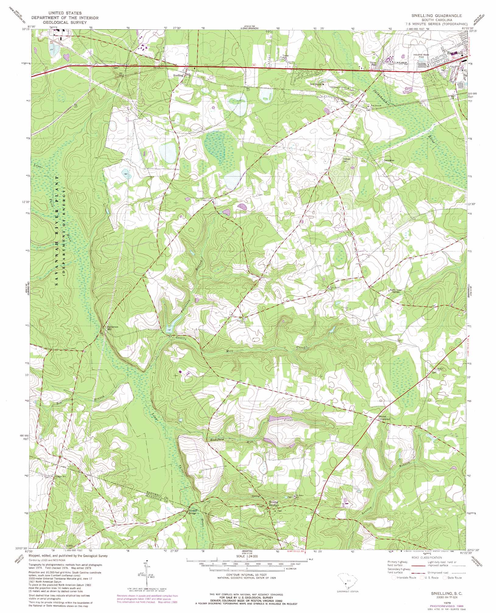
Snelling Topo Map South Carolina
To zoom in, hover over the map of Snelling
USGS Topo Quad 33081b4 - 1:24,000 scale
| Topo Map Name: | Snelling |
| USGS Topo Quad ID: | 33081b4 |
| Print Size: | ca. 21 1/4" wide x 27" high |
| Southeast Coordinates: | 33.125° N latitude / 81.375° W longitude |
| Map Center Coordinates: | 33.1875° N latitude / 81.4375° W longitude |
| U.S. State: | SC |
| Filename: | o33081b4.jpg |
| Download Map JPG Image: | Snelling topo map 1:24,000 scale |
| Map Type: | Topographic |
| Topo Series: | 7.5´ |
| Map Scale: | 1:24,000 |
| Source of Map Images: | United States Geological Survey (USGS) |
| Alternate Map Versions: |
Snelling SC 1979, updated 1979 Download PDF Buy paper map Snelling SC 1979, updated 1989 Download PDF Buy paper map Snelling SC 2011 Download PDF Buy paper map Snelling SC 2014 Download PDF Buy paper map |
| FStopo: | US Forest Service topo Snelling is available: Download FStopo PDF Download FStopo TIF |
1:24,000 Topo Quads surrounding Snelling
New Ellenton |
Windsor |
Williston |
Springfield |
Norway West |
New Ellenton Sw |
New Ellenton Se |
Long Branch |
Blackville |
Denmark |
Girard Nw |
Girard Ne |
Snelling |
Barnwell |
Olar |
Girard |
Millett |
Martin |
Allendale |
Sycamore |
Hilltonia |
Burtons Ferry Landing |
Bull Pond |
Barton |
Fairfax |
> Back to 33081a1 at 1:100,000 scale
> Back to 33080a1 at 1:250,000 scale
> Back to U.S. Topo Maps home
Snelling topo map: Gazetteer
Snelling: Bridges
Pattersons Bridge elevation 38m 124′Snelling: Dams
Handberry Pond Dam D-3066 elevation 51m 167′Owens Pond D-3067 Dam elevation 39m 127′
Snelling: Populated Places
Boiling Springs elevation 59m 193′Owens Crossroad elevation 73m 239′
Patterson Mill elevation 55m 180′
Snelling elevation 70m 229′
Snelling: Reservoirs
Hayes Mill Pond elevation 39m 127′Snelling: Springs
Boiling Spring elevation 42m 137′Snelling: Streams
Big Branch elevation 34m 111′Bodiford Mill Creek elevation 33m 108′
Gantts Mill Creek elevation 34m 111′
Gideon Branch elevation 39m 127′
Patterson Branch elevation 36m 118′
Snelling digital topo map on disk
Buy this Snelling topo map showing relief, roads, GPS coordinates and other geographical features, as a high-resolution digital map file on DVD:
South Carolina, Western North Carolina & Northeastern Georgia
Buy digital topo maps: South Carolina, Western North Carolina & Northeastern Georgia