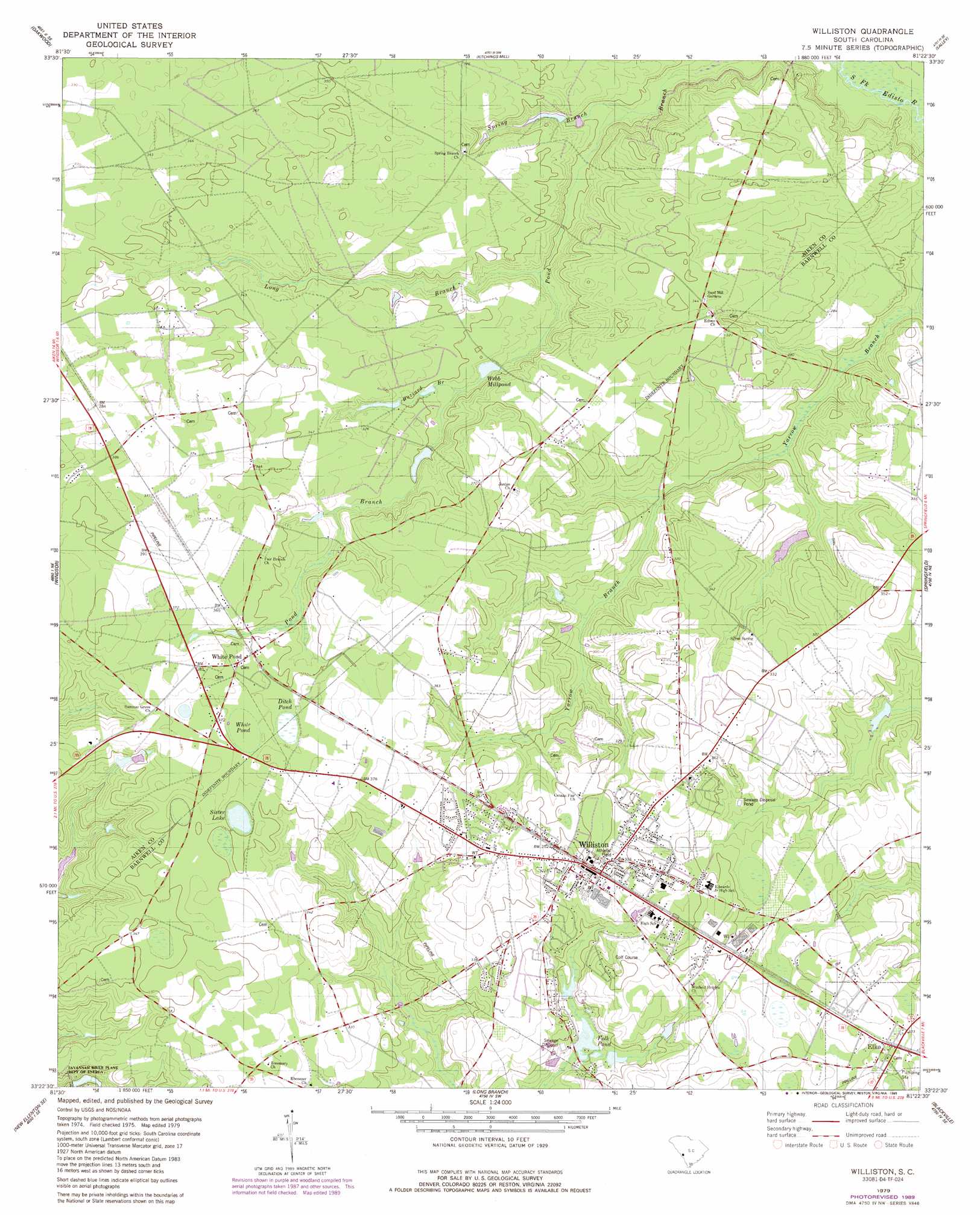
Williston Topo Map South Carolina
To zoom in, hover over the map of Williston
USGS Topo Quad 33081d4 - 1:24,000 scale
| Topo Map Name: | Williston |
| USGS Topo Quad ID: | 33081d4 |
| Print Size: | ca. 21 1/4" wide x 27" high |
| Southeast Coordinates: | 33.375° N latitude / 81.375° W longitude |
| Map Center Coordinates: | 33.4375° N latitude / 81.4375° W longitude |
| U.S. State: | SC |
| Filename: | o33081d4.jpg |
| Download Map JPG Image: | Williston topo map 1:24,000 scale |
| Map Type: | Topographic |
| Topo Series: | 7.5´ |
| Map Scale: | 1:24,000 |
| Source of Map Images: | United States Geological Survey (USGS) |
| Alternate Map Versions: |
Williston SC 1979, updated 1989 Download PDF Buy paper map Williston SC 2011 Download PDF Buy paper map Williston SC 2014 Download PDF Buy paper map |
| FStopo: | US Forest Service topo Williston is available: Download FStopo PDF Download FStopo TIF |
1:24,000 Topo Quads surrounding Williston
Aiken Nw |
Foxtown |
Seivern |
Wagener |
Pond Branch |
Aiken |
Oakwood |
Kitchings Mill |
Salley |
Harleys Millpond |
New Ellenton |
Windsor |
Williston |
Springfield |
Norway West |
New Ellenton Sw |
New Ellenton Se |
Long Branch |
Blackville |
Denmark |
Girard Nw |
Girard Ne |
Snelling |
Barnwell |
Olar |
> Back to 33081a1 at 1:100,000 scale
> Back to 33080a1 at 1:250,000 scale
> Back to U.S. Topo Maps home
Williston topo map: Gazetteer
Williston: Dams
Folks Lower Pond D-3053 Dam elevation 83m 272′Folks Upper Pond Dam D-3052 elevation 98m 321′
Johnsons Lake Dam D-2039 elevation 96m 314′
Jowers Pond Dam D-3048 elevation 80m 262′
South Carolina Noname 02042 D-2037 Dam elevation 79m 259′
Webbs Pond Dam D-2038 elevation 83m 272′
Whitehead Pond Dam D-2036 elevation 99m 324′
Williston: Lakes
Folk Pond elevation 83m 272′Sister Lake elevation 106m 347′
White Pond elevation 111m 364′
Williston: Populated Places
Elko elevation 103m 337′Spring Branch (historical) elevation 100m 328′
White Pond elevation 113m 370′
Williston elevation 108m 354′
Williston: Reservoirs
Bonnetts Mill Pond (historical) elevation 89m 291′Hallmans Pond elevation 79m 259′
Johnsons Lake elevation 96m 314′
Webb Millpond elevation 83m 272′
Webbs Pond elevation 92m 301′
Whitehead Pond elevation 99m 324′
Williston: Streams
Buzzard Branch elevation 85m 278′Long Branch elevation 76m 249′
Spring Branch elevation 72m 236′
Williston: Swamps
Ditch Pond elevation 109m 357′Williston digital topo map on disk
Buy this Williston topo map showing relief, roads, GPS coordinates and other geographical features, as a high-resolution digital map file on DVD:
South Carolina, Western North Carolina & Northeastern Georgia
Buy digital topo maps: South Carolina, Western North Carolina & Northeastern Georgia