New Ellenton Topo Map South Carolina
To zoom in, hover over the map of New Ellenton
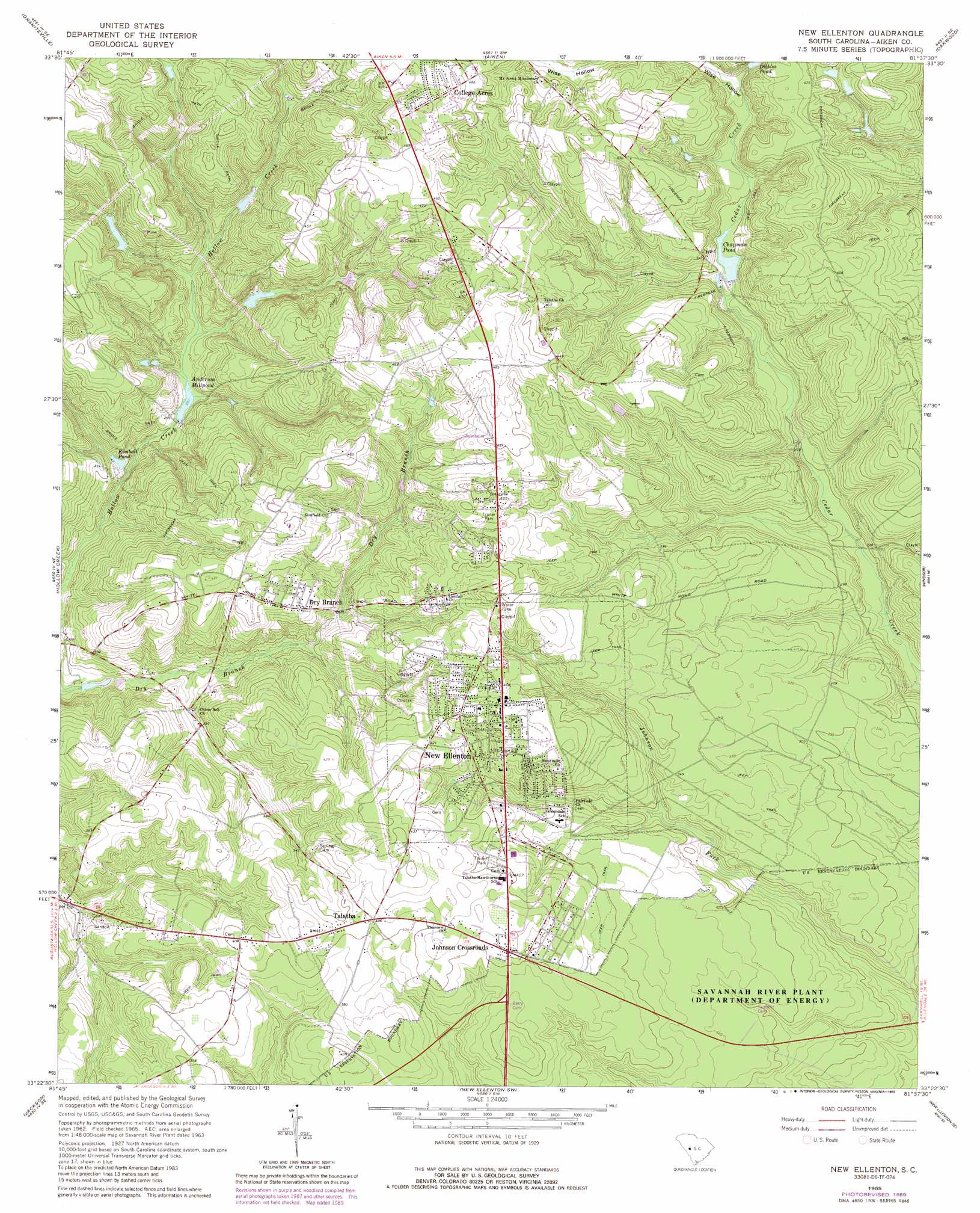
USGS Topo Quad 33081d6 - 1:24,000 scale
| Topo Map Name: | New Ellenton |
| USGS Topo Quad ID: | 33081d6 |
| Print Size: | ca. 21 1/4" wide x 27" high |
| Southeast Coordinates: | 33.375° N latitude / 81.625° W longitude |
| Map Center Coordinates: | 33.4375° N latitude / 81.6875° W longitude |
| U.S. State: | SC |
| Filename: | o33081d6.jpg |
| Download Map JPG Image: | New Ellenton topo map 1:24,000 scale |
| Map Type: | Topographic |
| Topo Series: | 7.5´ |
| Map Scale: | 1:24,000 |
| Source of Map Images: | United States Geological Survey (USGS) |
| Alternate Map Versions: |
New Ellenton SC 1965, updated 1967 Download PDF Buy paper map New Ellenton SC 1965, updated 1973 Download PDF Buy paper map New Ellenton SC 1965, updated 1989 Download PDF Buy paper map New Ellenton SC 2011 Download PDF Buy paper map New Ellenton SC 2014 Download PDF Buy paper map |
| FStopo: | US Forest Service topo New Ellenton is available: Download FStopo PDF Download FStopo TIF |
1:24,000 Topo Quads surrounding New Ellenton
Ropers Crossroads |
Trenton |
Aiken Nw |
Foxtown |
Seivern |
North Augusta |
Graniteville |
Aiken |
Oakwood |
Kitchings Mill |
Augusta East |
Hollow Creek |
New Ellenton |
Windsor |
Williston |
Mechanic Hill |
Jackson |
New Ellenton Sw |
New Ellenton Se |
Long Branch |
Mcbean |
Shell Bluff Landing |
Girard Nw |
Girard Ne |
Snelling |
> Back to 33081a1 at 1:100,000 scale
> Back to 33080a1 at 1:250,000 scale
> Back to U.S. Topo Maps home
New Ellenton topo map: Gazetteer
New Ellenton: Dams
South Carolina Noname 02018 D-2000 Dam elevation 79m 259′South Carolina Noname 02026 D-2004 Dam elevation 90m 295′
South Carolina Noname 02111 D-2049 Dam elevation 99m 324′
Williamson Lake Dam D-2050 elevation 95m 311′
New Ellenton: Lakes
Kimball Pond elevation 77m 252′New Ellenton: Populated Places
Brookhaven Estates elevation 133m 436′Chukker Creek elevation 134m 439′
College Acres elevation 149m 488′
Dry Branch elevation 119m 390′
Hunters Glen elevation 144m 472′
Johnson Crossroads elevation 125m 410′
New Ellenton elevation 125m 410′
Oak Hill elevation 129m 423′
Talatha elevation 124m 406′
Talatha Farms elevation 134m 439′
New Ellenton: Post Offices
New Ellenton Post Office elevation 125m 410′New Ellenton: Reservoirs
Anderson Millpond elevation 79m 259′Burdens Deep Pond elevation 99m 324′
Chapman Pond elevation 90m 295′
Dibbles Pond elevation 107m 351′
Hitchcock Mill Pond (historical) elevation 72m 236′
Holley Lake elevation 117m 383′
Williamson Lake elevation 95m 311′
New Ellenton: Valleys
Wise Hollow elevation 101m 331′New Ellenton digital topo map on disk
Buy this New Ellenton topo map showing relief, roads, GPS coordinates and other geographical features, as a high-resolution digital map file on DVD:
South Carolina, Western North Carolina & Northeastern Georgia
Buy digital topo maps: South Carolina, Western North Carolina & Northeastern Georgia