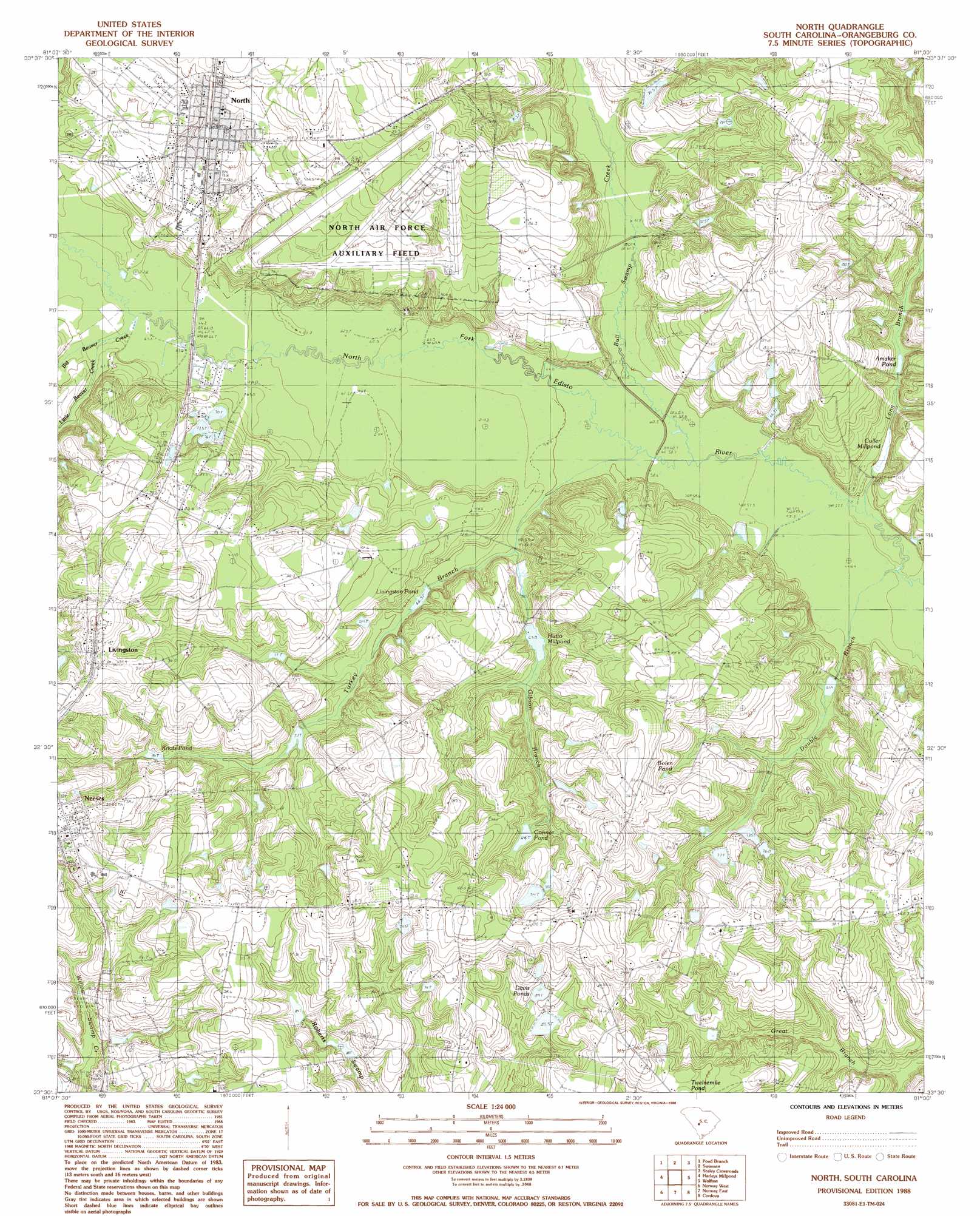
North Topo Map South Carolina
To zoom in, hover over the map of North
USGS Topo Quad 33081e1 - 1:24,000 scale
| Topo Map Name: | North |
| USGS Topo Quad ID: | 33081e1 |
| Print Size: | ca. 21 1/4" wide x 27" high |
| Southeast Coordinates: | 33.5° N latitude / 81° W longitude |
| Map Center Coordinates: | 33.5625° N latitude / 81.0625° W longitude |
| U.S. State: | SC |
| Filename: | o33081e1.jpg |
| Download Map JPG Image: | North topo map 1:24,000 scale |
| Map Type: | Topographic |
| Topo Series: | 7.5´ |
| Map Scale: | 1:24,000 |
| Source of Map Images: | United States Geological Survey (USGS) |
| Alternate Map Versions: |
North SC 1988, updated 1988 Download PDF Buy paper map North SC 2011 Download PDF Buy paper map North SC 2014 Download PDF Buy paper map |
1:24,000 Topo Quads surrounding North
Fairview Crossroads |
Pelion East |
Gaston |
Saylors Lake |
Gadsden |
Wagener |
Pond Branch |
Swansea |
Staley Crossroads |
Saint Mathews |
Salley |
Harleys Millpond |
North |
Wolfton |
Orangeburg North |
Springfield |
Norway West |
Norway East |
Cordova |
Orangeburg South |
Blackville |
Denmark |
Bamberg |
Midway |
Branchville North |
> Back to 33081e1 at 1:100,000 scale
> Back to 33080a1 at 1:250,000 scale
> Back to U.S. Topo Maps home
North topo map: Gazetteer
North: Airports
North Air Force Auxiliary Field elevation 94m 308′North: Bridges
Slab Landing Bridge elevation 59m 193′North: Dams
Bests Pond Dam D-3687 elevation 73m 239′Bonnettes Pond Dam D-3729 elevation 84m 275′
Bonnettes Ricefield Pond Dam D-2313 elevation 61m 200′
Boylston Pond Dam D-3709 elevation 78m 255′
Chaplin Pond Dam D-3705 elevation 65m 213′
Irene Davis Pond Dam D-3733 elevation 93m 305′
Mounts Pond Dam D-3708 elevation 82m 269′
South Carolina Noname 38038 D-3706 Dam elevation 68m 223′
South Carolina Noname 38039 D-2307 Dam elevation 70m 229′
South Carolina Noname 38040 D-3703 Dam elevation 73m 239′
South Carolina Noname 38042 D-3707 Dam elevation 86m 282′
South Carolina Noname 38049 D-3693 Dam elevation 61m 200′
W M Davis Pond Dam D-3735 elevation 95m 311′
Woods Pond Dam D-3704 elevation 68m 223′
North: Populated Places
Boiling Spring (historical) elevation 86m 282′Livingston elevation 101m 331′
Neeses elevation 104m 341′
North elevation 85m 278′
Pine Hill elevation 101m 331′
North: Post Offices
North Post Office elevation 84m 275′North: Reservoirs
Amaker Pond elevation 63m 206′Bolen Pond elevation 85m 278′
Conner Pond elevation 86m 282′
Connor Pond elevation 86m 282′
Culler Mill Pond elevation 61m 200′
Culler Millpond elevation 61m 200′
Davis Ponds elevation 87m 285′
H M Chapling Pond elevation 73m 239′
Hutto Mill Pond elevation 68m 223′
Hutto Millpond elevation 67m 219′
Knots Pond elevation 82m 269′
Livingston Pond elevation 66m 216′
Livingston Pond elevation 70m 229′
North: Streams
Big Beaver Creek elevation 63m 206′Bull Swamp Creek elevation 59m 193′
Double Branch elevation 57m 187′
Gibson Branch elevation 63m 206′
Little Beaver Creek elevation 65m 213′
Long Branch elevation 57m 187′
Turkey Branch elevation 59m 193′
North digital topo map on disk
Buy this North topo map showing relief, roads, GPS coordinates and other geographical features, as a high-resolution digital map file on DVD:
South Carolina, Western North Carolina & Northeastern Georgia
Buy digital topo maps: South Carolina, Western North Carolina & Northeastern Georgia