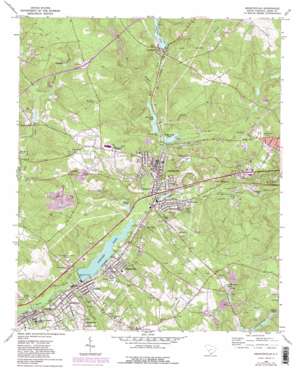
Graniteville Topo Map South Carolina
To zoom in, hover over the map of Graniteville
USGS Topo Quad 33081e7 - 1:24,000 scale
| Topo Map Name: | Graniteville |
| USGS Topo Quad ID: | 33081e7 |
| Print Size: | ca. 21 1/4" wide x 27" high |
| Southeast Coordinates: | 33.5° N latitude / 81.75° W longitude |
| Map Center Coordinates: | 33.5625° N latitude / 81.8125° W longitude |
| U.S. State: | SC |
| Filename: | o33081e7.jpg |
| Download Map JPG Image: | Graniteville topo map 1:24,000 scale |
| Map Type: | Topographic |
| Topo Series: | 7.5´ |
| Map Scale: | 1:24,000 |
| Source of Map Images: | United States Geological Survey (USGS) |
| Alternate Map Versions: |
Graniteville SC 1964, updated 1965 Download PDF Buy paper map Graniteville SC 1964, updated 1981 Download PDF Buy paper map Graniteville SC 1964, updated 1981 Download PDF Buy paper map Graniteville SC 1971 Download PDF Buy paper map Graniteville SC 2011 Download PDF Buy paper map Graniteville SC 2014 Download PDF Buy paper map |
1:24,000 Topo Quads surrounding Graniteville
> Back to 33081e1 at 1:100,000 scale
> Back to 33080a1 at 1:250,000 scale
> Back to U.S. Topo Maps home
Graniteville topo map: Gazetteer
Graniteville: Crossings
Interchange 11 elevation 136m 446′Graniteville: Dams
South Carolina Noname 02001 Dam elevation 47m 154′South Carolina Noname 02004 Dam elevation 85m 278′
South Carolina Noname 02005 Dam elevation 69m 226′
South Carolina Noname 02006 Dam elevation 72m 236′
South Carolina Noname 02016 D-0696 Dam elevation 96m 314′
South Carolina Noname 02034 D-2128 Dam elevation 124m 406′
South Carolina Noname 02035 D-2129 Dam elevation 102m 334′
South Carolina Noname 02051 D-2010 Dam elevation 100m 328′
South Carolina Noname 02058 D-0755 Dam elevation 97m 318′
South Carolina Noname 02087 D-2041 Dam elevation 84m 275′
South Carolina Noname 02112 D-2134 Dam elevation 149m 488′
Suhrer Lake Dam D-2137 elevation 110m 360′
Graniteville: Lakes
Bridge Creek Pond elevation 69m 226′Richardsons Lake elevation 120m 393′
Robinson Pond elevation 77m 252′
Graniteville: Parks
Gregg Park elevation 73m 239′Gregg Park elevation 65m 213′
Graniteville: Populated Places
Aiken Heights elevation 140m 459′Bath elevation 50m 164′
Briarcliff elevation 150m 492′
Burnettown elevation 54m 177′
Deerwood elevation 147m 482′
Foxchase elevation 148m 485′
Gloverville elevation 62m 203′
Graniteville elevation 71m 232′
Gregg Park elevation 88m 288′
Huntcliff elevation 139m 456′
Jacksonville elevation 93m 305′
Kalmia Hills elevation 138m 452′
Kalmia Landing elevation 145m 475′
Langley elevation 59m 193′
Langley Villa elevation 96m 314′
Lynwood elevation 52m 170′
Madison elevation 64m 209′
Midland Valley elevation 69m 226′
Mixville elevation 69m 226′
Pineview Acres elevation 139m 456′
Rainbow Falls elevation 88m 288′
Rennie (historical) elevation 70m 229′
Southwood elevation 138m 452′
Springdale elevation 113m 370′
Stiefeltown elevation 70m 229′
Vaucluse elevation 101m 331′
Warrenville elevation 71m 232′
Westcliff elevation 94m 308′
Graniteville: Reservoirs
Bartons Pond (historical) elevation 82m 269′Flat Rock Pond elevation 67m 219′
Flat Rock/Bridge Creek Ponds elevation 69m 226′
Gem Lake elevation 149m 488′
Graniteville Pond Two elevation 72m 236′
Horse Creek Pond elevation 47m 154′
Langley Pond elevation 55m 180′
Outing Lake elevation 96m 314′
Suhrer Lake elevation 110m 360′
Vaucluse Pond elevation 85m 278′
Williams Lake elevation 84m 275′
Wilson Pond elevation 112m 367′
Graniteville: Streams
Bridge Creek elevation 70m 229′Camp Branch elevation 87m 285′
Good Spring Branch elevation 72m 236′
Hightower Creek elevation 64m 209′
Horsepen Creek elevation 83m 272′
Sage Mill Branch elevation 68m 223′
Sand River elevation 53m 173′
Graniteville digital topo map on disk
Buy this Graniteville topo map showing relief, roads, GPS coordinates and other geographical features, as a high-resolution digital map file on DVD:
South Carolina, Western North Carolina & Northeastern Georgia
Buy digital topo maps: South Carolina, Western North Carolina & Northeastern Georgia


