Saluda South Topo Map South Carolina
To zoom in, hover over the map of Saluda South
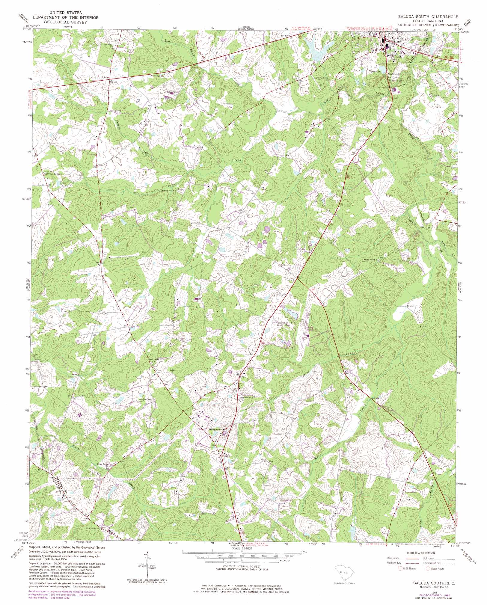
USGS Topo Quad 33081h7 - 1:24,000 scale
| Topo Map Name: | Saluda South |
| USGS Topo Quad ID: | 33081h7 |
| Print Size: | ca. 21 1/4" wide x 27" high |
| Southeast Coordinates: | 33.875° N latitude / 81.75° W longitude |
| Map Center Coordinates: | 33.9375° N latitude / 81.8125° W longitude |
| U.S. State: | SC |
| Filename: | o33081h7.jpg |
| Download Map JPG Image: | Saluda South topo map 1:24,000 scale |
| Map Type: | Topographic |
| Topo Series: | 7.5´ |
| Map Scale: | 1:24,000 |
| Source of Map Images: | United States Geological Survey (USGS) |
| Alternate Map Versions: |
Saluda South SC 1964, updated 1965 Download PDF Buy paper map Saluda South SC 1964, updated 1982 Download PDF Buy paper map Saluda South SC 2011 Download PDF Buy paper map Saluda South SC 2014 Download PDF Buy paper map |
1:24,000 Topo Quads surrounding Saluda South
Ninety Six |
Dyson |
Chappells |
Silverstreet |
Prosperity |
Kirksey |
Good Hope |
Saluda North |
Denny |
Delmar |
Limestone |
Owdoms |
Saluda South |
Emory |
Batesburg |
Red Hill |
Edgefield |
Johnston |
Ridge Spring |
Monetta |
Colliers |
Ropers Crossroads |
Trenton |
Aiken Nw |
Foxtown |
> Back to 33081e1 at 1:100,000 scale
> Back to 33080a1 at 1:250,000 scale
> Back to U.S. Topo Maps home
Saluda South topo map: Gazetteer
Saluda South: Airports
Etheredge Plantation Airport elevation 138m 452′Saluda County Airport elevation 165m 541′
Saluda South: Dams
Old Saluda Reservoir Dam D-0031 elevation 135m 442′Routons Pond Dam D-1201 elevation 153m 501′
South Carolina Noname 41001 D-1196 Dam elevation 135m 442′
South Carolina Noname 41011 D-1202 Dam elevation 149m 488′
Yances Pond Dam D-1596 elevation 162m 531′
Saluda South: Populated Places
Fruit Hill elevation 160m 524′Limp elevation 156m 511′
Mathais Crossroads elevation 165m 541′
Saluda South: Reservoirs
New Saluda Reservoir elevation 135m 442′Old Saluda Reservoir elevation 135m 442′
Routons Pond elevation 153m 501′
Yances Pond elevation 162m 531′
Saluda South: Streams
Dry Creek elevation 125m 410′Little Mine Creek elevation 133m 436′
Mine Creek elevation 118m 387′
Penn Creek elevation 125m 410′
Red Bank Creek elevation 122m 400′
Salem Branch elevation 133m 436′
Saluda South digital topo map on disk
Buy this Saluda South topo map showing relief, roads, GPS coordinates and other geographical features, as a high-resolution digital map file on DVD:
South Carolina, Western North Carolina & Northeastern Georgia
Buy digital topo maps: South Carolina, Western North Carolina & Northeastern Georgia