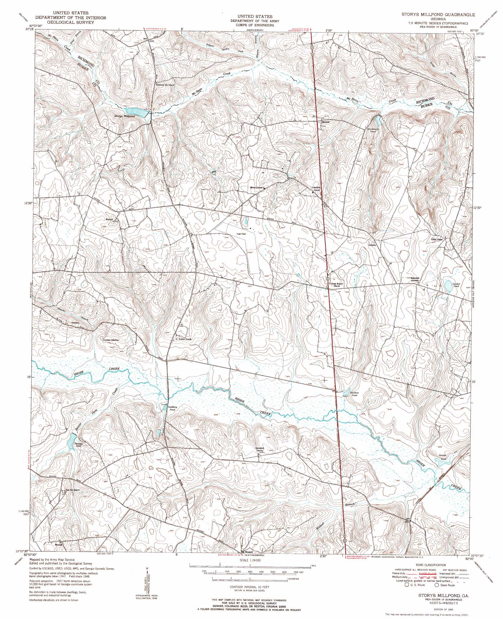
Storys Millpond Topo Map Georgia
To zoom in, hover over the map of Storys Millpond
USGS Topo Quad 33082b1 - 1:24,000 scale
| Topo Map Name: | Storys Millpond |
| USGS Topo Quad ID: | 33082b1 |
| Print Size: | ca. 21 1/4" wide x 27" high |
| Southeast Coordinates: | 33.125° N latitude / 82° W longitude |
| Map Center Coordinates: | 33.1875° N latitude / 82.0625° W longitude |
| U.S. State: | GA |
| Filename: | o33082b1.jpg |
| Download Map JPG Image: | Storys Millpond topo map 1:24,000 scale |
| Map Type: | Topographic |
| Topo Series: | 7.5´ |
| Map Scale: | 1:24,000 |
| Source of Map Images: | United States Geological Survey (USGS) |
| Alternate Map Versions: |
Storys Millpond GA 1950 Download PDF Buy paper map Storys Millpond GA 1950 Download PDF Buy paper map Storys Millpond GA 2011 Download PDF Buy paper map Storys Millpond GA 2014 Download PDF Buy paper map |
1:24,000 Topo Quads surrounding Storys Millpond
Harlem |
Grovetown |
Augusta West |
Augusta East |
Hollow Creek |
Avondale |
Blythe |
Hephzibah |
Mechanic Hill |
Jackson |
Matthews |
Keysville |
Storys Millpond |
Mcbean |
Shell Bluff Landing |
Kellys Pond |
Gough |
Waynesboro |
Idlewood |
Alexander |
Old Town |
Scotts Corner |
Bellevue |
Perkins |
Sardis |
> Back to 33082a1 at 1:100,000 scale
> Back to 33082a1 at 1:250,000 scale
> Back to U.S. Topo Maps home
Storys Millpond topo map: Gazetteer
Storys Millpond: Airports
Yawn Field elevation 95m 311′Storys Millpond: Bridges
Walkers Bridge elevation 63m 206′Storys Millpond: Dams
Shaw Lake Dam elevation 58m 190′Storys Millpond Dam elevation 60m 196′
Storys Millpond: Populated Places
Grove Mount elevation 94m 308′Storys Millpond: Reservoirs
Goldberg Pond elevation 64m 209′Gordon Pond elevation 86m 282′
Palmers Pond elevation 68m 223′
Satchel Pond elevation 58m 190′
Shaw Lake elevation 58m 190′
Stockton Pond elevation 61m 200′
Storys Millpond elevation 60m 196′
Storys Millpond elevation 60m 196′
Woodwards Pond elevation 49m 160′
Storys Millpond: Streams
Allen Branch elevation 45m 147′Beaver Dam Creek elevation 63m 206′
Hopeful Branch elevation 63m 206′
Jennys Branch elevation 44m 144′
New Hope Branch elevation 63m 206′
Rebecca Walker Creek elevation 51m 167′
Rock Hill Branch elevation 47m 154′
Walnut Branch elevation 56m 183′
Wheeler Branch elevation 52m 170′
Storys Millpond digital topo map on disk
Buy this Storys Millpond topo map showing relief, roads, GPS coordinates and other geographical features, as a high-resolution digital map file on DVD:
South Carolina, Western North Carolina & Northeastern Georgia
Buy digital topo maps: South Carolina, Western North Carolina & Northeastern Georgia