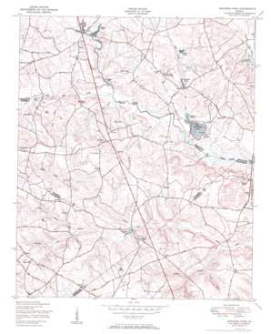
Bowdens Pond Topo Map Georgia
To zoom in, hover over the map of Bowdens Pond
USGS Topo Quad 33082c4 - 1:24,000 scale
| Topo Map Name: | Bowdens Pond |
| USGS Topo Quad ID: | 33082c4 |
| Print Size: | ca. 21 1/4" wide x 27" high |
| Southeast Coordinates: | 33.25° N latitude / 82.375° W longitude |
| Map Center Coordinates: | 33.3125° N latitude / 82.4375° W longitude |
| U.S. State: | GA |
| Filename: | o33082c4.jpg |
| Download Map JPG Image: | Bowdens Pond topo map 1:24,000 scale |
| Map Type: | Topographic |
| Topo Series: | 7.5´ |
| Map Scale: | 1:24,000 |
| Source of Map Images: | United States Geological Survey (USGS) |
| Alternate Map Versions: |
Bowdens Pond GA 1950 Download PDF Buy paper map Bowdens Pond GA 1950, updated 1955 Download PDF Buy paper map Bowdens Pond GA 2011 Download PDF Buy paper map Bowdens Pond GA 2014 Download PDF Buy paper map |
1:24,000 Topo Quads surrounding Bowdens Pond
> Back to 33082a1 at 1:100,000 scale
> Back to 33082a1 at 1:250,000 scale
> Back to U.S. Topo Maps home
Bowdens Pond topo map: Gazetteer
Bowdens Pond: Bridges
Huff Bridge elevation 91m 298′Luckie Bridge elevation 88m 288′
Bowdens Pond: Dams
Bowdens Pond Dam Number One elevation 90m 295′Bowdens Pond Dam Number Two elevation 92m 301′
Huber Lake Dam elevation 121m 396′
Johnson Dam elevation 113m 370′
Johnson Pond Dam elevation 105m 344′
Kaolin Lake Dam elevation 112m 367′
Kaolin Mines Lake Dam elevation 114m 374′
Langham Dam elevation 141m 462′
Simons Pond Dam elevation 108m 354′
Bowdens Pond: Gaps
Little Brasstown Gap elevation 95m 311′Bowdens Pond: Populated Places
Autney elevation 125m 410′David (historical) elevation 152m 498′
Hadden elevation 157m 515′
Happy Valley elevation 117m 383′
Bowdens Pond: Reservoirs
Arrington Pond (historical) elevation 97m 318′Arringtons Pond elevation 100m 328′
Bowdens Pond elevation 90m 295′
Bowdens Pond Number One elevation 90m 295′
Bowdens Pond Number Two elevation 92m 301′
Bradshaw Lake elevation 97m 318′
Hobbs Pond elevation 105m 344′
Huber Lake elevation 121m 396′
Johnson Lake elevation 113m 370′
Johnson Pond elevation 105m 344′
Kaolin Lake elevation 113m 370′
Kaolin Mines Lake elevation 114m 374′
Langham Lake elevation 141m 462′
Magahee Ponds elevation 103m 337′
Newsomes Pond elevation 112m 367′
Prescott Pond elevation 96m 314′
Simons Pond elevation 108m 354′
Bowdens Pond: Streams
Fort Creek elevation 92m 301′Gin Branch elevation 118m 387′
Guy Branch elevation 102m 334′
Howard Branch elevation 105m 344′
Little Brier Creek elevation 94m 308′
Mill Branch elevation 94m 308′
Rayburn Branch elevation 100m 328′
Sweetwater Creek elevation 107m 351′
Thompson Branch elevation 88m 288′
Thomson Ford Branch elevation 109m 357′
Bowdens Pond digital topo map on disk
Buy this Bowdens Pond topo map showing relief, roads, GPS coordinates and other geographical features, as a high-resolution digital map file on DVD:
South Carolina, Western North Carolina & Northeastern Georgia
Buy digital topo maps: South Carolina, Western North Carolina & Northeastern Georgia


