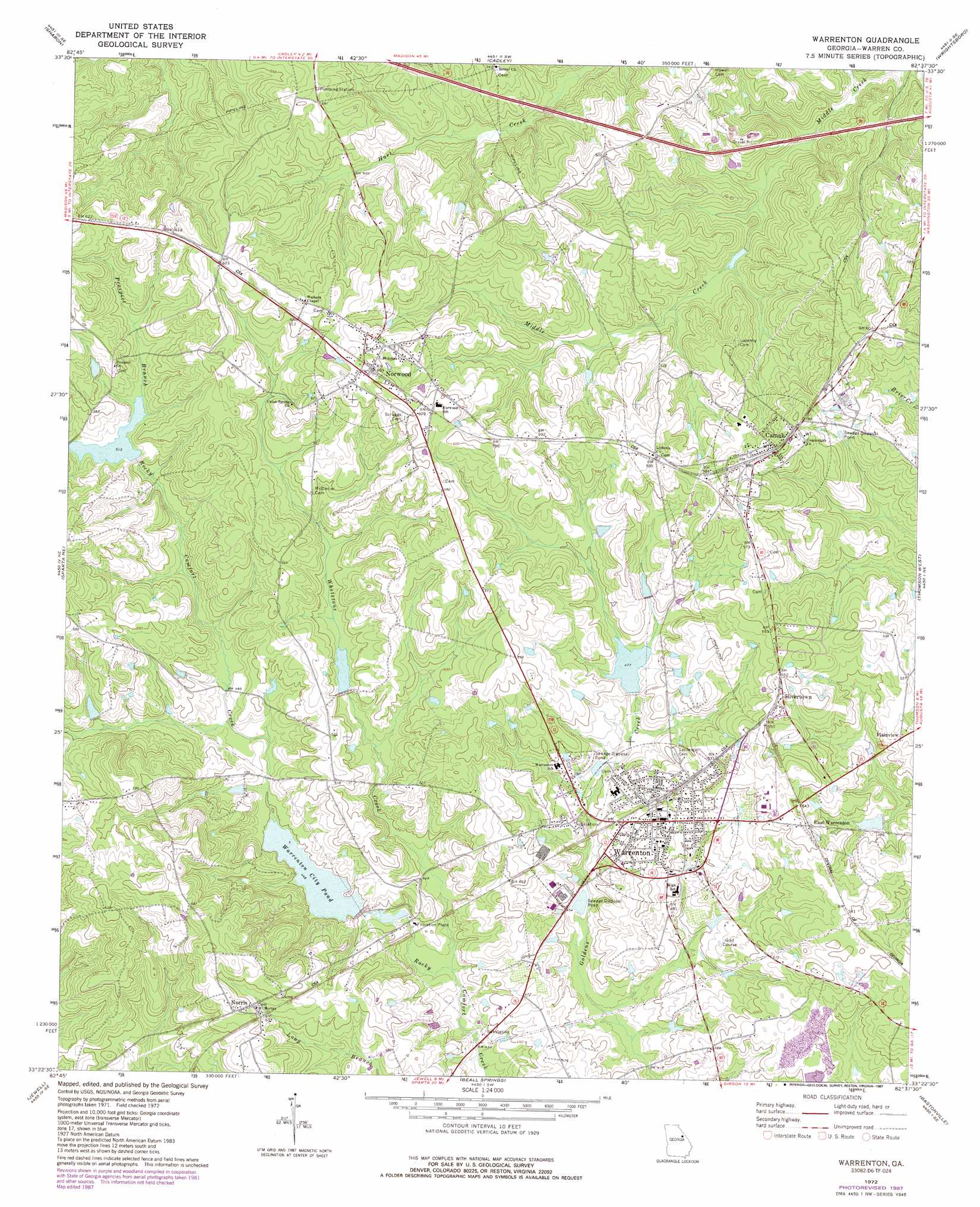
Warrenton Topo Map Georgia
To zoom in, hover over the map of Warrenton
USGS Topo Quad 33082d6 - 1:24,000 scale
| Topo Map Name: | Warrenton |
| USGS Topo Quad ID: | 33082d6 |
| Print Size: | ca. 21 1/4" wide x 27" high |
| Southeast Coordinates: | 33.375° N latitude / 82.625° W longitude |
| Map Center Coordinates: | 33.4375° N latitude / 82.6875° W longitude |
| U.S. State: | GA |
| Filename: | o33082d6.jpg |
| Download Map JPG Image: | Warrenton topo map 1:24,000 scale |
| Map Type: | Topographic |
| Topo Series: | 7.5´ |
| Map Scale: | 1:24,000 |
| Source of Map Images: | United States Geological Survey (USGS) |
| Alternate Map Versions: |
Warrenton GA 1972, updated 1975 Download PDF Buy paper map Warrenton GA 2011 Download PDF Buy paper map Warrenton GA 2014 Download PDF Buy paper map |
1:24,000 Topo Quads surrounding Warrenton
Philomath |
Washington West |
Washington East |
Aonia |
Woodlawn |
Crawfordville |
Sharon |
Cadley |
Wrightsboro |
Winfield |
Sparta Nw |
Sparta Ne |
Warrenton |
Thomson West |
Thompson East |
Sparta |
Jewell |
Beall Springs |
Bastonville |
Bowdens Pond |
Warthen Nw |
Warthen Ne |
Mitchell |
Gibson |
Wrens |
> Back to 33082a1 at 1:100,000 scale
> Back to 33082a1 at 1:250,000 scale
> Back to U.S. Topo Maps home
Warrenton topo map: Gazetteer
Warrenton: Dams
Aggregates Lake Dam elevation 144m 472′English Lake Dam elevation 142m 465′
Johnson Dam elevation 145m 475′
Kitchens Lake Dam elevation 145m 475′
Nelson Dam elevation 152m 498′
Rocky Comfort Creek Structure Number 14 Dam elevation 147m 482′
Rocky Comfort Creek Watershed Number 45 Dam elevation 147m 482′
South Sewage Disposal Pond Dam elevation 131m 429′
Warrenton: Populated Places
Camak elevation 180m 590′East Warrenton elevation 164m 538′
Norris elevation 174m 570′
Norwood elevation 186m 610′
Plainview elevation 159m 521′
Silvertown elevation 168m 551′
Warrenton elevation 159m 521′
Warrenton: Post Offices
Warrenton Post Office elevation 153m 501′Warrenton: Reservoirs
Aggregates Lake elevation 144m 472′English Lake elevation 142m 465′
Johnsons Lake elevation 145m 475′
Kitchens Lake elevation 145m 475′
Nelson Lake elevation 152m 498′
Reservoir 14 elevation 147m 482′
South Sewage Disposal Pond elevation 131m 429′
Warrenton City Pond elevation 139m 456′
Warrenton: Streams
Prospect Branch elevation 157m 515′Whetstone Creek elevation 129m 423′
Warrenton digital topo map on disk
Buy this Warrenton topo map showing relief, roads, GPS coordinates and other geographical features, as a high-resolution digital map file on DVD:
South Carolina, Western North Carolina & Northeastern Georgia
Buy digital topo maps: South Carolina, Western North Carolina & Northeastern Georgia