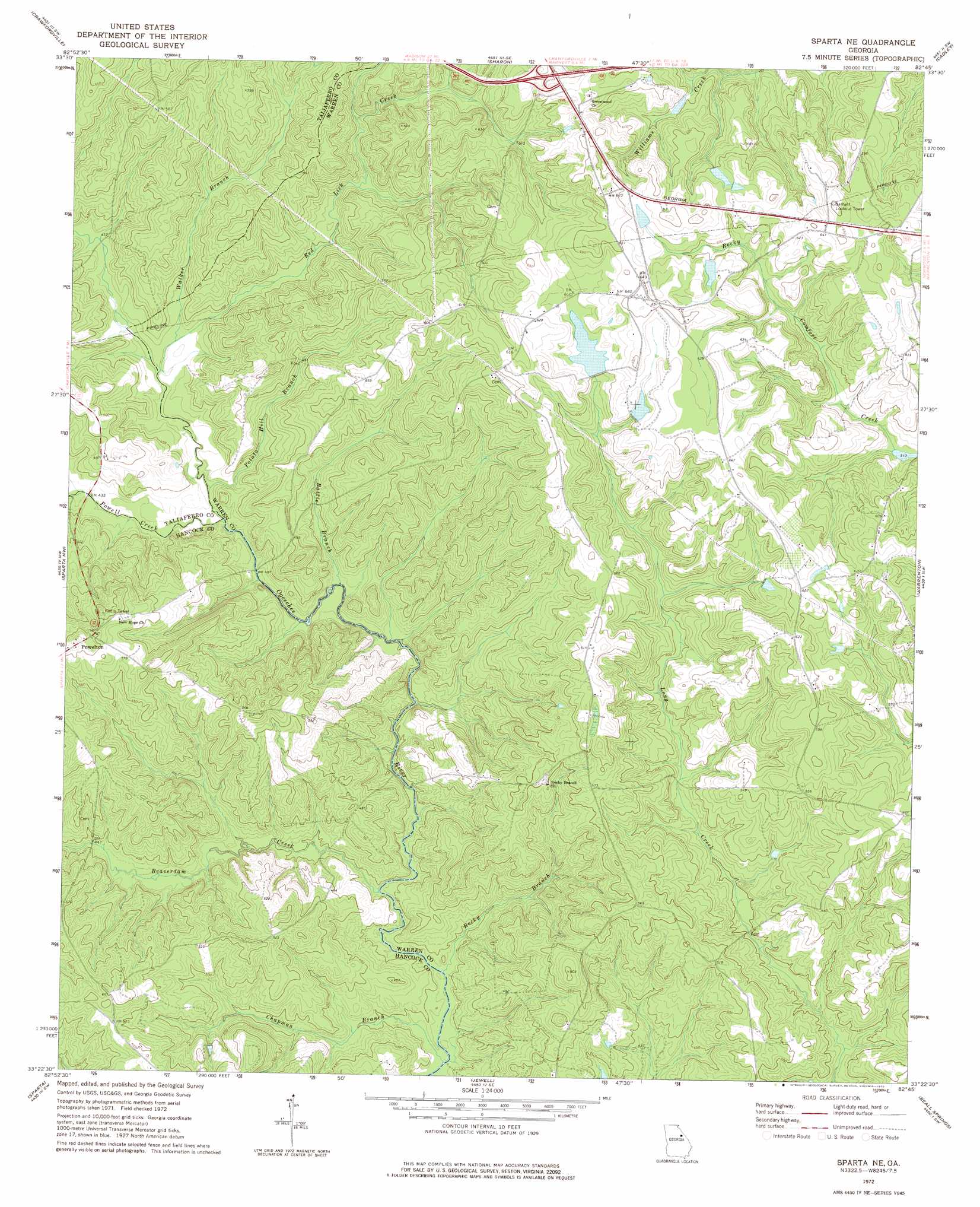
Sparta Ne Topo Map Georgia
To zoom in, hover over the map of Sparta Ne
USGS Topo Quad 33082d7 - 1:24,000 scale
| Topo Map Name: | Sparta Ne |
| USGS Topo Quad ID: | 33082d7 |
| Print Size: | ca. 21 1/4" wide x 27" high |
| Southeast Coordinates: | 33.375° N latitude / 82.75° W longitude |
| Map Center Coordinates: | 33.4375° N latitude / 82.8125° W longitude |
| U.S. State: | GA |
| Filename: | o33082d7.jpg |
| Download Map JPG Image: | Sparta Ne topo map 1:24,000 scale |
| Map Type: | Topographic |
| Topo Series: | 7.5´ |
| Map Scale: | 1:24,000 |
| Source of Map Images: | United States Geological Survey (USGS) |
| Alternate Map Versions: |
Sparta NE GA 1972, updated 1975 Download PDF Buy paper map Sparta NE GA 1972, updated 1991 Download PDF Buy paper map Sparta NE GA 2011 Download PDF Buy paper map Sparta NE GA 2014 Download PDF Buy paper map |
1:24,000 Topo Quads surrounding Sparta Ne
Woodville |
Philomath |
Washington West |
Washington East |
Aonia |
Union Point |
Crawfordville |
Sharon |
Cadley |
Wrightsboro |
White Plains |
Sparta Nw |
Sparta Ne |
Warrenton |
Thomson West |
Shoulderbone |
Sparta |
Jewell |
Beall Springs |
Bastonville |
Devereux |
Warthen Nw |
Warthen Ne |
Mitchell |
Gibson |
> Back to 33082a1 at 1:100,000 scale
> Back to 33082a1 at 1:250,000 scale
> Back to U.S. Topo Maps home
Sparta Ne topo map: Gazetteer
Sparta Ne: Crossings
Exit 56 elevation 198m 649′Sparta Ne: Dams
Chafin Dam elevation 185m 606′Neal Lake Dam elevation 190m 623′
Reservoir Lake Dam elevation 137m 449′
Shivers Dam Number One elevation 178m 583′
Shivers Dam Two elevation 186m 610′
Shivers Lake Dam elevation 188m 616′
Sparta Ne: Parks
William Rabun Monument elevation 178m 583′Sparta Ne: Populated Places
Powelton elevation 184m 603′Sparta Ne: Reservoirs
Chafin Lake elevation 185m 606′Neal Lake elevation 190m 623′
Reservoir Lake elevation 137m 449′
Shivers Lake elevation 188m 616′
Shivers Lake Number One elevation 178m 583′
Shivers Lake Two elevation 186m 610′
Sparta Ne: Streams
Battle Branch elevation 122m 400′Beaverdam Creek elevation 118m 387′
Chapman Branch elevation 117m 383′
Potato Hill Branch elevation 124m 406′
Powell Creek elevation 123m 403′
Red Lick Creek elevation 127m 416′
Rocky Branch elevation 118m 387′
Walker Branch elevation 128m 419′
Sparta Ne digital topo map on disk
Buy this Sparta Ne topo map showing relief, roads, GPS coordinates and other geographical features, as a high-resolution digital map file on DVD:
South Carolina, Western North Carolina & Northeastern Georgia
Buy digital topo maps: South Carolina, Western North Carolina & Northeastern Georgia