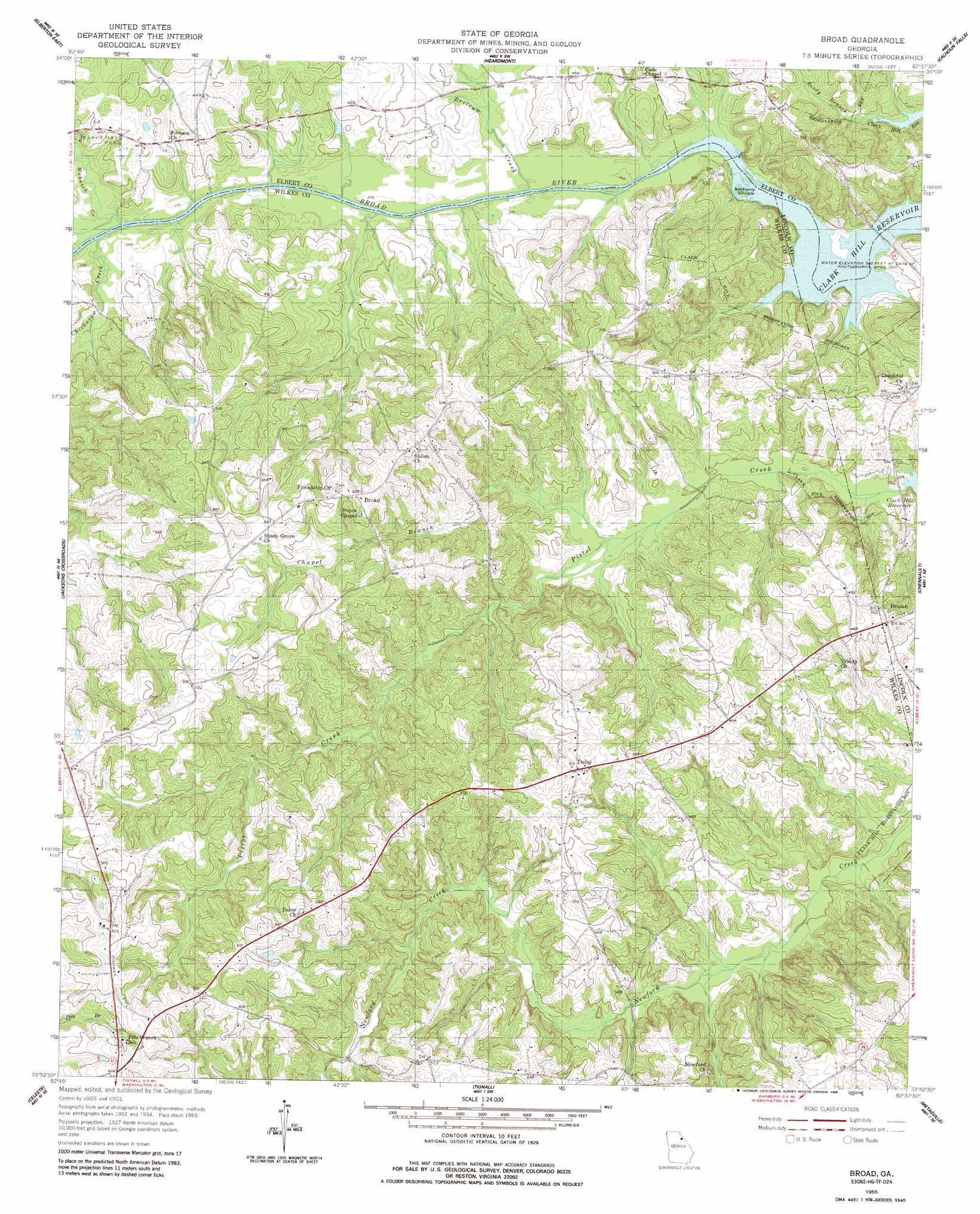
Broad Topo Map Georgia
To zoom in, hover over the map of Broad
USGS Topo Quad 33082h6 - 1:24,000 scale
| Topo Map Name: | Broad |
| USGS Topo Quad ID: | 33082h6 |
| Print Size: | ca. 21 1/4" wide x 27" high |
| Southeast Coordinates: | 33.875° N latitude / 82.625° W longitude |
| Map Center Coordinates: | 33.9375° N latitude / 82.6875° W longitude |
| U.S. State: | GA |
| Filename: | o33082h6.jpg |
| Download Map JPG Image: | Broad topo map 1:24,000 scale |
| Map Type: | Topographic |
| Topo Series: | 7.5´ |
| Map Scale: | 1:24,000 |
| Source of Map Images: | United States Geological Survey (USGS) |
| Alternate Map Versions: |
Broad GA 1955, updated 1956 Download PDF Buy paper map Broad GA 1955, updated 1986 Download PDF Buy paper map Broad GA 2011 Download PDF Buy paper map Broad GA 2014 Download PDF Buy paper map |
1:24,000 Topo Quads surrounding Broad
Dewy Rose |
Rock Branch |
Lowndesville |
Latimer |
Abbeville West |
Elberton West |
Elberton East |
Heardmont |
Calhoun Falls |
Calhoun Creek |
Vesta |
Jacksons Crossroads |
Broad |
Chennault |
Willington |
Rayle |
Celeste |
Tignall |
Metasville |
Lincolnton |
Philomath |
Washington West |
Washington East |
Aonia |
Woodlawn |
> Back to 33082e1 at 1:100,000 scale
> Back to 33082a1 at 1:250,000 scale
> Back to U.S. Topo Maps home
Broad topo map: Gazetteer
Broad: Bars
Anthony Shoals elevation 91m 298′Broad: Crossings
Anthony Ferry (historical) elevation 91m 298′Bakers Ferry (historical) elevation 111m 364′
Broad: Islands
Green Island elevation 112m 367′Broad: Parks
Nancy Hart State Park elevation 120m 393′Broad: Populated Places
Beulah elevation 140m 459′Broad elevation 161m 528′
Delhi elevation 162m 531′
Dyson (historical) elevation 161m 528′
Huguenot (historical) elevation 153m 501′
Broad: Streams
Bertram Creek elevation 111m 364′Chapel Branch elevation 114m 374′
Chickasaw Creek elevation 110m 360′
Killico Branch elevation 116m 380′
Reedy Branch elevation 101m 331′
Wahachee Creek elevation 111m 364′
Broad digital topo map on disk
Buy this Broad topo map showing relief, roads, GPS coordinates and other geographical features, as a high-resolution digital map file on DVD:
South Carolina, Western North Carolina & Northeastern Georgia
Buy digital topo maps: South Carolina, Western North Carolina & Northeastern Georgia