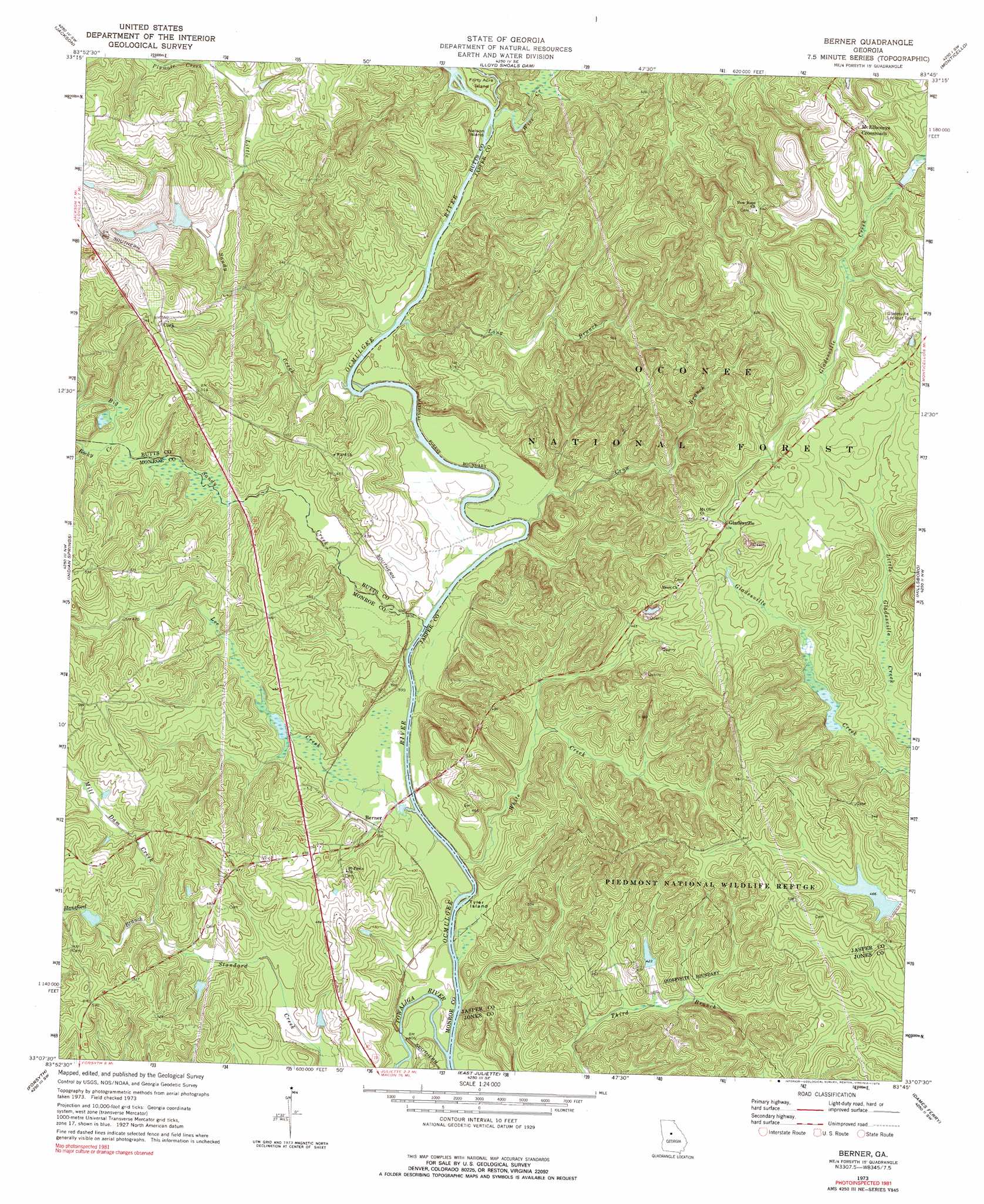
Berner Topo Map Georgia
To zoom in, hover over the map of Berner
USGS Topo Quad 33083b7 - 1:24,000 scale
| Topo Map Name: | Berner |
| USGS Topo Quad ID: | 33083b7 |
| Print Size: | ca. 21 1/4" wide x 27" high |
| Southeast Coordinates: | 33.125° N latitude / 83.75° W longitude |
| Map Center Coordinates: | 33.1875° N latitude / 83.8125° W longitude |
| U.S. State: | GA |
| Filename: | o33083b7.jpg |
| Download Map JPG Image: | Berner topo map 1:24,000 scale |
| Map Type: | Topographic |
| Topo Series: | 7.5´ |
| Map Scale: | 1:24,000 |
| Source of Map Images: | United States Geological Survey (USGS) |
| Alternate Map Versions: |
Berner GA 1973, updated 1975 Download PDF Buy paper map Berner GA 1973, updated 1975 Download PDF Buy paper map Berner GA 2011 Download PDF Buy paper map Berner GA 2014 Download PDF Buy paper map |
| FStopo: | US Forest Service topo Berner is available: Download FStopo PDF Download FStopo TIF |
1:24,000 Topo Quads surrounding Berner
Ola |
Worthville |
Stewart |
Farrar |
Shady Dale |
Locust Grove |
Jackson |
Lloyd Shoals Dam |
Monticello |
Smithboro |
High Falls |
Indian Springs |
Berner |
Hillsboro |
Stanfordville |
Johnstonville |
Forsyth |
East Juliette |
Dames Ferry |
Gray |
Strouds |
Smarr |
Bolingbroke |
Macon Nw |
Macon Ne |
> Back to 33083a1 at 1:100,000 scale
> Back to 33082a1 at 1:250,000 scale
> Back to U.S. Topo Maps home
Berner topo map: Gazetteer
Berner: Bridges
Bill Key Bridge elevation 110m 360′Berner: Crossings
Bridges Ferry (historical) elevation 110m 360′Goodman Ferry (historical) elevation 122m 400′
Lamars Ferry (historical) elevation 116m 380′
Waits Ferry (historical) elevation 113m 370′
Berner: Islands
Forty Acre Island elevation 124m 406′Nelson Island elevation 118m 387′
Tyler Island elevation 110m 360′
Berner: Populated Places
Berner elevation 120m 393′Cork elevation 168m 551′
Gladesville elevation 152m 498′
McElheneys Crossroads elevation 193m 633′
Berner: Streams
Big Sandy Creek elevation 113m 370′Crow Branch elevation 115m 377′
Douglas Creek elevation 143m 469′
Hansford Branch elevation 129m 423′
Lee Creek elevation 110m 360′
Little Sandy Creek elevation 113m 370′
Long Branch elevation 117m 383′
Mill Dam Creek elevation 131m 429′
Plymale Creek elevation 143m 469′
Rocky Creek elevation 126m 413′
Towaliga River elevation 110m 360′
White Creek elevation 116m 380′
Wise Creek elevation 118m 387′
Berner: Trails
Ocmulgee River Trail elevation 118m 387′Berner digital topo map on disk
Buy this Berner topo map showing relief, roads, GPS coordinates and other geographical features, as a high-resolution digital map file on DVD:
South Carolina, Western North Carolina & Northeastern Georgia
Buy digital topo maps: South Carolina, Western North Carolina & Northeastern Georgia