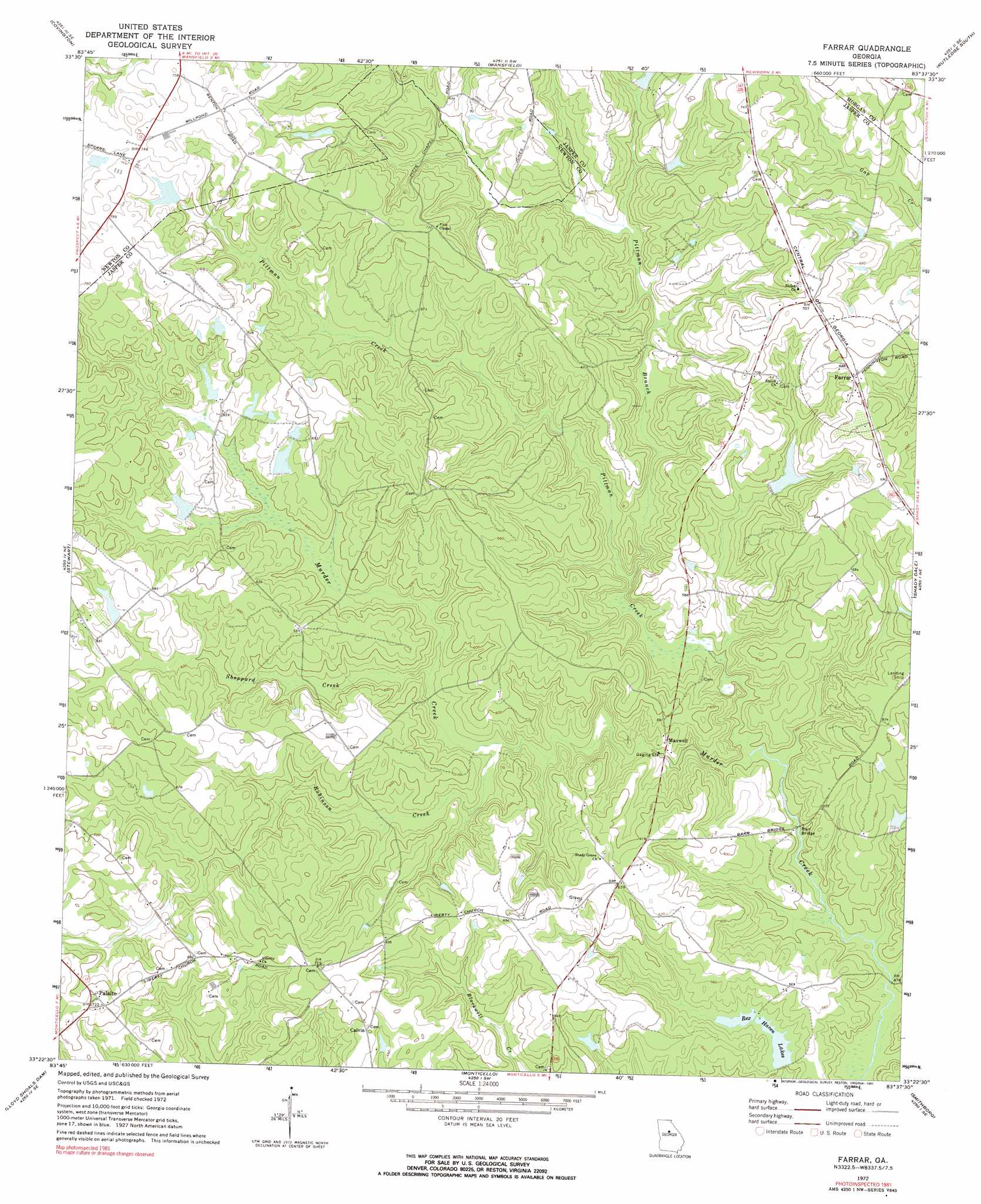
Farrar Topo Map Georgia
To zoom in, hover over the map of Farrar
USGS Topo Quad 33083d6 - 1:24,000 scale
| Topo Map Name: | Farrar |
| USGS Topo Quad ID: | 33083d6 |
| Print Size: | ca. 21 1/4" wide x 27" high |
| Southeast Coordinates: | 33.375° N latitude / 83.625° W longitude |
| Map Center Coordinates: | 33.4375° N latitude / 83.6875° W longitude |
| U.S. State: | GA |
| Filename: | o33083d6.jpg |
| Download Map JPG Image: | Farrar topo map 1:24,000 scale |
| Map Type: | Topographic |
| Topo Series: | 7.5´ |
| Map Scale: | 1:24,000 |
| Source of Map Images: | United States Geological Survey (USGS) |
| Alternate Map Versions: |
Farrar GA 1972, updated 1974 Download PDF Buy paper map Farrar GA 1972, updated 1991 Download PDF Buy paper map Farrar GA 2011 Download PDF Buy paper map Farrar GA 2014 Download PDF Buy paper map |
1:24,000 Topo Quads surrounding Farrar
Milstead |
Jersey |
Social Circle |
Rutledge North |
Apalachee |
Porterdale |
Covington |
Mansfield |
Rutledge South |
Madison |
Worthville |
Stewart |
Farrar |
Shady Dale |
Rock Eagle Lake |
Jackson |
Lloyd Shoals Dam |
Monticello |
Smithboro |
Eatonton |
Indian Springs |
Berner |
Hillsboro |
Stanfordville |
Resseaus Crossroads |
> Back to 33083a1 at 1:100,000 scale
> Back to 33082a1 at 1:250,000 scale
> Back to U.S. Topo Maps home
Farrar topo map: Gazetteer
Farrar: Airports
Palalto Airport elevation 212m 695′Farrar: Bridges
Barr Bridge elevation 146m 479′Farrar: Dams
Boyle Lake Dam Number Five elevation 192m 629′Boyle Lake Dam Number One elevation 217m 711′
Boyle Lake Dam Number Three elevation 188m 616′
Boyle Lake Dam Number Two elevation 198m 649′
Boyle Lake Northeast Dam elevation 205m 672′
Boyle Lake Number Four Dam elevation 189m 620′
Boyle Murder Lake Dam elevation 185m 606′
Lake Celeste Dam elevation 192m 629′
Murder Creek Lake Dam elevation 181m 593′
Quailwood Lake Dam elevation 174m 570′
Rex Haven Lake Number One Dam elevation 156m 511′
Rex Haven Lake Number Two Dam elevation 155m 508′
Sheppard Lake Dam elevation 201m 659′
Farrar: Populated Places
Calvin elevation 213m 698′Farrar elevation 209m 685′
Maxwell elevation 164m 538′
Palato elevation 221m 725′
Farrar: Reservoirs
Boyle Lake Northeast elevation 205m 672′Boyle Lake Number Five elevation 192m 629′
Boyle Lake Number Four elevation 189m 620′
Boyle Lake Number One elevation 217m 711′
Boyle Lake Number Three elevation 188m 616′
Boyle Lake Number Two elevation 198m 649′
Boyle Murder Lake elevation 185m 606′
Lake Celeste elevation 192m 629′
Murder Creek Lake elevation 181m 593′
Quailwood Lake elevation 174m 570′
Rex Haven Lake Number One elevation 156m 511′
Rex Haven Lake Number Two elevation 155m 508′
Rex Haven Lakes elevation 155m 508′
Sheppard Lake elevation 201m 659′
Farrar: Streams
Pittman Branch elevation 157m 515′Pittman Creek elevation 148m 485′
Robinson Creek elevation 161m 528′
Sheppard Creek elevation 164m 538′
Farrar digital topo map on disk
Buy this Farrar topo map showing relief, roads, GPS coordinates and other geographical features, as a high-resolution digital map file on DVD:
South Carolina, Western North Carolina & Northeastern Georgia
Buy digital topo maps: South Carolina, Western North Carolina & Northeastern Georgia